File:Drogi EURO2012.svg
Jump to navigation
Jump to search

Size of this PNG preview of this SVG file: 736 × 600 pixels. Other resolutions: 295 × 240 pixels | 589 × 480 pixels | 943 × 768 pixels | 1,257 × 1,024 pixels | 2,514 × 2,048 pixels | 750 × 611 pixels.
Original file (SVG file, nominally 750 × 611 pixels, file size: 1.82 MB)
Captions
Captions
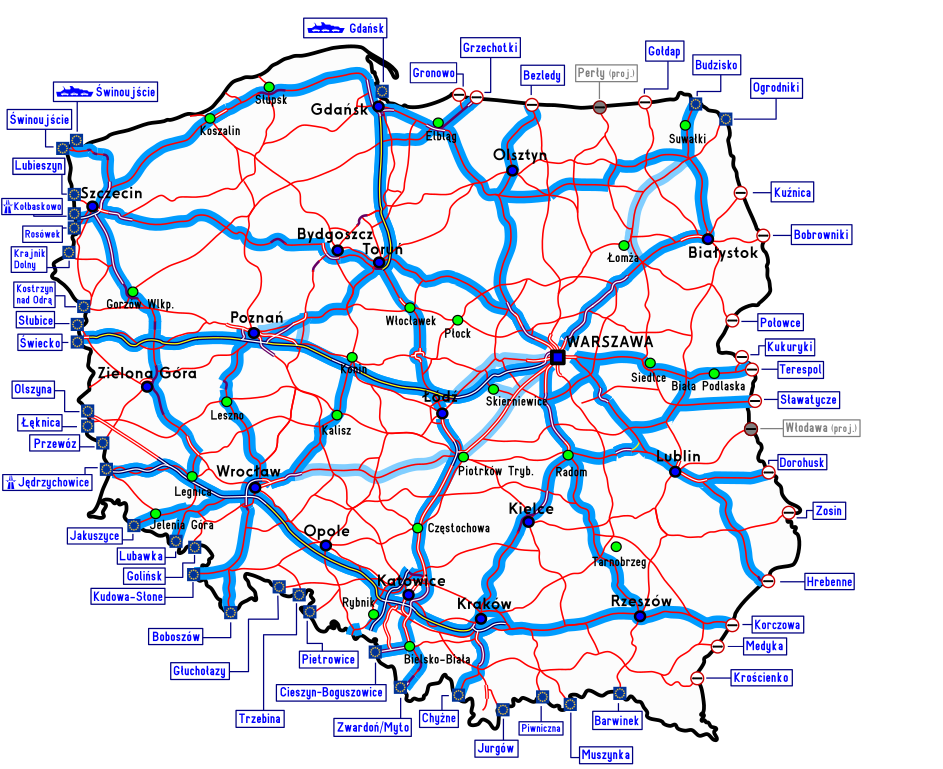
Road network of Poland during Euro 2012
Summary[edit]
| Description |
English: Map of national roads in Poland during EURO 2012. Free crossing through a country border (Schengen Area) Functioning border crossing with non-EU country Planned border crossing with non-EU country (with name) - maritime border crossing GDDKiA recommended route by GDDKiA alternative route National road National road, dual carriageway Expressway Expressway, double carriageway Motorway (free, toll motorways have yellow line!) Polski: Mapa sieci dróg krajowych w Polsce podczas EURO 2012. Swobodne przekraczanie granicy (Układ z Schengen) Czynne przejście graniczne z krajem z poza Unii Europejskiej Planowane przejście graniczne z krajem z poza Unii Europejskiej Oznaczenie morskiego przejścia granicznego Zalecana trasa GDDKiA Alternatywna trasa GDDKiA Droga krajowa jednojezdniowa Droga krajowa dwujezdniowa Droga ekspresowa jednojezdniowa Droga ekspresowa dwujezdniowa Autostrada bezpłatna (płatne oznaczone dodatkowo żółtą linią!) |
| Date | (UTC) |
| Source |
This file was derived from: Drogi krajowe w Polsce.svg: |
| Author |
|
| This is a retouched picture, which means that it has been digitally altered from its original version. The original can be viewed here: Drogi krajowe w Polsce.svg:
|
Licensing[edit]
I, the copyright holder of this work, hereby publish it under the following license:
This file is licensed under the Creative Commons Attribution-Share Alike 3.0 Unported license.
- You are free:
- to share – to copy, distribute and transmit the work
- to remix – to adapt the work
- Under the following conditions:
- attribution – You must give appropriate credit, provide a link to the license, and indicate if changes were made. You may do so in any reasonable manner, but not in any way that suggests the licensor endorses you or your use.
- share alike – If you remix, transform, or build upon the material, you must distribute your contributions under the same or compatible license as the original.
Original upload log[edit]
This image is a derivative work of the following images:
- File:Drogi_krajowe_w_Polsce.svg licensed with Cc-by-sa-3.0
- 2012-10-23T08:52:02Z Mulat 750x611 (1759303 Bytes) korekta błędu opisu przejść granicznych Medyka/Krościenko correction of the description of border checkpoints Medyka/Krościenko
- 2012-06-16T11:24:33Z Miko101 750x611 (1375510 Bytes) korekta koloru tła Polski
- 2012-06-16T11:21:52Z Miko101 750x611 (1375510 Bytes) aktualizacja
- 2012-04-17T18:28:18Z Miko101 727x619 (1350640 Bytes) {{Information |Description ={{en|1=Map of [[w:national roads in Poland|national roads]] in [[w:Poland|Poland]]. {{Legend||Free crossing through a country border (Schengen Area)|file=EU-Icon.svg}} {{Legend||Functioning bor
Uploaded with derivativeFX
File history
Click on a date/time to view the file as it appeared at that time.
| Date/Time | Thumbnail | Dimensions | User | Comment | |
|---|---|---|---|---|---|
| current | 23:22, 22 December 2012 | | 750 × 611 (1.82 MB) | Musp (talk | contribs) | == {{int:filedesc}} == {{Information |Description={{en|1=Map of national roads in Poland during EURO 2012. {{Legend||Free crossing through a country border (Schengen Area)|file=EU-Ico... |
You cannot overwrite this file.
File usage on Commons
There are no pages that use this file.
File usage on other wikis
The following other wikis use this file:
- Usage on pl.wikipedia.org