File:Disturnell Mapa de los Estados Unidos de Mejico 1847 UTA.jpg

Original file (1,488 × 1,071 pixels, file size: 1.11 MB, MIME type: image/jpeg)
Captions
Captions
Summary[edit]
| Title |
Español: Mapa de los Estados Unidos de Mejico |
||||||||||||||||||||||||||
| Description |
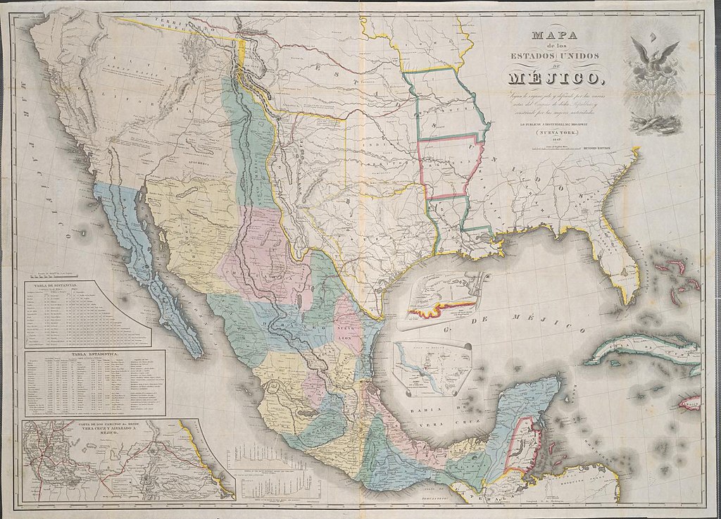
English: Recognizing the growing interest in Texas following its annexation by the United States and the ongoing tensions with Mexico in 1845, New York publisher John Disturnell (1801-1877) bought the copper plates of the 1828 map of Mexico by White, Gallaher and White and reissued it beginning the next year with his own name on it. This 1847 edition, while actually the 7th edition, was the first of seven variants that year. The variations were so minor that negotiators were probably not aware that the "7th edition" from 1847 was attached to the U.S. treaty, while the "12th edition" bearing the same year was attached to the Mexican copy. One of the most glaring errors of Disturnell's maps and their predecessors was the distortion of the location of El Paso del Norte (today's Juarez, Mexico). The maps show it miles north and east of its actual location, and, thus by the treaty, the boundary would run miles north of what the U.S. had thought they had agreed upon. The two countries appointed a joint boundary commission that spent the next several years properly surveying the boundary lines, during which time they corrected the errors. |
||||||||||||||||||||||||||
| Date | |||||||||||||||||||||||||||
| Source | UTA Libraries Cartographic Connections: map / text | ||||||||||||||||||||||||||
| Creator |
|
||||||||||||||||||||||||||
| Credit line |
English: The University of Texas at Arlington Libraries Special Collections |
||||||||||||||||||||||||||
| Geotemporal data | |||||||||||||||||||||||||||
| Map location | Mexico | ||||||||||||||||||||||||||
| Georeferencing | If inappropriate please set warp_status = skip to hide. | ||||||||||||||||||||||||||
| Bibliographic data | |||||||||||||||||||||||||||
| Place of publication | New York City | ||||||||||||||||||||||||||
| Publisher |
|
||||||||||||||||||||||||||
| Archival data | |||||||||||||||||||||||||||
| Collection |
|
||||||||||||||||||||||||||
| Dimensions | height: 76 cm (29.9 in); width: 105 cm (41.3 in) | ||||||||||||||||||||||||||
| Medium | hand-colored engraving | ||||||||||||||||||||||||||
| artwork-references |
Martin, Lawrence (1937) Disturnell's Map, Washington, D.C.: U.S. Government Printing Office Wheat, Carl I. Mapping the Trans-Mississippi West 1540-1861, 3, San Francisco: The Institute of Historical Cartography, no. 540 , pp. 6, 259 Huseman, Ben W. (2014) The Price of Manifest Destiny: Maps Relating to Wars in the Southwest Borderlands, 1800-1866, Arlington: The University of Texas at Arlington Libraries Special Collections, no. 3 , pp. 6−7 |
||||||||||||||||||||||||||
Licensing[edit]

|
This file was provided to Wikimedia Commons by the University of Texas at Arlington Libraries as part of a cooperation project. The University of Texas at Arlington Libraries is part of the University of Texas at Arlington, a public research university located in Arlington, Texas.
|
|
The author died in 1877, so this work is in the public domain in its country of origin and other countries and areas where the copyright term is the author's life plus 100 years or fewer. This work is in the public domain in the United States because it was published (or registered with the U.S. Copyright Office) before January 1, 1929. | |
| This file has been identified as being free of known restrictions under copyright law, including all related and neighboring rights. | |
File history
Click on a date/time to view the file as it appeared at that time.
| Date/Time | Thumbnail | Dimensions | User | Comment | |
|---|---|---|---|---|---|
| current | 18:34, 7 May 2021 | | 1,488 × 1,071 (1.11 MB) | Michael Barera (talk | contribs) | == {{int:filedesc}} == {{Map |title = ''Mapa de los Estados Unidos de Mejico'' |description = {{en|Recognizing the growing interest in Texas following its annexation by the United States and the ongoing tensions with Mexico in 1845, New York publisher John Disturnell (1801-1877) bought the copper plates of the 1828 map of Mexico by White, Gallaher and White and reissued it beginning the next year with his own name on it. This 1847 edition, while actually the 7th edition, w... |
You cannot overwrite this file.
File usage on Commons
The following page uses this file: