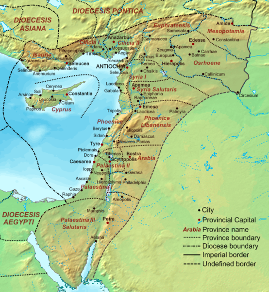
File:Dioecesis Orientis 400 AD.png
From Wikimedia Commons, the free media repository
Jump to navigation
Jump to search

Size of this preview: 554 × 600 pixels. Other resolutions: 222 × 240 pixels | 620 × 671 pixels.
Original file (620 × 671 pixels, file size: 373 KB, MIME type: image/png)
File information
Structured data
Captions
Captions
the Levant (in Latin) or Syria (in Greek) or AlSham (in Arabic/Semitic)
Summary[edit]
| DescriptionDioecesis Orientis 400 AD.png | Map of the Diocese of the East (Dioecesis Orientis) ca. 400 AD, showing the subordinate provinces and the major cities. |
| Date | |
| Source |
Base map found at en:Topographic map#Global 1-kilometer map, otherwise self-made. Data based on maps in atlases and the internet and on contemporary sources, primarily the Notitia Dignitatum and the Synecdemus. Note: the exact course of the provincial boundaries is very uncertain and in many cases only approximate. |
| Author | Cplakidas |
Licensing[edit]
| Public domainPublic domainfalsefalse |
| I, the copyright holder of this work, release this work into the public domain. This applies worldwide. In some countries this may not be legally possible; if so: I grant anyone the right to use this work for any purpose, without any conditions, unless such conditions are required by law. |
File history
Click on a date/time to view the file as it appeared at that time.
| Date/Time | Thumbnail | Dimensions | User | Comment | |
|---|---|---|---|---|---|
| current | 17:48, 19 September 2007 |  | 620 × 671 (373 KB) | Cplakidas (talk | contribs) | {{Information |Description=Map of the en:Diocese of the East (''Dioecesis Orientis'') ca. 400 AD, showing the subordinate provinces and the major cities. |Source=Base map found at en:Topographic map#Global 1-kilometer map, otherwise self-made. |
You cannot overwrite this file.
File usage on Commons
The following 2 pages use this file:
File usage on other wikis
The following other wikis use this file:
- Usage on ar.wikipedia.org
- Usage on ast.wikipedia.org
- Usage on azb.wikipedia.org
- Usage on ba.wikipedia.org
- Usage on be.wikipedia.org
- Usage on bg.wikipedia.org
- Usage on bn.wikipedia.org
- Usage on br.wikipedia.org
- Usage on ca.wikipedia.org
- Usage on cy.wikipedia.org
- Usage on de.wikipedia.org
- Usage on el.wikipedia.org
- Usage on en.wikipedia.org
- Decapolis
- Orient
- Bilad al-Sham
- Arab Christians
- Coele-Syria
- Al-Harith ibn Jabalah
- Antiochia ad Cragum
- Limes Arabicus
- List of revolutions and rebellions
- Mesopotamia (Roman province)
- Diocese of the East
- History of the Roman Empire
- History of Palestine
- Syria Prima
- Al-Mundhir III ibn al-Harith
- History of the Romans in Arabia
- Samaritan revolts
- Euphratensis
- Palaestina Salutaris
- Classical Anatolia
- Transjordan (region)
View more global usage of this file.