File:Dibujo 344. Mapa Mundi de las Indias del Perú, con la división cuatripartita del imperio incaico del Tawantinsuyu.jpg
Jump to navigation
Jump to search

No higher resolution available.
Dibujo_344._Mapa_Mundi_de_las_Indias_del_Perú,_con_la_división_cuatripartita_del_imperio_incaico_del_Tawantinsuyu.jpg (734 × 530 pixels, file size: 122 KB, MIME type: image/jpeg)
Captions
Captions
Add a one-line explanation of what this file represents
Summary[edit]
| Description |
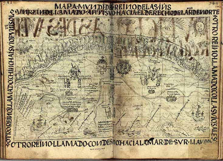
Español: Dibujo 344. Mapa Mundi de las Indias del Perú, con la división cuatripartita del imperio incaico del Tawantinsuyu |
| Date | |
| Source | http://img.kb.dk/ha/manus/POMA/poma550/POMA1001.jpg |
| Author | Felipe Guaman Poma de Ayala |
Licensing[edit]
This file is licensed under the Creative Commons Attribution-Share Alike 4.0 International license.
- You are free:
- to share – to copy, distribute and transmit the work
- to remix – to adapt the work
- Under the following conditions:
- attribution – You must give appropriate credit, provide a link to the license, and indicate if changes were made. You may do so in any reasonable manner, but not in any way that suggests the licensor endorses you or your use.
- share alike – If you remix, transform, or build upon the material, you must distribute your contributions under the same or compatible license as the original.
File history
Click on a date/time to view the file as it appeared at that time.
| Date/Time | Thumbnail | Dimensions | User | Comment | |
|---|---|---|---|---|---|
| current | 19:11, 13 June 2017 | | 734 × 530 (122 KB) | Nibelungshogun (talk | contribs) | User created page with UploadWizard |
You cannot overwrite this file.
File usage on Commons
There are no pages that use this file.