File:Diamond Peak, Colorado River.jpg
Jump to navigation
Jump to search

Size of this preview: 508 × 600 pixels. Other resolutions: 203 × 240 pixels | 406 × 480 pixels | 650 × 768 pixels | 867 × 1,024 pixels | 1,984 × 2,343 pixels.
Original file (1,984 × 2,343 pixels, file size: 1.46 MB, MIME type: image/jpeg)
Captions
Captions
Add a one-line explanation of what this file represents
Summary[edit]
| Description |
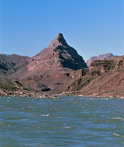
English: View south and downriver toward Diamond Peak (Redwall Limestone peak) and gneiss and granite on west side of river mile 222.4. |
| Date | |
| Source | https://www.sciencebase.gov/catalog/item/5c75adb5e4b0fe48cb4a5ed8 |
| Author | George Billingsley, U.S. Geological Survey |
| Camera location | | View this and other nearby images on: OpenStreetMap |
|---|
Licensing[edit]
This image is in the public domain in the United States because it only contains materials that originally came from the United States Geological Survey, an agency of the United States Department of the Interior. For more information, see the official USGS copyright policy.
|
File history
Click on a date/time to view the file as it appeared at that time.
| Date/Time | Thumbnail | Dimensions | User | Comment | |
|---|---|---|---|---|---|
| current | 04:45, 6 March 2021 | | 1,984 × 2,343 (1.46 MB) | Ron Clausen (talk | contribs) | crop, exposure |
| 04:45, 6 March 2021 |  | 4,187 × 2,731 (9.04 MB) | Ron Clausen (talk | contribs) | Uploaded a work by George Billingsley, U.S. Geological Survey from https://www.sciencebase.gov/catalog/item/5c75adb5e4b0fe48cb4a5ed8 with UploadWizard |
You cannot overwrite this file.
File usage on Commons
There are no pages that use this file.
File usage on other wikis
The following other wikis use this file:
- Usage on en.wikipedia.org