File:Detailed map of Wakefield-Peacedale, Rhode Island.png
Jump to navigation
Jump to search
No higher resolution available.
Detailed_map_of_Wakefield-Peacedale,_Rhode_Island.png (575 × 425 pixels, file size: 51 KB, MIME type: image/png)
Captions
Captions
Add a one-line explanation of what this file represents
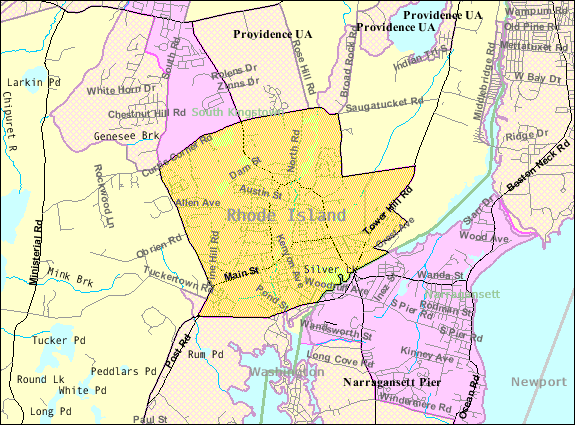
| Description | Map of Wakefield-Peacedale, a census-designated place in the town of South Kingstown in Washington County, Rhode Island, United States, with its boundaries at the time of the 2000 census. | |||
| Date | Unknown date; downloaded by me on 29 December 2008 | |||
| Source | http://factfinder.census.gov/leg1/44/123071444.gif, from http://factfinder.census.gov | |||
| Author | United States Census Bureau | |||
| Permission (Reusing this file) |
|

File history
Click on a date/time to view the file as it appeared at that time.
| Date/Time | Thumbnail | Dimensions | User | Comment | |
|---|---|---|---|---|---|
| current | 14:46, 29 December 2008 | | 575 × 425 (51 KB) | Nyttend (talk | contribs) | {{Information |Description=Map of {{w|Wakefield-Peacedale, Rhode Island|Wakefield-Peacedale}}, a {{w|census-designated place}} in the town of {{w|South Kingstown, Rhode Island|South Kingstown}} in {{w|Washington County, Rhode Island|Washington County}}, { |
You cannot overwrite this file.
File usage on Commons
There are no pages that use this file.
File usage on other wikis
The following other wikis use this file:
- Usage on ca.wikipedia.org
- Usage on ceb.wikipedia.org
- Usage on en.wikipedia.org
- Usage on es.wikipedia.org
- Usage on eu.wikipedia.org
- Usage on fa.wikipedia.org
- Usage on sh.wikipedia.org
- Usage on sr.wikipedia.org
- Usage on tt.wikipedia.org
- Usage on www.wikidata.org