File:Der Weisse Vogel Flugroute-de.svg
Jump to navigation
Jump to search

Size of this PNG preview of this SVG file: 593 × 599 pixels. Other resolutions: 237 × 240 pixels | 475 × 480 pixels | 760 × 768 pixels | 1,013 × 1,024 pixels | 2,027 × 2,048 pixels | 1,422 × 1,437 pixels.
Original file (SVG file, nominally 1,422 × 1,437 pixels, file size: 61 KB)
Captions
Captions
Add a one-line explanation of what this file represents
Summary[edit]
| Description |
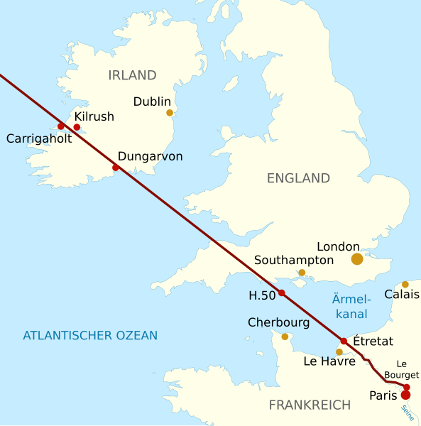
Deutsch: Karte, die die Flugroute des Weißen Vogels (Oiseau Blanc) über den Nordwesten Frankreichs, Südengland und Irland im Jahr 1927 zeigt. English: Map showing the flight over the United Kingdom and the North-East of France of the Oiseau Blanc in 1927 Français : Carte du vol de l'Oiseau Blanc au-dessus des îles britanniques et du Nord-Ouest de la France en 1927 |
| Date | |
| Source | File:Oiseau_Blanc_effective_flight-fr.svg |
| Author | United_Kingdom_and_North-West_France.svg: cropped version of Europe_blank_laea_location_map.svg by Alexrk2 from naturalearthdata data; derivative work: Pethrus (talk) |
| Other versions |
Derivative works of this file: |

|
This SVG file contains embedded text that can be translated into your language, using any capable SVG editor, text editor or the SVG Translate tool. For more information see: About translating SVG files. |
Licensing[edit]
This file is licensed under the Creative Commons Attribution 3.0 Unported license.
- You are free:
- to share – to copy, distribute and transmit the work
- to remix – to adapt the work
- Under the following conditions:
- attribution – You must give appropriate credit, provide a link to the license, and indicate if changes were made. You may do so in any reasonable manner, but not in any way that suggests the licensor endorses you or your use.
File history
Click on a date/time to view the file as it appeared at that time.
| Date/Time | Thumbnail | Dimensions | User | Comment | |
|---|---|---|---|---|---|
| current | 19:52, 1 October 2011 | | 1,422 × 1,437 (61 KB) | RIMOLA (talk | contribs) |
You cannot overwrite this file.
File usage on Commons
There are no pages that use this file.
File usage on other wikis
The following other wikis use this file:
- Usage on de.wikipedia.org