File:Denman Glacier Losing Some of Its Footing.jpg

Original file (4,096 × 2,731 pixels, file size: 2.21 MB, MIME type: image/jpeg)
Captions
Captions
Summary[edit]
| Description |
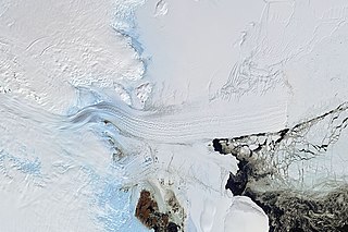
English: Using a combination of satellite sensors, scientists recently found that Denman Glacier has been retreating both above and below the water line. That one glacier in East Antarctica holds as much ice as half of West Antarctica, so scientists are concerned about its stability.
From 1996 to 2018, the grounding line along the western flank of Denman Glacier retreated 5.4 kilometers (3.4 miles), according to a new study by scientists from NASA’s Jet Propulsion Laboratory and the University of California, Irvine (UCI). The grounding line is the point at which a glacier last touches the seafloor before it begins to float. Behind the grounding line, the ice is attached to the bedrock; beyond it, glacial ice floats on the ocean as an ice tongue or shelf. The retreat of the grounding line at Denman means more of the glacier’s underside is now in contact with water that could warm and melt it from below. If the grounding line continues to retreat, warmer seawater could eventually penetrate farther upstream beneath the glacier. The natural-color image at the top of this page is a mosaic of cloud-free images acquired by Landsat 8 on February 26-28, 2020. The map below provides a three-dimensional view of the bed topography—the shape of the land surface and seafloor under the ice—around Denman Glacier, as derived from measurements made by radar and gravity-sensing instruments. The pink line delineates the grounding line as measured in 1996, while yellow indicates the line observed during the new study. (Ice flows from left to right on the map.) The darker the blues, the deeper the seafloor. Note the depth around and behind (left) the grounding line. |
| Date | |
| Source | https://earthobservatory.nasa.gov/images/146709/denman-glacier-losing-some-of-its-footing |
| Author | NASA Earth Observatory images by Joshua Stevens, using data courtesy of Brancato, V., et al. (2020), and Landsat data from the U.S. Geological Survey. Story by Michael Carlowicz, NASA Earth Observstory, with Jane Lee and Ian O’Neill, Jet Propulsion Laboratory, and Brian Bell, University of California, Irvine. |
Licensing[edit]
| This file is in the public domain in the United States because it was solely created by NASA. NASA copyright policy states that "NASA material is not protected by copyright unless noted". (See Template:PD-USGov, NASA copyright policy page or JPL Image Use Policy.) | ||
 |
Warnings:
|
File history
Click on a date/time to view the file as it appeared at that time.
| Date/Time | Thumbnail | Dimensions | User | Comment | |
|---|---|---|---|---|---|
| current | 09:21, 10 February 2021 | | 4,096 × 2,731 (2.21 MB) | StellarHalo (talk | contribs) | Uploaded a work by NASA Earth Observatory images by Joshua Stevens, using data courtesy of Brancato, V., et al. (2020), and Landsat data from the U.S. Geological Survey. Story by Michael Carlowicz, NASA Earth Observstory, with Jane Lee and Ian O’Neill, Jet Propulsion Laboratory, and Brian Bell, University of California, Irvine. from https://earthobservatory.nasa.gov/images/146709/denman-glacier-losing-some-of-its-footing with UploadWizard |
You cannot overwrite this file.
File usage on Commons
The following page uses this file: