File:Delfshaven, Overschie en Schiebroek.jpg
Jump to navigation
Jump to search

Size of this preview: 800 × 434 pixels. Other resolutions: 320 × 174 pixels | 640 × 347 pixels | 1,024 × 556 pixels | 1,280 × 695 pixels | 2,310 × 1,254 pixels.
Original file (2,310 × 1,254 pixels, file size: 2.81 MB, MIME type: image/jpeg)
Captions
Captions
Add a one-line explanation of what this file represents
Summary[edit]
| Description |
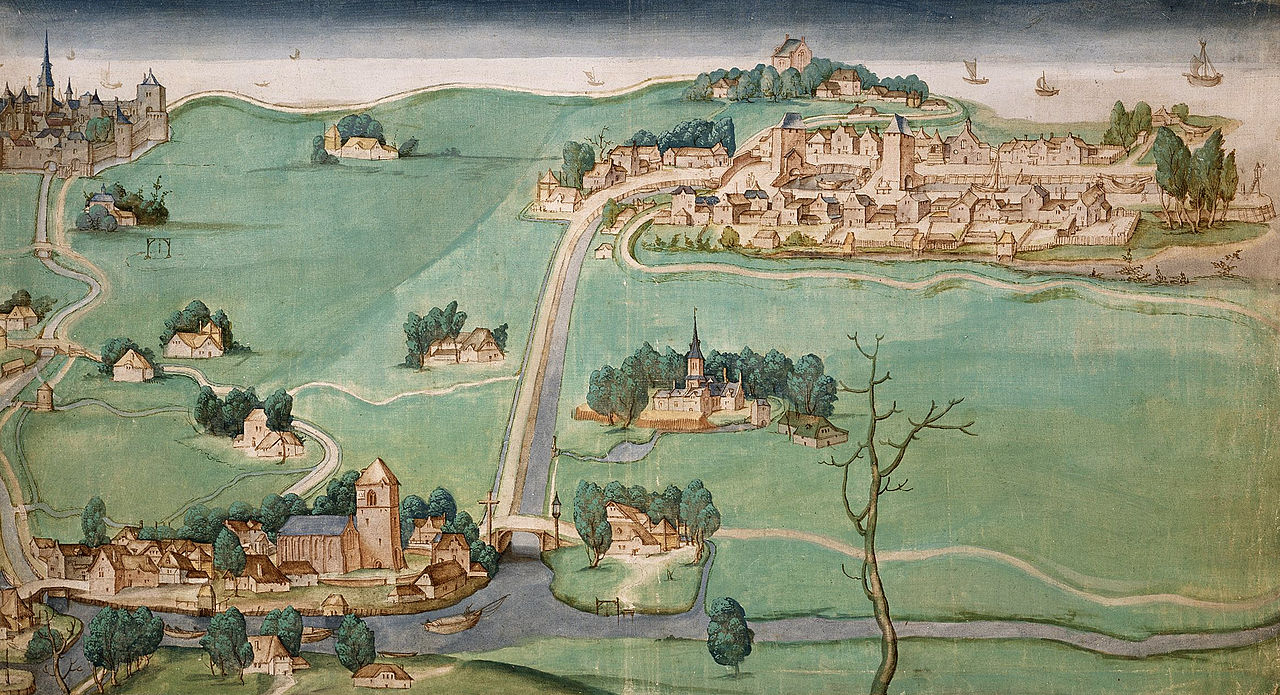
Nederlands: Kaart van de drie Schieën tussen Delfshaven, Overschie en Schiebroek aan de Rotterdamsche- en Delftse Schie. (1512)[1]
English: Map of Delfshaven, Overschie and Schiebroek at the Rotterdamsche- and Delftse Schie. (1512)[2] |
| Date | |
| Source | Nationaal Archief Nederland |
| Author | Unknown author |
- ↑ Linksboven ligt Rotterdam (aan het eind van een kronkelige Rotterdamse Schie), rechtsboven Delfshaven (aan het eind van de kaarsrechte Delfshavense Schie) en op de voorgrond ligt Overschie. De meest rechtse waterloop op de voorgrond is de Schiedamse Schie. Rechts van de Delfshavense Schie ligt het kasteel Spangen
- ↑ Rotterdam is in the top-left of the picture (at the end of the meandering Rotterdamse Schie), Delfshaven is in the top-right (at the end of of the straight Delfhavense Schie), and Overschie is in the foreground. Right of the Delfhavense Schie is Spangen Castle.
Licensing[edit]
|
This work is in the public domain in its country of origin and other countries and areas where the copyright term is the author's life plus 100 years or fewer. | |
| This file has been identified as being free of known restrictions under copyright law, including all related and neighboring rights. | |
File history
Click on a date/time to view the file as it appeared at that time.
| Date/Time | Thumbnail | Dimensions | User | Comment | |
|---|---|---|---|---|---|
| current | 09:35, 11 June 2008 | | 2,310 × 1,254 (2.81 MB) | Jan Arkesteijn (talk | contribs) | {{Information |Description={{nl|1=Kaart van de drie Schieën tussen Delfshaven, Overschie en Schiebroek aan de Rotterdamsche- en Delftse Schie. (1512)}} {{en|1=Map of Delfshaven, Overschie and Schiebroek at the Rotterdamsche- and Delftse Schie. (1512)}} | |
You cannot overwrite this file.
File usage on Commons
The following page uses this file:
File usage on other wikis
The following other wikis use this file:
- Usage on da.wikipedia.org
- Usage on de.wikipedia.org
- Usage on en.wikipedia.org
- Usage on fr.wikipedia.org
- Usage on it.wikipedia.org
- Usage on nl.wikipedia.org
- Usage on vls.wikipedia.org
- Usage on www.wikidata.org