File:DelMarCALM.png
Jump to navigation
Jump to search

Size of this preview: 800 × 515 pixels. Other resolutions: 320 × 206 pixels | 640 × 412 pixels | 815 × 525 pixels.
Original file (815 × 525 pixels, file size: 8 KB, MIME type: image/png)
Captions
Captions
Add a one-line explanation of what this file represents
Summary[edit]

|
This locator map image could be re-created using vector graphics as an SVG file. This has several advantages; see Commons:Media for cleanup for more information. If an SVG form of this image is available, please upload it and afterwards replace this template with
{{vector version available|new image name}}.
It is recommended to name the SVG file “DelMarCALM.svg”—then the template Vector version available (or Vva) does not need the new image name parameter. |
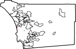
| Description |
Location map of en:Del Mar, California within en:San Diego County, California. Created using data from the en:U.S. Census Bureau. |
| Source | Government of the United States |
| Author | Government of the United States |
Licensing[edit]
This work is in the public domain in the United States because it is a work prepared by an officer or employee of the United States Government as part of that person’s official duties under the terms of Title 17, Chapter 1, Section 105 of the US Code.
Note: This only applies to original works of the Federal Government and not to the work of any individual U.S. state, territory, commonwealth, county, municipality, or any other subdivision. This template also does not apply to postage stamp designs published by the United States Postal Service since 1978. (See § 313.6(C)(1) of Compendium of U.S. Copyright Office Practices). It also does not apply to certain US coins; see The US Mint Terms of Use.
|
 | |
| This file has been identified as being free of known restrictions under copyright law, including all related and neighboring rights. | ||
Original upload log[edit]
The original description page was here. All following user names refer to en.wikipedia.
- 2005-06-17 17:39 Short Verses 815×525×2 (9981 bytes) Location map of [[Encinitas, California]] within [[San Diego County, California]]. Created using data from the [[U.S. Census Bureau]]. {{PD}}
Original upload log[edit]
| Date/Time | Dimensions | User | Comment |
|---|---|---|---|
| 25 July 2007, 08:16:44 | 815 × 525 (9981 bytes) | Smeira (talk · contribs) | {{Information |Description=Location map of [[:en:Del Mar, California]] within [[:en:San Diego County, California]]. Created using data from the [[:en:U.S. Census Bureau]]. [[:en:Category:California city locator maps]] |Source=Originally from [http://en |
File history
Click on a date/time to view the file as it appeared at that time.
| Date/Time | Thumbnail | Dimensions | User | Comment | |
|---|---|---|---|---|---|
| current | 15:23, 10 December 2014 | | 815 × 525 (8 KB) | GifTagger (talk | contribs) | Bot: Converting file to superior PNG file. (Source: DelMarCALM.gif). This GIF was problematic due to transparency and non-greyscale color table. |
You cannot overwrite this file.
File usage on Commons
The following page uses this file:
- File:DelMarCALM.gif (file redirect)