File:Deccan1956.PNG

Original file (1,950 × 2,159 pixels, file size: 593 KB, MIME type: image/png)
Captions
Captions
| Description |
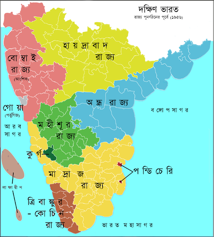
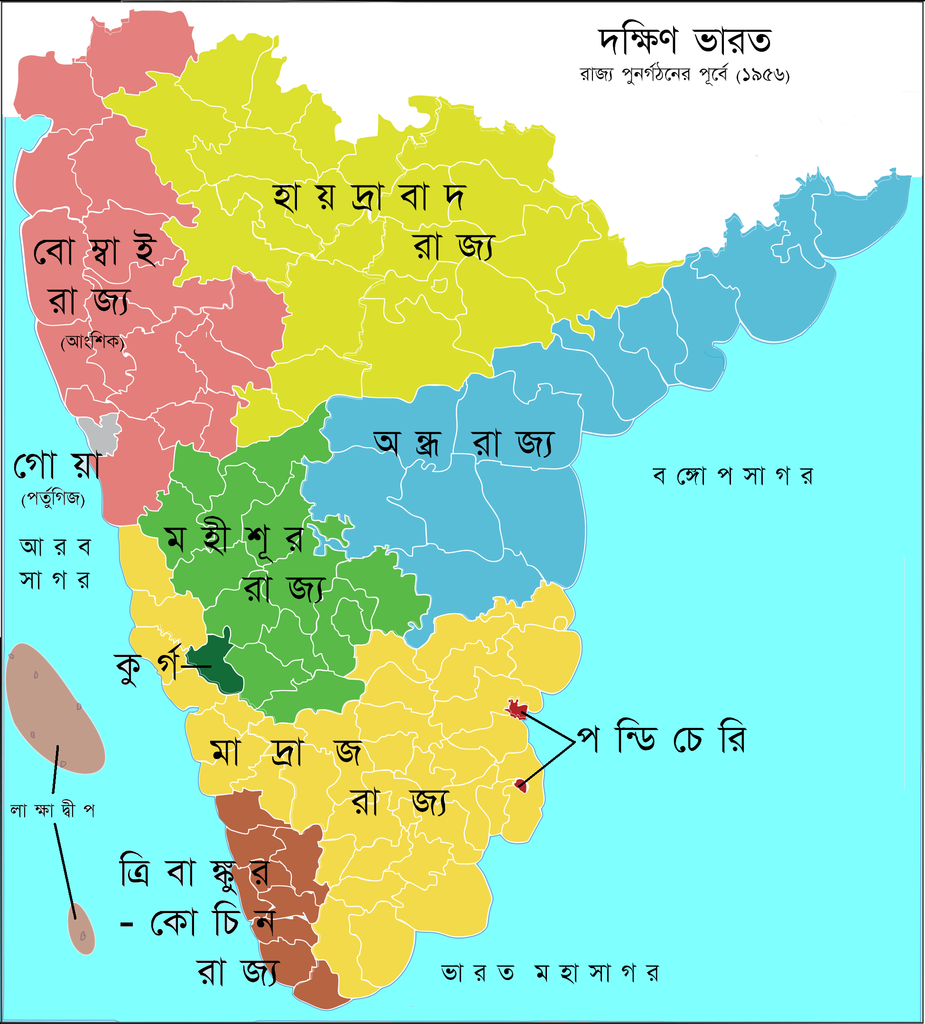
বাংলা: ১৯৫৬ সালে রাজ্য পুনর্গঠনের পূর্বে দক্ষিণ ভারত
English: South India 1956 before reform of administrative divisions.
Original upload logThis image is a derivative work of the following images:
Uploaded with derivativeFX Category:States and territories of India Category:Maps of South India Category:Travancore Category:Satavahana Category:Hyderabad State Category:Mysore Kingdom] |
| Source | |
| Author |
|Source=*South_Indian_territories.svg
|Date=2009-05-31 14:36 (UTC)
13 August 2009 (original upload date)
|Author=*South_Indian_territories.svg: AreJay
Original uploader was AreJay at en.wikipedia
|Permission= |other_versions= }}
Licensing[edit]

|
Permission is granted to copy, distribute and/or modify this document under the terms of the GNU Free Documentation License, Version 1.2 or any later version published by the Free Software Foundation; with no Invariant Sections, no Front-Cover Texts, and no Back-Cover Texts. A copy of the license is included in the section entitled GNU Free Documentation License. |
| This is a retouched picture, which means that it has been digitally altered from its original version. Modifications: 1. Deutsche Übersetzung 2. Politische Gliederung im Jahr 2009. The original can be viewed here: South Indian territories.svg:
|
- You are free:
- to share – to copy, distribute and transmit the work
- to remix – to adapt the work
- Under the following conditions:
- attribution – You must give appropriate credit, provide a link to the license, and indicate if changes were made. You may do so in any reasonable manner, but not in any way that suggests the licensor endorses you or your use.
|
|
Permission is granted to copy, distribute and/or modify this document under the terms of the GNU Free Documentation License, Version 1.2 or any later version published by the Free Software Foundation; with no Invariant Sections, no Front-Cover Texts, and no Back-Cover Texts. A copy of the license is included in the section entitled GNU Free Documentation License. |
Original upload log[edit]
Transferred from bn.wikipedia to Commons by Jayantanth using CommonsHelper.
- 2009-08-13 08:20 Jonoikobangali 1950×2159× (606747 bytes) {{Information |Description=Politische Gliederung Südindiens 2009 |Source=*[[:File:South_Indian_territories.svg|South_Indian_territories.svg]] |Date=2009-05-31 14:36 (UTC) |Author=*[[:File:South_Indian_territories.svg|South_Indian_territories.svg]]: [[:en
File history
Click on a date/time to view the file as it appeared at that time.
| Date/Time | Thumbnail | Dimensions | User | Comment | |
|---|---|---|---|---|---|
| current | 09:15, 16 February 2010 | | 1,950 × 2,159 (593 KB) | File Upload Bot (Magnus Manske) (talk | contribs) | {{BotMoveToCommons|bn.wikipedia|year={{subst:CURRENTYEAR}}|month={{subst:CURRENTMONTHNAME}}|day={{subst:CURRENTDAY}}}} {{Information |Description={{bn|{{Information |Description=Politische Gliederung Südindiens 2009 |Source=*[[:bn::File:South_Indian_ter |
You cannot overwrite this file.
File usage on Commons
There are no pages that use this file.
File usage on other wikis
The following other wikis use this file:
- Usage on bn.wikipedia.org
- Usage on pnb.wikipedia.org
- Usage on ta.wiktionary.org
- Usage on ur.wikipedia.org