File:Dardania and kosovo.png
Jump to navigation
Jump to search

Size of this preview: 414 × 599 pixels. Other resolutions: 166 × 240 pixels | 331 × 480 pixels | 818 × 1,184 pixels.
Original file (818 × 1,184 pixels, file size: 78 KB, MIME type: image/png)
Captions
Captions
Add a one-line explanation of what this file represents
Summary[edit]
| Description |
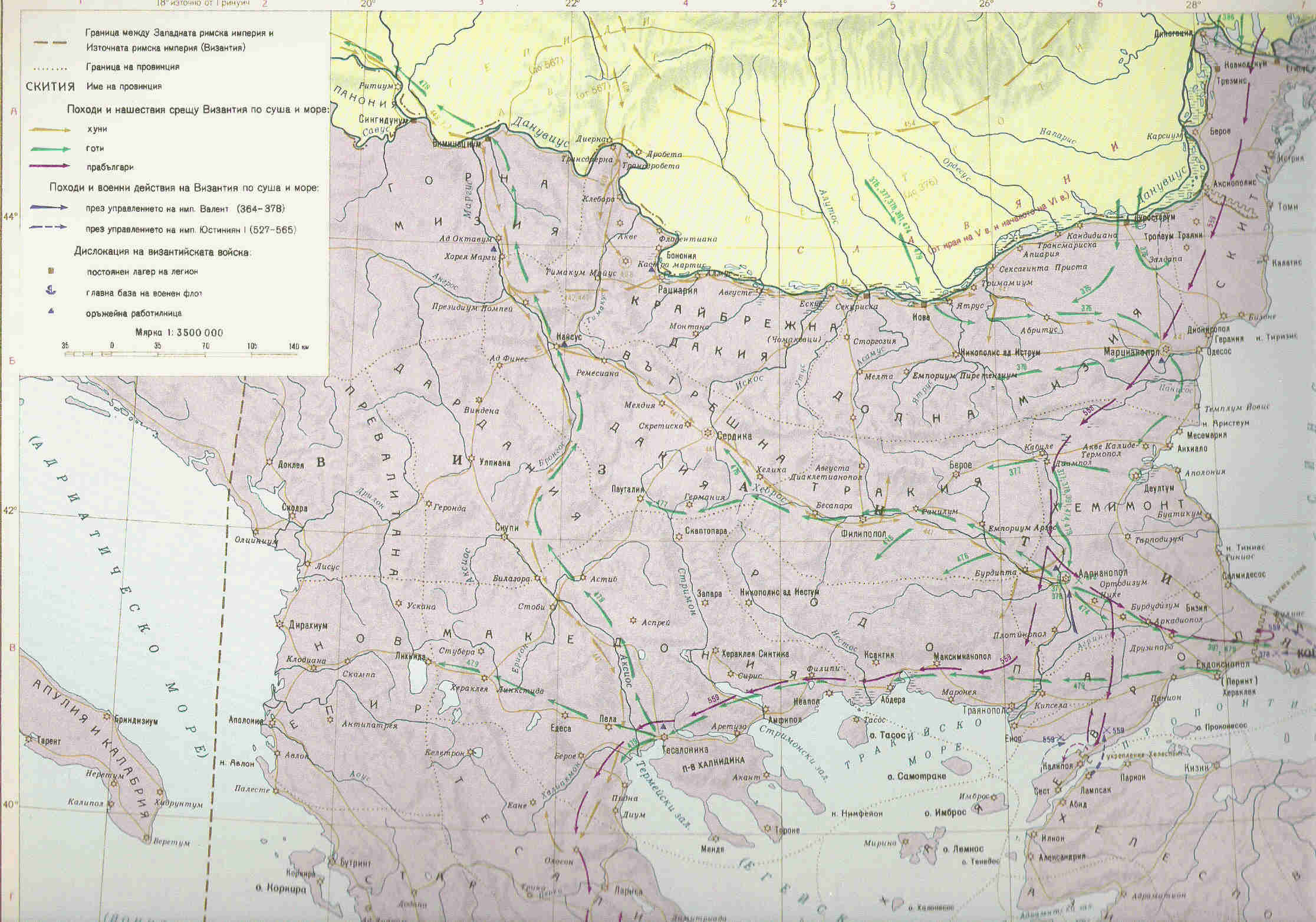
English: Borders of the Byzantine province of Dardania (6th century) compared to modern borders. |
| Date | 3 June 2009 (original upload date) |
| Source | Own work |
| Author | PANONIAN |
Licensing[edit]
| I, the copyright holder of this work, release this work into the public domain. This applies worldwide. In some countries this may not be legally possible; if so: I grant anyone the right to use this work for any purpose, without any conditions, unless such conditions are required by law. |
References[edit]
Main reference:
- Map is made according to the history map from this book: Dragan Brujić, Vodič kroz Svet Vizantije, Beograd, 2004.
Other references:
File history
Click on a date/time to view the file as it appeared at that time.
| Date/Time | Thumbnail | Dimensions | User | Comment | |
|---|---|---|---|---|---|
| current | 16:11, 4 November 2012 | | 818 × 1,184 (78 KB) | PANONIAN (talk | contribs) | improved version |
| 16:50, 27 January 2010 |  | 818 × 1,184 (74 KB) | PANONIAN (talk | contribs) | aesthetics | |
| 21:49, 3 June 2009 |  | 818 × 1,184 (74 KB) | PANONIAN (talk | contribs) | ==Description== Borders of modern Kosovo compared with borders of the Byzantine province of Dardania (6th century) ==Licence== self-made map by user:PANONIAN {{PD-self|PANONIAN}} Category:Maps of the history of Kosovo [[Category:Maps of the Byzanti |
You cannot overwrite this file.
File usage on Commons
The following 2 pages use this file:
File usage on other wikis
The following other wikis use this file:
- Usage on ba.wikipedia.org
- Usage on bg.wikipedia.org
- Usage on br.wikipedia.org
- Usage on bs.wikipedia.org
- Usage on ca.wikipedia.org
- Usage on de.wikipedia.org
- Usage on es.wikipedia.org
- Usage on eu.wikipedia.org
- Usage on fi.wikipedia.org
- Usage on fr.wikipedia.org
- Usage on gl.wikipedia.org
- Usage on he.wikipedia.org
- Usage on hr.wikipedia.org
- Usage on id.wikipedia.org
- Usage on it.wikipedia.org
- Usage on ja.wikipedia.org
- Usage on jv.wikipedia.org
- Usage on lt.wikipedia.org
- Usage on mk.wikipedia.org
- Usage on nl.wikipedia.org
- Usage on pl.wikipedia.org
- Usage on ro.wikipedia.org
- Usage on ru.wikipedia.org
- Usage on sh.wikipedia.org
- Usage on sl.wikipedia.org
- Usage on sq.wikipedia.org
- Usage on sv.wikipedia.org
- Usage on uk.wikipedia.org
- Usage on www.wikidata.org