File:Daily pedestrian traffic map, Seattle, April 1921 (MOHAI 12716).jpg
Jump to navigation
Jump to search

Size of this preview: 790 × 600 pixels. Other resolutions: 316 × 240 pixels | 633 × 480 pixels | 1,000 × 759 pixels.
Original file (1,000 × 759 pixels, file size: 122 KB, MIME type: image/jpeg)
Captions
Captions
Add a one-line explanation of what this file represents
Summary[edit]
.jpg&action=edit§ion=1)
| English: Daily pedestrian traffic map, Seattle, April 1921
( |
||||||||||||||||||||||||
|---|---|---|---|---|---|---|---|---|---|---|---|---|---|---|---|---|---|---|---|---|---|---|---|---|
| Photographer |
City of Seattle |
|||||||||||||||||||||||
| Title |
English: Daily pedestrian traffic map, Seattle, April 1921 |
|||||||||||||||||||||||
| Description |
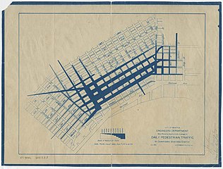
English: The map shown here, created by the Engineers Department, City of Seattle, illustrates average daily pedestrian traffic in the Seattle Downtown Business District for April 1921. The map extends from Blanchard Street to King Street and Railroad Avenue to 8th Street, with a scale running from 2,000 people to 50,000 people taken between 7:00 am and 6:00 pm. Handwritten on verso: "Jackson, Zoning Engineer, Member Local 21."
|
|||||||||||||||||||||||
| Depicted place |
English: United States--Washington (State)--Seattle |
|||||||||||||||||||||||
| Date | Taken on 1 April 1921 | |||||||||||||||||||||||
| Medium |
English: 1 map |
|||||||||||||||||||||||
| Dimensions | height: 12.5 in (31.7 cm); width: 9.5 in (24.1 cm) | |||||||||||||||||||||||
| Collection |
|
|||||||||||||||||||||||
| Current location | ||||||||||||||||||||||||
| Accession number | ||||||||||||||||||||||||
| Source |
English: Museum of History and Industry |
|||||||||||||||||||||||
| Permission (Reusing this file) |
|
|||||||||||||||||||||||
| Credit Line | MOHAI, 2018.3.8.3 | |||||||||||||||||||||||
File history
Click on a date/time to view the file as it appeared at that time.
| Date/Time | Thumbnail | Dimensions | User | Comment | |
|---|---|---|---|---|---|
| current | 18:02, 19 November 2020 | | 1,000 × 759 (122 KB) | BMacZeroBot (talk | contribs) | Batch upload (Commons:Batch uploading/University of Washington Digital Collections) |
You cannot overwrite this file.
File usage on Commons
The following page uses this file:
.jpg)
.jpg&oldid=668780472)