File:Da Qing fen sheng yu tu LOC 2002626726-1.jpg
Jump to navigation
Jump to search

Size of this preview: 698 × 599 pixels. Other resolutions: 280 × 240 pixels | 559 × 480 pixels | 894 × 768 pixels | 1,193 × 1,024 pixels | 2,385 × 2,048 pixels | 5,280 × 4,534 pixels.
Original file (5,280 × 4,534 pixels, file size: 2.43 MB, MIME type: image/jpeg)
Captions
Captions
Add a one-line explanation of what this file represents
Summary[edit]
| Description |
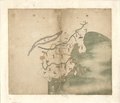
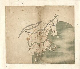
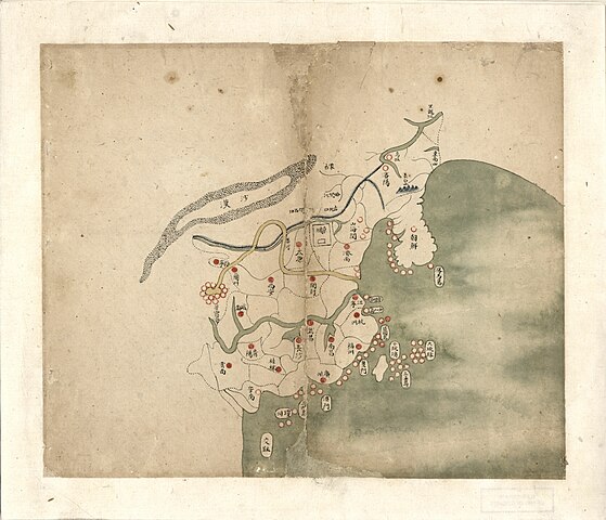
English: The General Map of the 1754 Da Qing Fensheng Yutu, showing the Qing Empire during the reign of the Qianlong Emperor. Provincial borders and capitals, the Yangtze and Yellow River, Great Wall and Willow Palisade, and Gobi Desert are clearly marked. Vietnam appears twice, once as the contemporary realm of Annam (marked as a Chinese province) and once as the ancient land of Jiaozhi (vaguely placed as an island somewhere in the southern seas). Korea and Tsushima ("Fengma Island") appear. The Mongols are placed as a small group in Inner Mongolia. Pen-and-ink and watercolor. Library of Congress copy, G2305 .D35 1782 Vault Shelf, G2305 .T15 17-- Vault.
中文:大清分省輿圖, 大清分省舆图, Daqing Fengsheng Yutu, Ta Ching Feng-sheng Yü-t'u. |
||
| Title | English: Provincial Atlas of the Qing Empire
中文:《大清分省輿圖》, Daqing Fensheng Yutu |
||
| Shelf ID | G2305 .D35 1760 | ||
| Parent | https://www.loc.gov/resource/g7820m.gct00229/ | ||
| Sheet title | English: Untitled
中文:無 |
||
| Date |
English: 1754
中文:乾隆十九年 |
||
| Source | LOC | ||
| Author | Unknown author | ||
| Permission (Reusing this file) |
|
||
| Other versions |
|
||
| Location | China · Korea · Tsushima · Vietnam · Mongolia | ||
| Part of | American Memory · General Maps · Catalog · Geography And Map Division | ||
| Subject | Atlases · Early Maps · Maps · Early Works To 1800 · China · Administrative And Political Divisions · Manuscript Maps |


Licensing[edit]
|
This is a faithful photographic reproduction of a two-dimensional, public domain work of art. The work of art itself is in the public domain for the following reason:
The official position taken by the Wikimedia Foundation is that "faithful reproductions of two-dimensional public domain works of art are public domain".
This photographic reproduction is therefore also considered to be in the public domain in the United States. In other jurisdictions, re-use of this content may be restricted; see Reuse of PD-Art photographs for details. | ||||
| Annotations | This image is annotated: View the annotations at Commons |
File history
Click on a date/time to view the file as it appeared at that time.
| Date/Time | Thumbnail | Dimensions | User | Comment | |
|---|---|---|---|---|---|
| current | 14:52, 3 January 2019 | | 5,280 × 4,534 (2.43 MB) | Fæ (talk | contribs) | LOC Maps multisheet https://www.loc.gov/item/2002626726/ sheet 1 of 20 #7502 |
You cannot overwrite this file.
File usage on Commons
The following 4 pages use this file:
File usage on other wikis
The following other wikis use this file:
- Usage on www.wikidata.org