File:DEU Wernberg-Köblitz COA.svg
Jump to navigation
Jump to search

Size of this PNG preview of this SVG file: 583 × 600 pixels. Other resolutions: 233 × 240 pixels | 466 × 480 pixels | 746 × 768 pixels | 995 × 1,024 pixels | 1,990 × 2,048 pixels | 894 × 920 pixels.
Original file (SVG file, nominally 894 × 920 pixels, file size: 4 KB)
Captions
Captions
Add a one-line explanation of what this file represents
Summary[edit]
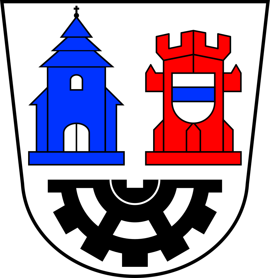
| Coat of arms | Deutsch: von Wernberg-Köblitz English: of the municipality of Wernberg-Köblitz |
|||
| Blazon | Deutsch: In Silber über einem unterhalben schwarzen Zahnrad nebeneinander ein blaues Kirchengebäude mit dreigeschossigem Turmdach und ein über Eck gestellter roter Zinnenturm, dem ein silberner Schild, darin ein blauer Balken, aufgelegt ist. |
|||
| Blazon reference | [1] | |||
| Tincture | argentazuregulessable |
|||
| Date | from 21 April 1975; SVG 30 September 2017 | |||
| Object history |
Deutsch: In der Wappengestaltung kommt die Neuformation des Marktes Wernberg-Köblitz aus den Gemeinden Wernberg und Oberköblitz zum 1. Januar 1974 zum Ausdruck. Der rote Zinnenturm mit dem aufgelegten Schild ist dem Bergfried der Burg Wernberg nachempfunden und wurde in vereinfachter Form dem alten Wappen des Marktes Wernberg entnommen; das silberne Schildchen mit blauem Balken verweist auf die Landgrafen von Leuchtenberg, die das Wappen 1560 verliehen haben. Das blaue Kirchengebäude erinnert in heraldisch vereinfachter Form an die Pfarrkirche St. Emmeram in Oberköblitz mit ihrem charakteristischen dreigeschossigen Turmdach. Das Zahnrad steht für die Entwicklung der Gemeinde zum bedeutenden Industriestandort im nördlichen Landkreis Schwandorf (Glasproduktion u.a.). Kirche und Zahnrad stammen aus dem 1968 von der ehemaligen Gemeinde Oberköblitz angenommenen Wappen. |
|||
| Artist | Original: u Vector: |
|||
| Source | Own work based on: [2] | |||
| Permission (Reusing this file) |
|
|||
| Other versions |
|
|||
| SVG development |
Licensing[edit]
I, the copyright holder of this work, hereby publish it under the following license:
This file is licensed under the Creative Commons Attribution-Share Alike 4.0 International license.
- You are free:
- to share – to copy, distribute and transmit the work
- to remix – to adapt the work
- Under the following conditions:
- attribution – You must give appropriate credit, provide a link to the license, and indicate if changes were made. You may do so in any reasonable manner, but not in any way that suggests the licensor endorses you or your use.
- share alike – If you remix, transform, or build upon the material, you must distribute your contributions under the same or compatible license as the original.
This file depicts the coat of arms of a German Körperschaft des öffentlichen Rechts (corporation governed by public law). According to § 5 Abs. 1 of the German Copyright law, official works like coats of arms are in the public domain.
Note: The usage of coats of arms is governed by legal restrictions, independent of the copyright status of the depiction shown here.
|
 |
File history
Click on a date/time to view the file as it appeared at that time.
| Date/Time | Thumbnail | Dimensions | User | Comment | |
|---|---|---|---|---|---|
| current | 07:31, 30 September 2017 | | 894 × 920 (4 KB) | Chris die Seele (talk | contribs) | User created page with UploadWizard |
You cannot overwrite this file.
File usage on Commons
The following 3 pages use this file:
File usage on other wikis
The following other wikis use this file:
- Usage on cs.wikipedia.org
- Usage on de.wikipedia.org
- Nabburg
- Trausnitz
- Schmidgaden
- Liste der Wappen im Landkreis Schwandorf
- Pfreimd
- Woppenhof
- Wernberg-Köblitz
- Liste der Baudenkmäler in Wernberg-Köblitz
- Feistelberg
- Schwarzberg (Wernberg-Köblitz)
- Diebrunn
- Neunaigen
- Vorlage:Navigationsleiste Ortsteile von Wernberg-Köblitz
- Damelsdorf
- Friedersdorf (Wernberg-Köblitz)
- Saltendorf (Wernberg-Köblitz)
- Maierhof (Wernberg-Köblitz)
- Oberndorf (Wernberg-Köblitz)
- Alletshof
- Deindorf (Wernberg-Köblitz)
- Glaubendorf (Wernberg-Köblitz)
- Gröbmühle
- Kettnitzmühle
- Kötschdorf
- Losau (Wernberg-Köblitz)
- Oberköblitz
- Prügelhof
- Rattenberg (Wernberg-Köblitz)
- Schiltern (Wernberg-Köblitz)
- Schmalhof (Wernberg-Köblitz)
- Trad (Wernberg-Köblitz)
- Unterköblitz (Wernberg-Köblitz)
- Wernberg (Wernberg-Köblitz)
- Wohlsbach
- Usage on fa.wikipedia.org
- Usage on hy.wikipedia.org
- Usage on kk.wikipedia.org
- Usage on ms.wikipedia.org
- Usage on pl.wikipedia.org
- Usage on ro.wikipedia.org
- Usage on uk.wikipedia.org
- Usage on uz.wikipedia.org