File:D-angusticeps-range.png
Jump to navigation
Jump to search

Size of this preview: 635 × 600 pixels. Other resolutions: 254 × 240 pixels | 508 × 480 pixels | 813 × 768 pixels | 1,084 × 1,024 pixels | 1,525 × 1,440 pixels.
Original file (1,525 × 1,440 pixels, file size: 432 KB, MIME type: image/png)
Captions
Captions
Add a one-line explanation of what this file represents
Summary[edit]
| Description |
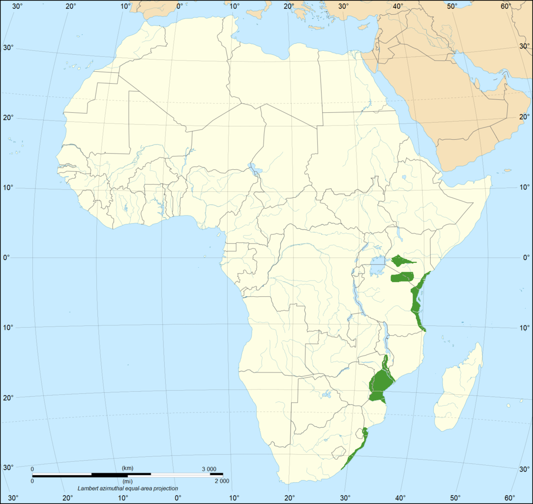
English: The geographical range of the Eastern green mamba in Africa. Data on range is from (2018). "The medical threat of mamba envenoming in sub-Saharan Africa revealed by genus-wide analysis of venom composition, toxicity and antivenomics profiling of available antivenoms". Journal of Proteomics 172: 173–189. DOI:10.1016/j.jprot.2017.08.016. PMID 28843532. Base map is File:Africa map blank.svg |
| Date | |
| Source | Own work |
| Author | Casliber |

|
File:Range of the Eastern Green Mamba.svg is a vector version of this file. It should be used in place of this PNG file when not inferior.
File:D-angusticeps-range.png → File:Range of the Eastern Green Mamba.svg
For more information, see Help:SVG. |
 |
Licensing[edit]
I, the copyright holder of this work, hereby publish it under the following license:
| This file is made available under the Creative Commons CC0 1.0 Universal Public Domain Dedication. | |
| The person who associated a work with this deed has dedicated the work to the public domain by waiving all of their rights to the work worldwide under copyright law, including all related and neighboring rights, to the extent allowed by law. You can copy, modify, distribute and perform the work, even for commercial purposes, all without asking permission.
|
File history
Click on a date/time to view the file as it appeared at that time.
| Date/Time | Thumbnail | Dimensions | User | Comment | |
|---|---|---|---|---|---|
| current | 11:27, 13 October 2019 | | 1,525 × 1,440 (432 KB) | Casliber (talk | contribs) | Now has accurate range map based on https://doi.org/10.1016/j.jprot.2017.08.016. Base map is now File:Africa map blank.svg |
| 21:34, 27 March 2018 |  | 333 × 365 (18 KB) | Maphobbyist (talk | contribs) | Actual range | |
| 16:39, 18 December 2011 |  | 454 × 398 (12 KB) | Sebastian80~commonswiki (talk | contribs) |
You cannot overwrite this file.
File usage on Commons
The following 3 pages use this file:
File usage on other wikis
The following other wikis use this file:
- Usage on ar.wikipedia.org
- Usage on arz.wikipedia.org
- Usage on bg.wikipedia.org
- Usage on bn.wikipedia.org
- Usage on ceb.wikipedia.org
- Usage on cs.wikipedia.org
- Usage on de.wikipedia.org
- Usage on es.wikipedia.org
- Usage on et.wikipedia.org
- Usage on eu.wikipedia.org
- Usage on fa.wikipedia.org
- Usage on fi.wikipedia.org
- Usage on frr.wikipedia.org
- Usage on he.wikipedia.org
- Usage on hu.wikipedia.org
- Usage on hy.wikipedia.org
- Usage on id.wikipedia.org
- Usage on ne.wikipedia.org
- Usage on pl.wikipedia.org
- Usage on pt.wikipedia.org
- Usage on ro.wikipedia.org
- Usage on ru.wikipedia.org
- Usage on sv.wikipedia.org
- Usage on th.wikipedia.org
- Usage on uk.wikipedia.org
- Usage on vi.wikipedia.org
- Usage on www.wikidata.org