File:D-Day the 6th of June - Normandy 1944 LOC 94681943.jpg
Jump to navigation
Jump to search

Size of this preview: 800 × 304 pixels. Other resolutions: 320 × 122 pixels | 640 × 243 pixels | 1,024 × 389 pixels | 1,280 × 487 pixels | 2,560 × 973 pixels | 14,649 × 5,568 pixels.
Original file (14,649 × 5,568 pixels, file size: 9.95 MB, MIME type: image/jpeg)
Captions
Captions
Add a one-line explanation of what this file represents
Summary[edit]
| Warning | The original file is very high-resolution. It might not load properly or could cause your browser to freeze when opened at full size. |
|---|
| Description |
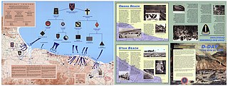
English: Shows World-War-II Normandy invasion routes. Panel title. Title at upper left: Normandy Invasion. Text, 2 local maps, and ill. (some col.) on verso. "PIN:071754-000." Available also through the Library of Congress Web site as a raster image. |
||
| Title | D-Day the 6th of June : Normandy 1944 | ||
| Shelf ID | G5833.N7S7 1993 .C4 MLC | ||
| Date | |||
| Source | https://www.loc.gov/item/94681943/ | ||
| Author | Center Of Military History | ||
| Permission (Reusing this file) |
|
||
| Other versions |
|
||
| Location | Normandy · France | ||
| Part of | Military Battles And Campaigns · American Memory · Catalog · Geography And Map Division | ||
| Subject | Coasts · France · Campaigns · Maps · Normandy · World War |

Licensing[edit]
This work is in the public domain in the United States because it is a work prepared by an officer or employee of the United States Government as part of that person’s official duties under the terms of Title 17, Chapter 1, Section 105 of the US Code.
Note: This only applies to original works of the Federal Government and not to the work of any individual U.S. state, territory, commonwealth, county, municipality, or any other subdivision. This template also does not apply to postage stamp designs published by the United States Postal Service since 1978. (See § 313.6(C)(1) of Compendium of U.S. Copyright Office Practices). It also does not apply to certain US coins; see The US Mint Terms of Use.
|
 | |
| This file has been identified as being free of known restrictions under copyright law, including all related and neighboring rights. | ||
File history
Click on a date/time to view the file as it appeared at that time.
| Date/Time | Thumbnail | Dimensions | User | Comment | |
|---|---|---|---|---|---|
| current | 12:15, 10 May 2018 | 14,649 × 5,568 (9.95 MB) | Fæ (talk | contribs) | LOC Maps https://www.loc.gov/item/94681943/ #59 |
You cannot overwrite this file.
File usage on Commons
The following 2 pages use this file: