File:Cyprus-CIA WFB Map.png
Jump to navigation
Jump to search

No higher resolution available.
Cyprus-CIA_WFB_Map.png (630 × 321 pixels, file size: 12 KB, MIME type: image/png)
Captions
Captions
Add a one-line explanation of what this file represents
Summary[edit]
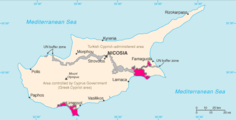
| Description | Cyprus map from CIA World Factbook 2004, converted from original GIF format |
| Date | |
| Source | CIA World Factbook: Cyprus. Archived from the original on 4 June 2004. |
| Author | United States Central Intelligence Agency |
| Other versions |
|
Licensing[edit]
This image is in the public domain because it contains materials that originally came from the United States Central Intelligence Agency's World Factbook.
|
 |
Derivative works[edit]
-
 000 Qiproja harta.PNG
 -
 Cy-map-ja.png
日本語 -
 Cypernkarta svenska.PNG
svenska -
 Cyprus BufferZoneInBlue.png
 -
 Cyprus SBAsInRed.png
 -
 Cyprus-administration-map-german.PNG
Deutsch -
 Cyprus-turkish-administration-map-german.png
Deutsch -
 Fazil Kucuk's plan of division in 1957.png
 -
 Kaart Cyprus.jpg
Nederlands


File history
Click on a date/time to view the file as it appeared at that time.
| Date/Time | Thumbnail | Dimensions | User | Comment | |
|---|---|---|---|---|---|
| current | 09:13, 27 March 2005 | | 630 × 321 (12 KB) | Wolfman~commonswiki (talk | contribs) | {{CIA-map}} |
You cannot overwrite this file.
File usage on Commons
The following page uses this file:
File usage on other wikis
The following other wikis use this file:
- Usage on ban.wikipedia.org
- Usage on bn.wikipedia.org
- Usage on el.wikipedia.org
- Usage on en.wikipedia.org
- Usage on en.wikisource.org
- Usage on eo.wikipedia.org
- Usage on fa.wikipedia.org
- Usage on hr.wikipedia.org
- Usage on hy.wikipedia.org
- Usage on ja.wikipedia.org
- Usage on lt.wiktionary.org
- Usage on pl.wikipedia.org
- Usage on ru.wikipedia.org
- Usage on zh.wikipedia.org