File:Yemyin 2007-06-25 0610Z.jpg
Original file (6,127 × 6,224 pixels, file size: 4.48 MB, MIME type: image/jpeg)
Captions
Captions
Summary[edit]
| Description |
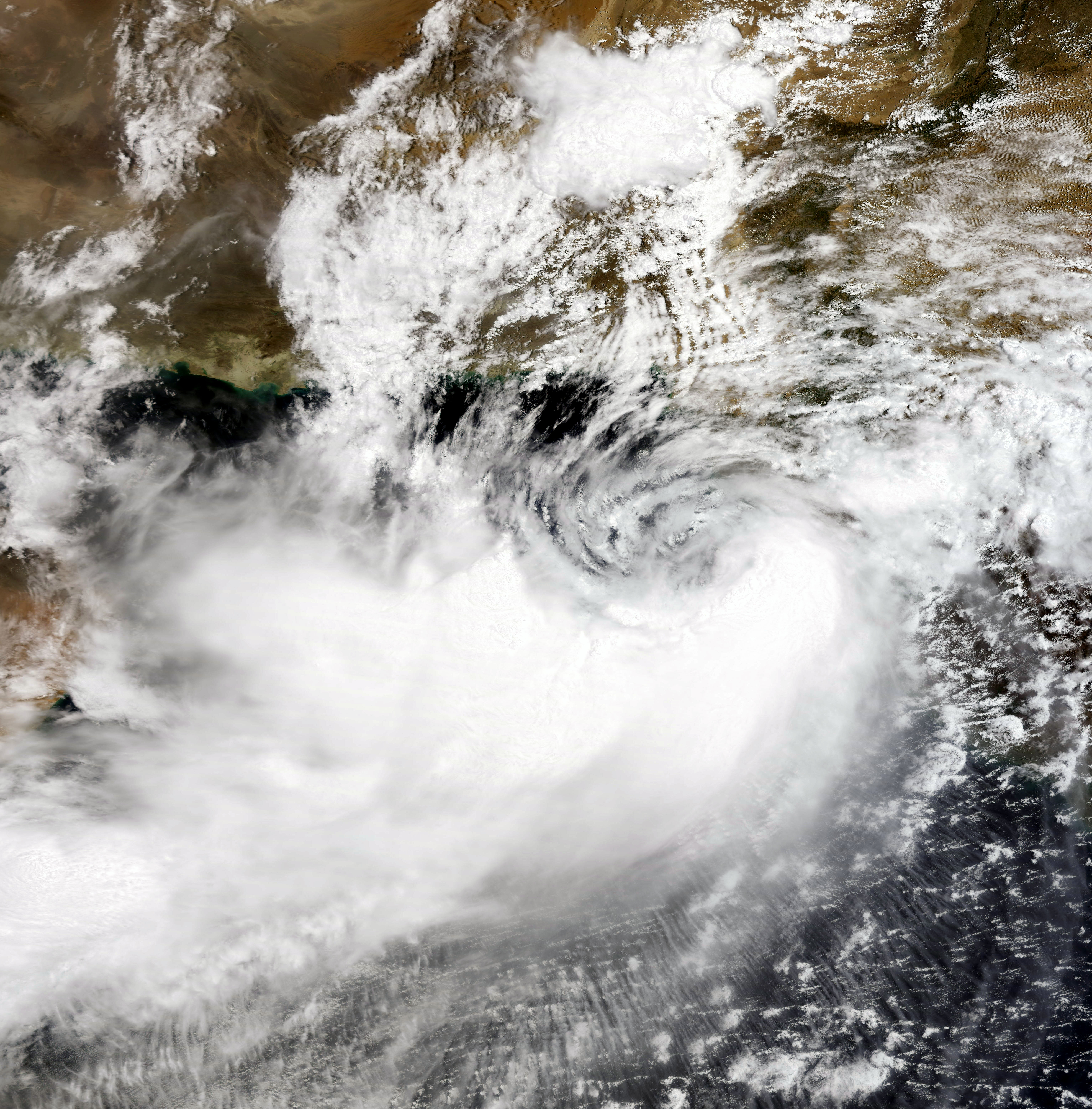
Cyclonic storms in the Arabian Sea are rare, but not unheard of. Two tropical cyclones in the space of a month, on the other hand, is quite rare indeed. Unlike its predecessor, Tropical Cyclone Gonu, Cyclone 03B originated on the opposite side of the Indian Peninsula in the Bay of Bengal. At 11:10 a.m. local time (06:10 UTC) on June 25, 2007, when the Moderate Resolution Imaging Spectroradiometer (MODIS) on NASA’s Terra satellite captured this image, Tropical Cyclone 03B was reforming in the Arabian Sea south of the Pakistan coast after having crossed over India. The storm system has a discernable spiraling shape, but does not appear well-formed in this image. The storm has no distinct eye, suggesting that it is not particularly well organized. At the time, sustained winds were measured at 60 kilometers per hour (40 miles per hour) according to the University of Hawaii’s Tropical Storm Information Center. The storm flooded India’s Andhra Pradesh province, resulting in 45 deaths, according to Weather Underground. It also caused flooding and wind damage in Karachi, Pakistan, where the death toll was around 200, according to BBC News. After crossing land, the storm reached the Arabian Sea and began to reform. As of June 26, forecasts were calling for the storm to gain some organization and power, skirt the Pakistani coast, and make landfall again somewhere near the border between Iran and Pakistan. Storm surge from Cyclone 03B was predicted to be moderately high, even though the storm is not strong, since the offshore waters are shallow, similar to the northern Gulf of Mexico. Because these kinds of storms are rare, coastal communities are particularly vulnerable to storm surge damage. |
|||||
| Date | ||||||
| Source | http://earthobservatory.nasa.gov/NaturalHazards/natural_hazards_v2.php3?img_id=14328 | |||||
| Author | NASA image by Jesse Allen, using data provided courtesy of the MODIS Rapid Response team at Goddard Space Flight Center. | |||||
| Permission (Reusing this file) |
|

File history
Click on a date/time to view the file as it appeared at that time.
| Date/Time | Thumbnail | Dimensions | User | Comment | |
|---|---|---|---|---|---|
| current | 03:20, 19 June 2010 | | 6,127 × 6,224 (4.48 MB) | Supportstorm (talk | contribs) | Sharpened/ Contrast Correction |
| 23:51, 26 June 2007 |  | 6,127 × 6,224 (4.18 MB) | Good kitty (talk | contribs) | == Summary == {{Information |Description=Cyclonic storms in the Arabian Sea are rare, but not unheard of. Two tropical cyclones in the space of a month, on the other hand, is quite rare indeed. Unlike its predecessor, Tropical Cyclone Gonu, Cyclone 03B or |
You cannot overwrite this file.
File usage on Commons
The following page uses this file:
- File:Cyclone 03B 25 jun 2007 0610Z.jpg (file redirect)
File usage on other wikis
The following other wikis use this file:
- Usage on bn.wikipedia.org
- Usage on en.wikipedia.org
- Usage on pt.wikipedia.org
- Usage on ur.wikipedia.org