File:Critically low water levels in Morocco’s reservoirs.jpg

Original file (4,010 × 2,543 pixels, file size: 5.31 MB, MIME type: image/jpeg)
Captions
Captions
Summary
[edit]
| Description |
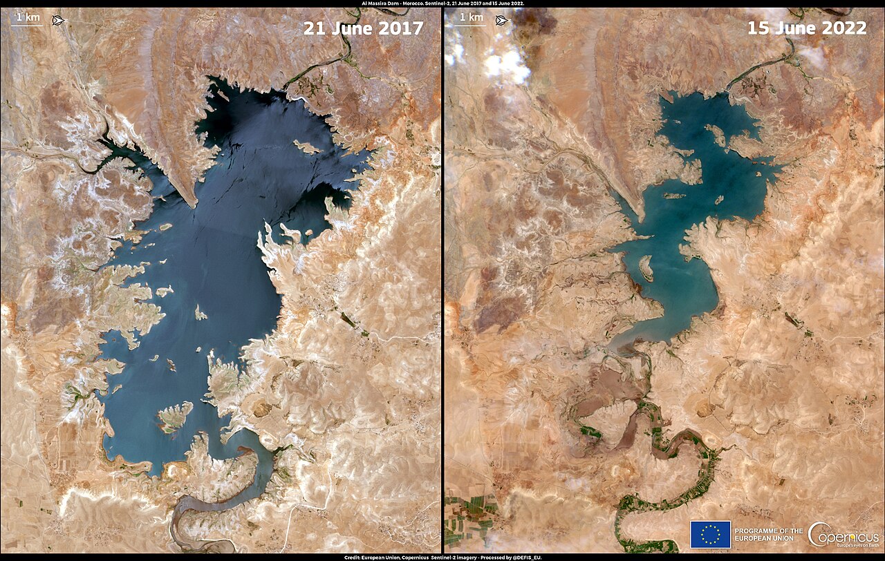
English: Drought continues to plague Morocco, causing a severe water deficit in its reservoirs. According to the country’s General Directorate of Hydraulics, on 14 June 2022 the overall reservoir fill rate stood at only 31.8%, 17% less than in 2021. In addition, several reservoirs had a residual water capacity of less than 10%. These images, acquired by the Copernicus Sentinel-2 satellites on 21 June 2017 (left) and 15 June 2022 (right), show the effects of water scarcity at the Al Massira reservoir, the second largest in the country, that is currently at 6.3% of its total capacity. |
| Date | Taken on 21 June 2017 |
| Source | Critically low water levels in Morocco’s reservoirs |
| Author | European Union, Copernicus Sentinel-2 imagery |
Licensing
[edit]

|
This image contains data from a satellite in the Copernicus Programme, such as Sentinel-1, Sentinel-2 or Sentinel-3. Attribution is required when using this image.
Attribution: Contains modified Copernicus Sentinel data 2017
The use of Copernicus Sentinel Data is regulated under EU law (Commission Delegated Regulation (EU) No 1159/2013 and Regulation (EU) No 377/2014). Relevant excerpts:
Free access shall be given to GMES dedicated data [...] made available through GMES dissemination platforms [...].
Access to GMES dedicated data [...] shall be given for the purpose of the following use in so far as it is lawful:
GMES dedicated data [...] may be used worldwide without limitations in time.
GMES dedicated data and GMES service information are provided to users without any express or implied warranty, including as regards quality and suitability for any purpose. |
File history
Click on a date/time to view the file as it appeared at that time.
| Date/Time | Thumbnail | Dimensions | User | Comment | |
|---|---|---|---|---|---|
| current | 16:32, 20 August 2023 | | 4,010 × 2,543 (5.31 MB) | OptimusPrimeBot (talk | contribs) | #Spacemedia - Upload of https://www.copernicus.eu/system/files/2022-06/image_day/20220621_DroughtMorocco.jpg via Commons:Spacemedia |
You cannot overwrite this file.
File usage on Commons
There are no pages that use this file.