File:Creating maps with Qgis.svg
Jump to navigation
Jump to search

Size of this PNG preview of this SVG file: 800 × 599 pixels. Other resolutions: 320 × 240 pixels | 640 × 479 pixels | 1,024 × 766 pixels | 1,280 × 958 pixels | 2,560 × 1,916 pixels | 2,302 × 1,723 pixels.
Original file (SVG file, nominally 2,302 × 1,723 pixels, file size: 2.2 MB)
Captions
Captions
Add a one-line explanation of what this file represents
Summary[edit]
| Description |
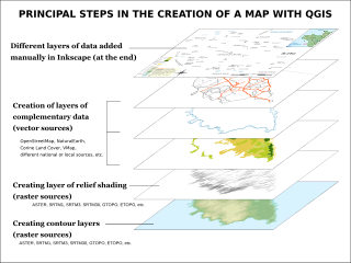
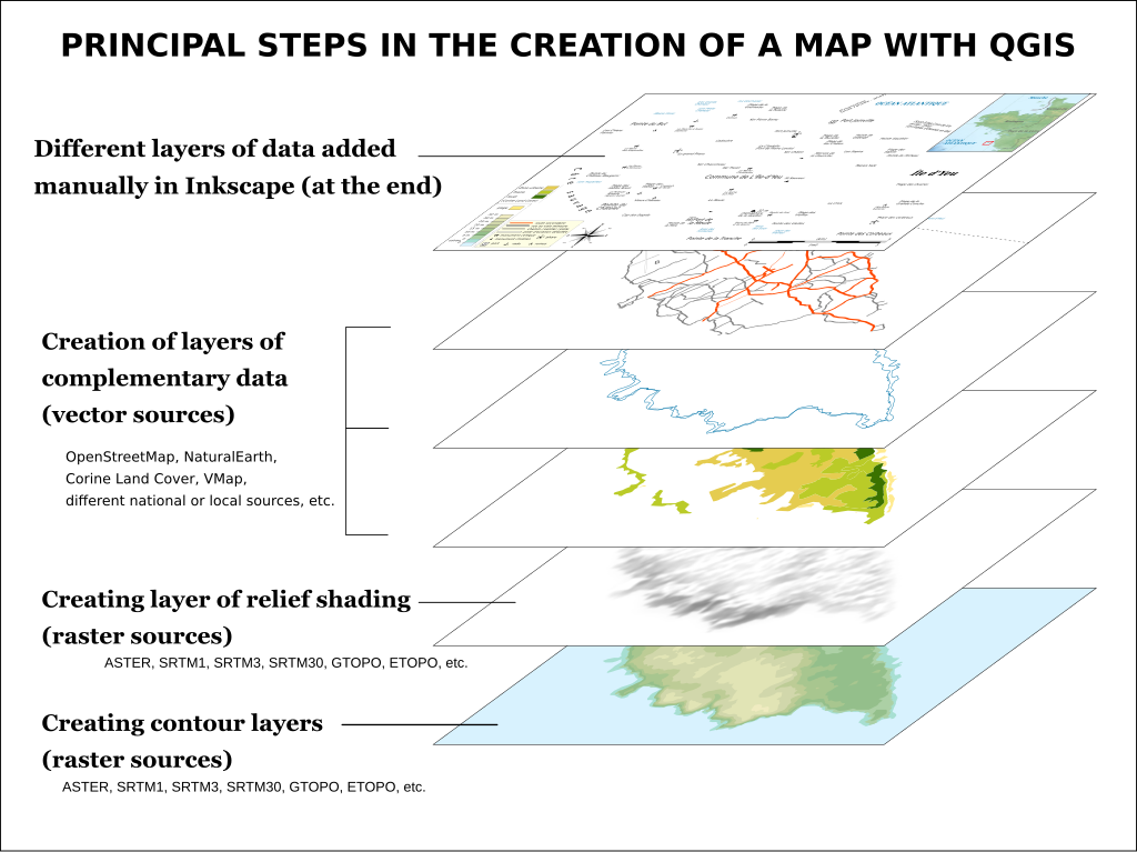
Français : Étapes de création de carte avec QGIS English: Map making steps with QGIS
Deutsch: Prinzip der Kartenerstellung mit Quantum GIS |
||
| Date | (UTC) | ||
| Source |
This file was derived from: Étapes de création de carte avec QGIS.svg: |
||
| Author |
|
||
| SVG development | This diagram was created with Inkscape.
|

Licensing[edit]
I, the copyright holder of this work, hereby publish it under the following license:
This file is licensed under the Creative Commons Attribution-Share Alike 3.0 Unported license.
- You are free:
- to share – to copy, distribute and transmit the work
- to remix – to adapt the work
- Under the following conditions:
- attribution – You must give appropriate credit, provide a link to the license, and indicate if changes were made. You may do so in any reasonable manner, but not in any way that suggests the licensor endorses you or your use.
- share alike – If you remix, transform, or build upon the material, you must distribute your contributions under the same or compatible license as the original.
Original upload log[edit]
This image is a derivative work of the following images:
- File:Étapes_de_création_de_carte_avec_QGIS.svg licensed with Cc-by-sa-3.0
- 2012-08-06T12:24:06Z Bourrichon 2302x1723 (1061115 Bytes) Précision : "divers" calques
- 2012-08-05T23:59:45Z Bourrichon 2302x1723 (1061107 Bytes) bug typo
- 2012-08-05T23:57:57Z Bourrichon 2302x1723 (974478 Bytes)
- 2012-08-05T23:51:15Z Bourrichon 2302x1723 (976223 Bytes) bug
- 2012-08-05T23:48:37Z Bourrichon 2302x1723 (976013 Bytes) +
- 2012-08-05T23:42:44Z Bourrichon 2302x1723 (975374 Bytes)
Uploaded with derivativeFX
File history
Click on a date/time to view the file as it appeared at that time.
| Date/Time | Thumbnail | Dimensions | User | Comment | |
|---|---|---|---|---|---|
| current | 08:04, 4 May 2013 | | 2,302 × 1,723 (2.2 MB) | Citypeek (talk | contribs) | Valid SVG now. |
| 07:42, 4 May 2013 |  | 2,302 × 1,723 (1,005 KB) | Citypeek (talk | contribs) | == {{int:filedesc}} == {{Information |Description={{fr|1=Étapes de création de carte avec QGIS}} {{en|1=Map making steps with QGIS}} {{de|1=Prinzip der Kartenerstellung mit Quantum GIS}} |date=2012-08-06 ... |
You cannot overwrite this file.
File usage on Commons
There are no pages that use this file.
File usage on other wikis
The following other wikis use this file:
- Usage on en.wikipedia.org
- Usage on uk.wikipedia.org