File:Cow Lamarre 2010-04-05.jpg

Original file (2,441 × 3,206 pixels, file size: 3.21 MB, MIME type: image/jpeg)
Captions
Captions
Summary[edit]
| Description |
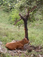
English: Cow of at road side in residential area of the village Lamarre near Sainte-Anne, Grande Terre, Guadeloupe. Cropped from original using GIMP. Probably a cross breed between Guadeloupe Creole Cattle and Limousine. Se email communication below from the INRA specialist of Creole race in Fort-de-France (Guadeloupe.
Français : Bonjour Il est difficile de juger sur la photo, l'animal étant couché, et les seules parties réellement visibles étant le dos et la tête. Il aurait fallu pouvoir avoir une photo sur pied, de la totalité de l'animal (pour voir notamment l'abdomen, les pattes et onglons, et la morphologie d'ensemble de l'animal).
A première vue, l'animal présente quelques caractéristiques de la vache Créole (muqueuses sombres, cornage en coupe, profil de tête droit, oreilles petites et horizontales). Cependant il lui manque un élément caractéristique qui est la bosse de type zébu, très marquée chez le bovin Créole (quoique moins prononcée chez les jeunes femelles), mais qui est totalement absente chez cet animal. De plus le fanon apparait très peu développé et la robe uniformément brune (même s'il est difficile d'en juger vu la position de l'animal). Ces dernières observations me font donc penser qu'il ne s'agit pas d'un animal de race Créole, mais plutot un croisé, éventuellement avec du Limousin. Vous trouverez des illustrations sur notre site : http://www.antilles.inra.fr/antilles/les_recherches/unite_de_recherche_en_productions_animales/adaptation_aux_contraintes_d_elevage/caracterisation_des_populations_locales Bien Cordialement Michel NAVES |
| Date | |
| Source | Own work |
| Author | Kim Hansen |
| Other versions |
|

| Camera location | | View this and other nearby images on: OpenStreetMap |
|---|
Licensing[edit]
- You are free:
- to share – to copy, distribute and transmit the work
- to remix – to adapt the work
- Under the following conditions:
- attribution – You must give appropriate credit, provide a link to the license, and indicate if changes were made. You may do so in any reasonable manner, but not in any way that suggests the licensor endorses you or your use.
- share alike – If you remix, transform, or build upon the material, you must distribute your contributions under the same or compatible license as the original.

|
Permission is granted to copy, distribute and/or modify this document under the terms of the GNU Free Documentation License, Version 1.2 or any later version published by the Free Software Foundation; with no Invariant Sections, no Front-Cover Texts, and no Back-Cover Texts. A copy of the license is included in the section entitled GNU Free Documentation License. |
| Annotations | This image is annotated: View the annotations at Commons |
This image has been assessed using the Quality image guidelines and is considered a Quality image.
|
File history
Click on a date/time to view the file as it appeared at that time.
| Date/Time | Thumbnail | Dimensions | User | Comment | |
|---|---|---|---|---|---|
| current | 20:39, 23 October 2010 | | 2,441 × 3,206 (3.21 MB) | Slaunger (talk | contribs) | {{Information |Description={{Domesticated cow at row side in residential area of the Village Lamarre near Sainte-Anne, Grande Terre, Guadeloupe. Cropped from original using GIMP}} |Source={{own}} |Date=2010-04-05 |Author=Kim Hansen |Perm |
You cannot overwrite this file.
File usage on Commons
The following 8 pages use this file:
- User:Slaunger/France
- User:Slaunger/France/Guadeloupe
- User:Slaunger/France/Guadeloupe/Animals
- User talk:Slaunger/Archives/QIC
- Commons:Quality images/Subject/Animals/Mammals
- Commons:Quality images/Subject/Animals/Mammals/Domesticated
- Commons:Quality images candidates/Archives November 2010
- File:Cow Lamarre 2010-04-05 cropped.jpg
File usage on other wikis
The following other wikis use this file:
- Usage on en.wikipedia.org
- Usage on fr.wikipedia.org