File:County map of Virginia, and North Carolina. LOC lva0000076.jpg
Jump to navigation
Jump to search

Size of this preview: 726 × 600 pixels. Other resolutions: 291 × 240 pixels | 581 × 480 pixels | 930 × 768 pixels | 1,239 × 1,024 pixels | 2,479 × 2,048 pixels | 4,697 × 3,881 pixels.
Original file (4,697 × 3,881 pixels, file size: 4.08 MB, MIME type: image/jpeg)
Captions
Captions
Add a one-line explanation of what this file represents
Summary[edit]
| Description |
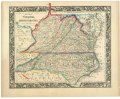
English: "Entered according to act of Congress in the year 1860 by S. Augustus Mitchell, Jr. ... for the Eastern District of Pennsylvania." Map no. 23 from: Mitchell's new general atlas. Philadelphia : S. Augustus Mitchell, Jr., 1860. Prime meridian: Greenwich and Washington. Relief shown by hachures. This item is in the Map Collection of the Library of Virginia; please contact the Library's Archives Research Services department for more information. Available also through the Library of Congress web site as raster image. Dec. 2002; L.S. Straight (Dec. 1970), price unknown ; Map Cataloging Team. Civil War Map Proj. no.: lva00076. Conservation: Etherington Conservation Center, July 2002. Digital image available: 11.25 x 13.25 in. Map accession no. 3058 (1970). Previously filed as: 755 1860. |
||
| Title | County map of Virginia, and North Carolina. | ||
| Shelf ID | https://www.loc.gov/item/lva0000076/ | ||
| Date | |||
| Source | https://www.loc.gov/item/lva0000076/ | ||
| Author | Mitchell, S. Augustus (Samuel Augustus) | ||
| Permission (Reusing this file) |
|
||
| Other versions |
|
||
| Location | United States · Virginia · North Carolina | ||
| Part of | Military Battles And Campaigns · American Memory · Civil War Maps · Geography And Map Division | ||
| Subject | Virginia · Civil War · United States · Maps · North Carolina · History |

Licensing[edit]
|
This is a faithful photographic reproduction of a two-dimensional, public domain work of art. The work of art itself is in the public domain for the following reason:
The official position taken by the Wikimedia Foundation is that "faithful reproductions of two-dimensional public domain works of art are public domain".
This photographic reproduction is therefore also considered to be in the public domain in the United States. In other jurisdictions, re-use of this content may be restricted; see Reuse of PD-Art photographs for details. | ||||
File history
Click on a date/time to view the file as it appeared at that time.
| Date/Time | Thumbnail | Dimensions | User | Comment | |
|---|---|---|---|---|---|
| current | 19:26, 14 May 2018 | | 4,697 × 3,881 (4.08 MB) | Fæ (talk | contribs) | LOC Maps https://www.loc.gov/item/lva0000076/ #72 |
You cannot overwrite this file.
File usage on Commons
The following page uses this file: