File:Counties of Croatia.svg
Jump to navigation
Jump to search

Size of this PNG preview of this SVG file: 619 × 599 pixels. Other resolutions: 248 × 240 pixels | 496 × 480 pixels | 793 × 768 pixels | 1,058 × 1,024 pixels | 2,116 × 2,048 pixels | 1,097 × 1,062 pixels.
Original file (SVG file, nominally 1,097 × 1,062 pixels, file size: 759 KB)
Captions
Captions
Add a one-line explanation of what this file represents
| Description |
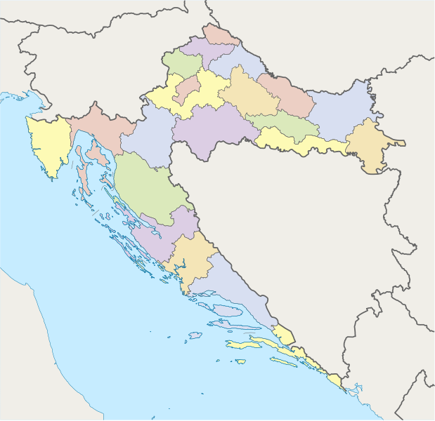
Deutsch: Karte von Kroatien mit Gespanschaften. Quadratische Plattkarte, N-S-Streckung 140 %. Geographische Begrenzung der Karte: * N: 46.8° N * S: 42.1° N * W: 13.1° O * O: 19.9° O English: Map of Croatia with counties. Equirectangular projection, N/S stretching 140 %. Geographic limits of the map: * N: 46.8° N * S: 42.1° N * W: 13.1° E * E: 19.9° E |
| Date | (UTC) |
| Source | |
| Author |
|
| Other versions | Derivative works of this file: Counties of Croatia-fr.svg |
| This is a retouched picture, which means that it has been digitally altered from its original version. The original can be viewed here: Croatia location map.svg:
|
I, the copyright holder of this work, hereby publish it under the following licenses:
This file is licensed under the Creative Commons Attribution-Share Alike 3.0 Unported license.
- You are free:
- to share – to copy, distribute and transmit the work
- to remix – to adapt the work
- Under the following conditions:
- attribution – You must give appropriate credit, provide a link to the license, and indicate if changes were made. You may do so in any reasonable manner, but not in any way that suggests the licensor endorses you or your use.
- share alike – If you remix, transform, or build upon the material, you must distribute your contributions under the same or compatible license as the original.

|
Permission is granted to copy, distribute and/or modify this document under the terms of the GNU Free Documentation License, Version 1.2 or any later version published by the Free Software Foundation; with no Invariant Sections, no Front-Cover Texts, and no Back-Cover Texts. A copy of the license is included in the section entitled GNU Free Documentation License. |
You may select the license of your choice.
Original upload log[edit]
This image is a derivative work of the following images:
- Image:Croatia_location_map.svg licensed with Cc-by-sa-3.0, GFDL
- 2008-08-29T08:00:53Z NordNordWest 1097x1062 (491312 Bytes) '
- 2008-07-30T15:54:56Z NordNordWest 548x531 (421799 Bytes) more detailed borderlines
- 2008-07-16T16:55:30Z NordNordWest 548x531 (465194 Bytes) {{Information |Description= {{de|Positionskarte von [[:de:Kroatien|Kroatien]]}} Quadratische Plattkarte, N-S-Streckung 140 %. Geographische Begrenzung der Karte: * N: 46.8° N * S: 42.1° N * W: 13.1° O * O: 19.9° O {{en|Lo
Uploaded with derivativeFX
File history
Click on a date/time to view the file as it appeared at that time.
| Date/Time | Thumbnail | Dimensions | User | Comment | |
|---|---|---|---|---|---|
| current | 15:56, 11 September 2008 | | 1,097 × 1,062 (759 KB) | Minestrone (talk | contribs) | {{Information |Description= |Source= |Date= |Author= |Permission= |other_versions= }} |
| 15:00, 8 September 2008 |  | 1,097 × 1,062 (759 KB) | Minestrone (talk | contribs) | {{Information |Description={{de|Karte von Kroatien}} mit Gespanschaften. Quadratische Plattkarte, N-S-Streckung 140 %. Geographische Begrenzung der Karte: * N: 46.8° N * S: 42.1° N * W: 13.1° O * O: 19.9° O {{en|Map of [[:en:Croatia|C |
You cannot overwrite this file.
File usage on Commons
The following 2 pages use this file:
File usage on other wikis
The following other wikis use this file:
- Usage on ar.wikipedia.org
- قالب:قائمة اليوم المختارة/2015-06-21
- ويكيبيديا:قائمة اليوم المختارة/يونيو 2015
- ويكيبيديا:قائمة اليوم المختارة/أغسطس 2015
- قالب:قائمة اليوم المختارة/2015-08-08
- قالب:قائمة اليوم المختارة/2015-08-10
- ويكيبيديا:قائمة اليوم المختارة/أكتوبر 2015
- قالب:قائمة اليوم المختارة/2015-10-11
- ويكيبيديا:قائمة اليوم المختارة/ديسمبر 2015
- قالب:قائمة اليوم المختارة/2015-12-17
- ويكيبيديا:قائمة اليوم المختارة/فبراير 2016
- قالب:قائمة اليوم المختارة/2016-02-29
- ويكيبيديا:قائمة اليوم المختارة/مايو 2016
- قالب:قائمة اليوم المختارة/2016-05-25
- ويكيبيديا:قائمة اليوم المختارة/يوليو 2016
- قالب:قائمة اليوم المختارة/2016-07-29
- ويكيبيديا:قائمة اليوم المختارة/ديسمبر 2016
- قالب:قائمة اليوم المختارة/2016-12-10
- ويكيبيديا:قائمة اليوم المختارة/يناير 2017
- قالب:قائمة اليوم المختارة/2017-01-26
- ويكيبيديا:قائمة اليوم المختارة/أبريل 2017
- قالب:قائمة اليوم المختارة/2017-04-21
- بوابة:تجمعات سكانية/قائمة مختارة
- بوابة:تجمعات سكانية/قائمة مختارة/7
- ويكيبيديا:قائمة اليوم المختارة/يونيو 2017
- قالب:قائمة اليوم المختارة/2017-06-30
- ويكيبيديا:قائمة اليوم المختارة/أكتوبر 2017
- قالب:قائمة اليوم المختارة/2017-10-20
- ويكيبيديا:قائمة اليوم المختارة/نوفمبر 2017
- قالب:قائمة اليوم المختارة/2017-11-25
- ويكيبيديا:قائمة اليوم المختارة/يناير 2018
- قالب:قائمة اليوم المختارة/2018-01-04
- ويكيبيديا:قائمة اليوم المختارة/فبراير 2018
- قالب:قائمة اليوم المختارة/2018-02-27
- ويكيبيديا:قائمة اليوم المختارة/سبتمبر 2018
- قالب:قائمة اليوم المختارة/2018-09-22
- ويكيبيديا:قائمة اليوم المختارة/أبريل 2019
- قالب:قائمة اليوم المختارة/2019-04-17
- ويكيبيديا:قائمة اليوم المختارة/أكتوبر 2019
- قالب:قائمة اليوم المختارة/2019-10-07
- ويكيبيديا:قائمة اليوم المختارة/مارس 2020
- قالب:قائمة اليوم المختارة/2020-03-27
- ويكيبيديا:قائمة اليوم المختارة/فبراير 2021
- قالب:قائمة اليوم المختارة/2021-02-28
- ويكيبيديا:قائمة اليوم المختارة/أبريل 2022
- قالب:قائمة اليوم المختارة/2022-04-16
- ويكيبيديا:قائمة اليوم المختارة/ديسمبر 2022
- قالب:قائمة اليوم المختارة/2022-12-04
- ويكيبيديا:قائمة اليوم المختارة/يوليو 2023
- قالب:قائمة اليوم المختارة/2023-07-26
- ويكيبيديا:قائمة اليوم المختارة/مارس 2024
View more global usage of this file.