File:Corp of Eng. 6-16-11A 267.JPG
Jump to navigation
Jump to search

Size of this preview: 800 × 536 pixels. Other resolutions: 320 × 214 pixels | 640 × 428 pixels | 1,024 × 685 pixels | 1,280 × 857 pixels | 2,560 × 1,714 pixels | 3,872 × 2,592 pixels.
Original file (3,872 × 2,592 pixels, file size: 4.68 MB, MIME type: image/jpeg)
Captions
Captions
Add a one-line explanation of what this file represents
Summary[edit]
| Description |
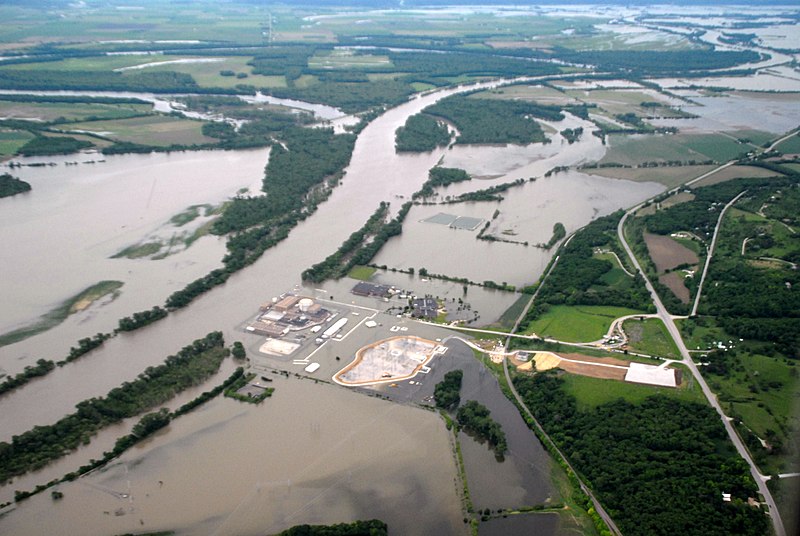
English: Aerial view of Fort Calhoun Nuclear Reactor during 2011 Missouri River Flood on June 16, 2011 . 8' tall water-filled flood barriers were placed around vital buildings for perimeter flood protection. |
| Date | |
| Source | http://www.nwo.usace.army.mil/html/op-e/Photos/Mo%20River%20Rulo%20to%20Blair%2016%20June%202011/NE-Blair-Omaha.pdf |
| Author | U.S. Army Corps of Engineer |
| Camera location | | View this and other nearby images on: OpenStreetMap |
|---|
Licensing[edit]
This file is a work of a U.S. Army soldier or employee, taken or made as part of that person's official duties. As a work of the U.S. federal government, it is in the public domain in the United States.
|
 |
File history
Click on a date/time to view the file as it appeared at that time.
| Date/Time | Thumbnail | Dimensions | User | Comment | |
|---|---|---|---|---|---|
| current | 03:28, 22 June 2011 | | 3,872 × 2,592 (4.68 MB) | Americasroof (talk | contribs) | {{Information |Description ={{en|1=Aerial view of Fort Calhoun Nuclear Reactor during 2011 Missouri River Flood on June 16, 2011}} |Source =http://www.nwo.usace.army.mil/html/op-e/Photos/Mo%20River%20Rulo%20to%20Blair%2016%20June%202011/NE-Blai |
You cannot overwrite this file.
File usage on Commons
There are no pages that use this file.
File usage on other wikis
The following other wikis use this file:
- Usage on ar.wikipedia.org
- Usage on ast.wikipedia.org
- Usage on br.wikipedia.org
- Usage on de.wikipedia.org
- Usage on de.wikinews.org
- Usage on en.wikipedia.org
- Usage on en.wikinews.org
- Usage on es.wikipedia.org
- Usage on fi.wikipedia.org
- Usage on fr.wikipedia.org
- Usage on fr.wikinews.org
- Usage on gl.wikipedia.org
- Usage on it.wikipedia.org
- Usage on ja.wikipedia.org
- Usage on ru.wikipedia.org
- Usage on ta.wikipedia.org
- Usage on th.wikipedia.org