File:Copenhagen Metro with City Circle Line map.svg
Jump to navigation
Jump to search

Size of this PNG preview of this SVG file: 512 × 335 pixels. Other resolutions: 320 × 209 pixels | 640 × 419 pixels | 1,024 × 670 pixels | 1,280 × 838 pixels | 2,560 × 1,675 pixels.
Original file (SVG file, nominally 512 × 335 pixels, file size: 27 KB)
Captions
Captions
Add a one-line explanation of what this file represents
| Description |
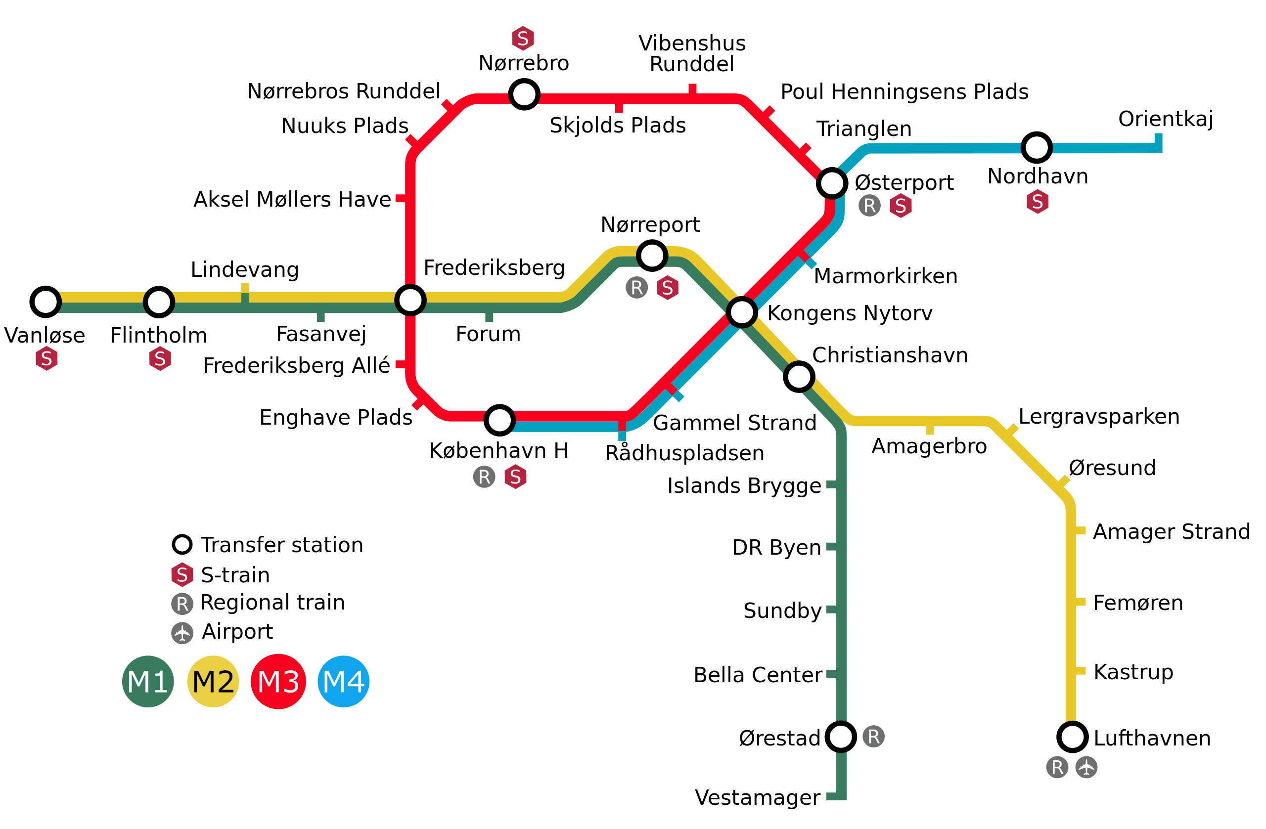
A map of the Copenhagen Metro with the City Circle Line intended to open in 2019 and the Nordhavn extension intended to open in 2020. Colours: M1=007F60, M2=FEC20F, M3=F8001F, M4=00A0BE |
| Date | (UTC) |
| Source | |
| Author |
|
I, the copyright holder of this work, hereby publish it under the following licenses:
This file is licensed under the Creative Commons Attribution-Share Alike 3.0 Unported, 2.5 Generic, 2.0 Generic and 1.0 Generic license.
- You are free:
- to share – to copy, distribute and transmit the work
- to remix – to adapt the work
- Under the following conditions:
- attribution – You must give appropriate credit, provide a link to the license, and indicate if changes were made. You may do so in any reasonable manner, but not in any way that suggests the licensor endorses you or your use.
- share alike – If you remix, transform, or build upon the material, you must distribute your contributions under the same or compatible license as the original.

|
Permission is granted to copy, distribute and/or modify this document under the terms of the GNU Free Documentation License, Version 1.2 or any later version published by the Free Software Foundation; with no Invariant Sections, no Front-Cover Texts, and no Back-Cover Texts. A copy of the license is included in the section entitled GNU Free Documentation License. |
You may select the license of your choice.
Original upload log[edit]
This image is a derivative work of the following images:
- File:KøbenhavnMetroKort+Cityringen_English.svg licensed with Cc-by-sa-3.0,2.5,2.0,1.0, GFDL
- 2009-11-08T23:44:29Z Arsenikk 725x475 (84138 Bytes) Plain svg
- 2009-04-13T12:00:31Z Arsenikk 725x475 (84138 Bytes) {{Information |Description=A map of the Copenhagen Metro with the proposed City Circle Line intended to open in 2017–2018. |Source=*[[:File:KøbenhavnMetroKort+Cityringen.svg|]] |Date=2009-04-13 12:59 (UTC) |Author=*[[:File
Uploaded with derivativeFX
File history
Click on a date/time to view the file as it appeared at that time.
| Date/Time | Thumbnail | Dimensions | User | Comment | |
|---|---|---|---|---|---|
| current | 08:25, 1 October 2019 | | 512 × 335 (27 KB) | Valentinian (talk | contribs) | M3. Updating to the same logo as used on the stations. |
| 08:12, 14 July 2019 |  | 512 × 335 (27 KB) | Valentinian (talk | contribs) | Updating logos line and line colours. See https://m.dk/ | |
| 19:51, 20 August 2013 |  | 512 × 335 (18 KB) | AB-me (talk | contribs) | swapped colours of M3 and M4 | |
| 22:40, 10 June 2013 |  | 512 × 335 (18 KB) | Ysangkok (talk | contribs) | new stations (Orientkaj, Nordhavn) | |
| 19:51, 15 June 2011 |  | 725 × 475 (474 KB) | Arsenikk (talk | contribs) | Frederiksborg Allé changed to Frederiksberg Allé | |
| 17:06, 26 January 2010 |  | 725 × 475 (476 KB) | Arsenikk (talk | contribs) | Convert text to path | |
| 17:01, 26 January 2010 |  | 725 × 475 (129 KB) | Arsenikk (talk | contribs) | New station names and updated legend | |
| 11:13, 18 November 2009 |  | 725 × 475 (354 KB) | Tryphon (talk | contribs) | Trying to remove the black line. | |
| 11:28, 17 November 2009 |  | 725 × 475 (468 KB) | Arsenikk (talk | contribs) | {{Information |Description=A map of the Copenhagen Metro with the proposed City Circle Line intended to open in 2018. |Source=*File:KøbenhavnMetroKort+Cityringen_English.svg |Date=2009-11-17 11:27 (UTC) |Author=*[[:File:KøbenhavnMetroKort+Cityring |
You cannot overwrite this file.
File usage on Commons
The following 11 pages use this file:
- User:Chumwa/OgreBot/Potential transport maps/2019 July 11-20
- User:Chumwa/OgreBot/Potential transport maps/2019 October 1-10
- User:Chumwa/OgreBot/Public transport information/2019 July 11-20
- User:Chumwa/OgreBot/Public transport information/2019 October 1-10
- User:Chumwa/OgreBot/Transport Maps/2019 July 11-20
- User:Chumwa/OgreBot/Transport Maps/2019 October 1-10
- User:Chumwa/OgreBot/Travel and communication maps/2019 July 11-20
- User:Chumwa/OgreBot/Travel and communication maps/2019 October 1-10
- User talk:Arsenikk
- Category:City Circle Line
- Category:Copenhagen Metro
File usage on other wikis
The following other wikis use this file:
- Usage on az.wikipedia.org
- Usage on ca.wikipedia.org
- Usage on da.wikipedia.org
- Usage on de.wikipedia.org
- Usage on de.wikiversity.org
- Usage on en.wikipedia.org
- Usage on es.wikipedia.org
- Usage on fi.wikipedia.org
- Usage on it.wikipedia.org
- Usage on ja.wikipedia.org
- Usage on ko.wikipedia.org
- Usage on lmo.wikipedia.org
- Usage on nl.wikipedia.org
- Usage on nn.wikipedia.org
- Usage on no.wikipedia.org
- Usage on pl.wikipedia.org
- Usage on ru.wikipedia.org
- Usage on sv.wikipedia.org
- Usage on tr.wikipedia.org
- Usage on tt.wikipedia.org
- Usage on uk.wikipedia.org
- Usage on www.wikidata.org