File:Controlled airspaces.png
Jump to navigation
Jump to search

Size of this preview: 800 × 291 pixels. Other resolutions: 320 × 116 pixels | 640 × 233 pixels | 1,024 × 372 pixels | 1,280 × 465 pixels | 2,560 × 931 pixels | 10,826 × 3,937 pixels.
Original file (10,826 × 3,937 pixels, file size: 1.57 MB, MIME type: image/png)
Captions
Captions
Add a one-line explanation of what this file represents
Summary[edit]
| Description |
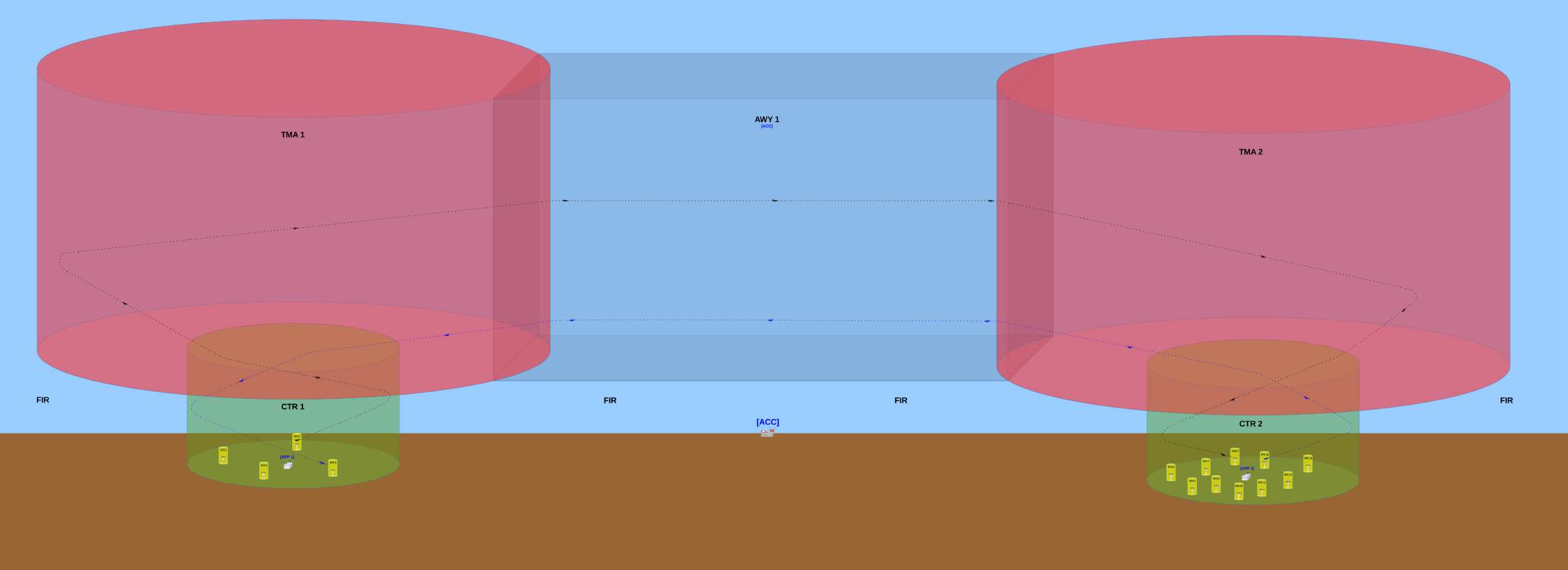
English: Basic configuration of the controlled airspaces and their respective air traffic control offices.
The TWR (aerodrome control tower) usually controls traffic that occurs inside the ATZ (aerodrome traffic zone) of the aerodrome where this TWR is installed at. The APP (approach control) usually controls traffic that occurs inside the CTR (control zone) but outside of the ATZs. The APP also controls traffic ocurring inside the TMA (terminal control area). The ACC (area control centre) usually controls traffic occurring inside any AWY (airway). In this image, the surrounding airspace (outside of the ATZs, CTRs, TMAs and AWY) is a non-controlled airspace designated a Flight Information Region (FIR). When an aircraft is flying into a FIR, no Air Traffic Control (ATC) office will provide any traffic control to this aircraft's pilot(s), however the ACC will provide it the Flight Information Service (FIS) and the Alerting Service (ALRS). Português: Configuração básica dos espaços aéreos controlados e seus respectivos órgãos de controle de tráfego aéreo.
A TWR (torre de controle de aeródromo) geralmente controla o tráfego que ocorre dentro da ATZ (Aerodrome Traffic Zone / Zona de Tráfego de Aeródromo) do aeródromo no qual essa TWR está instalada. O APP (Approach Control / Controle de Aproximação) geralmente controla o tráfego que ocorre dentro da CTR (Control Zone / Zona de Controle) mas que está fora das ATZ. O APP também controla o tráfego que ocorre dentro da TMA (Terminal Control Area / Área de Controle Terminal). O ACC (Area Control Centre / Centro de Controle de Área) geralmente controla o tráfego que ocorre dentro de qualquer AWY (Airway / Aerovia). Nesta imagem, o espaço aéreo ao redor (fora das ATZ, CTR, TMA e AWY) é um espaço aéreo não controlado denominado FIR (Flight Information Region / Região de Informação de Voo). Quando uma aeronave está voando dentro de uma FIR, nenhum órgão ATC (órgão de Air Traffic Control / Controle de Tráfego Aéreo) irá prover qualquer tipo de controle de tráfego para o(s) piloto(s) dessa aeronave, porém o ACC irá prover a esse(s) piloto(s) o FIS (Flight Information Service / Serviço de Informação de Voo) e o ALRS (Alerting Service / Serviço de Alerta). |
| Date | |
| Source | Own work |
| Author | Yuri Ribeiro Sucupira |
| Permission (Reusing this file) |
English: See license below. Attribution: when using this image, please provide a link to this page. As an alternative to providing a link, you can inform my full name (Yuri Ribeiro Sucupira) along with the license (see below). Português: Veja a licença abaixo. Atribuição: ao usar esta imagem, basta incluir uma ligação que aponte para esta página. Alternativamente, ao invés de fornecer um link você pode informar meu nome completo (Yuri Ribeiro Sucupira) juntamente com a licença (vide abaixo). |
| Other versions |
English: The first version uploaded was quite different from the most up-to-date version and must not be used, mostly because it has a conceptual error: the inferior limit of the CTRs are above the Earth's surface, which is wrong because the inferior limit of a CTR must always be the Earth's surface. Português: A primeira versão incluída era consideravelmente diferente da versão mais atual deste desenho e não deve ser usada, principalmente porque essa primeira versão tem um erro conceitual: o limite inferior das duas CTR está acima do nível da superfície terrestre, mas isso está errado porque o limite inferior de uma CTR deve sempre ser a superfície terrestre. |
| Camera location | | View this and other nearby images on: OpenStreetMap |
|---|
Licensing[edit]
I, the copyright holder of this work, hereby publish it under the following license:
This file is licensed under the Creative Commons Attribution-Share Alike 3.0 Unported license.
- You are free:
- to share – to copy, distribute and transmit the work
- to remix – to adapt the work
- Under the following conditions:
- attribution – You must give appropriate credit, provide a link to the license, and indicate if changes were made. You may do so in any reasonable manner, but not in any way that suggests the licensor endorses you or your use.
- share alike – If you remix, transform, or build upon the material, you must distribute your contributions under the same or compatible license as the original.
File history
Click on a date/time to view the file as it appeared at that time.
| Date/Time | Thumbnail | Dimensions | User | Comment | |
|---|---|---|---|---|---|
| current | 21:39, 12 March 2014 | 10,826 × 3,937 (1.57 MB) | Sampayu (talk | contribs) | Improvement: added some objects (airplanes and towers) that were missing mostly on the right side of the picture. | |
| 20:39, 11 March 2014 | 10,568 × 3,630 (1.27 MB) | Sampayu (talk | contribs) | This new version has more detailed visual informations and the file size is smaller, which makes it more didactic and is good to help Wikipedia articles and internet pages in general load faster when they have this image embedded in them. The previou... | ||
| 09:15, 8 March 2014 | 3,550 × 1,185 (16.07 MB) | Sampayu (talk | contribs) | User created page with UploadWizard |
You cannot overwrite this file.
File usage on Commons
The following page uses this file:
File usage on other wikis
The following other wikis use this file:
- Usage on ar.wikipedia.org
- Usage on en.wikipedia.org
- Usage on fa.wikipedia.org
- Usage on id.wikipedia.org
- Usage on pt.wikipedia.org