File:Contrasting Ridges in Virginia.jpg
Jump to navigation
Jump to search

Size of this preview: 800 × 533 pixels. Other resolutions: 320 × 213 pixels | 640 × 427 pixels | 1,024 × 683 pixels | 1,280 × 853 pixels | 3,000 × 2,000 pixels.
Original file (3,000 × 2,000 pixels, file size: 5.17 MB, MIME type: image/jpeg)
Captions
Captions
Add a one-line explanation of what this file represents
Summary[edit]
| Description |
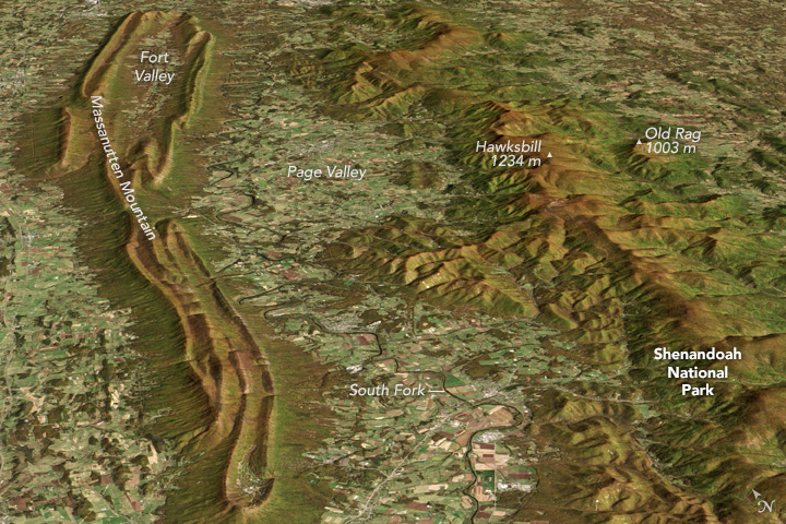
English: Image displaying the topographical differences between two roughly parallel ridges along Virginia's western border: one is the backbone of Shenandoah National Park, and the other is part of George Washington National Forest, both rise above the Shenandoah Valley's rolling lowlands. |
| Date | |
| Source |
https://www.earthobservatory.nasa.gov/IOTD/view.php?id=89843&eocn=related_to&eoci=related_image https://eoimages.gsfc.nasa.gov/images/imagerecords/89000/89843/shenandoah_oli_2013294.jpg |
| Author |
NASA Earth Observatory image by Jesse Allen, using Landsat data from the U.S. Geological Survey and ASTER GDM2 terrain data from NASA/GSFC/METI/ERSDAC/JAROS, and U.S./Japan ASTER Science Team. Caption by Adam Voiland. Instrument(s): Terra - ASTER Landsat 8 - OLI |
Licensing[edit]
| This file is in the public domain in the United States because it was solely created by NASA. NASA copyright policy states that "NASA material is not protected by copyright unless noted". (See Template:PD-USGov, NASA copyright policy page or JPL Image Use Policy.) | ||
 |
Warnings:
|
File history
Click on a date/time to view the file as it appeared at that time.
| Date/Time | Thumbnail | Dimensions | User | Comment | |
|---|---|---|---|---|---|
| current | 22:24, 27 November 2017 | | 3,000 × 2,000 (5.17 MB) | Jalbertbowdenii (talk | contribs) | User created page with UploadWizard |
You cannot overwrite this file.
File usage on Commons
There are no pages that use this file.