File:Constantia Nek.JPG
Jump to navigation
Jump to search

Size of this preview: 800 × 600 pixels. Other resolutions: 320 × 240 pixels | 640 × 480 pixels | 1,024 × 768 pixels | 1,280 × 960 pixels | 2,592 × 1,944 pixels.
Original file (2,592 × 1,944 pixels, file size: 2.21 MB, MIME type: image/jpeg)
Captions
Captions
Add a one-line explanation of what this file represents
Summary[edit]
| Description |
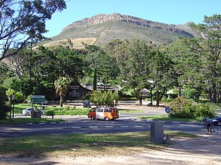
English: Intersection at Constantia Nek in Cape Town, showing Constantia Nek restaurant and Vlakkenberg to the south. Constantia Nek is one of three passes connecting Hout Bay to the rest of Cape Town. |
| Date | |
| Source | Own work |
| Author | Zaian |
| Camera location | | View this and other nearby images on: OpenStreetMap |
|---|
Licensing[edit]
| I, the copyright holder of this work, release this work into the public domain. This applies worldwide. In some countries this may not be legally possible; if so: I grant anyone the right to use this work for any purpose, without any conditions, unless such conditions are required by law. |
File history
Click on a date/time to view the file as it appeared at that time.
| Date/Time | Thumbnail | Dimensions | User | Comment | |
|---|---|---|---|---|---|
| current | 13:20, 31 December 2009 | | 2,592 × 1,944 (2.21 MB) | Zaian (talk | contribs) | {{Information |Description={{en|1=Intersection at Constantia Nek in Cape Town, showing Constantia Nek restaurant and Vlakkenberg to the south. Constantia Nek is one of three passes connecting Hout Bay to the rest of Cape Town.}} |Source={{own}} |Author=[[ |
You cannot overwrite this file.
File usage on Commons
There are no pages that use this file.
File usage on other wikis
The following other wikis use this file:
- Usage on af.wikipedia.org
- Usage on en.wikipedia.org
- Usage on fr.wikipedia.org
- Usage on www.wikidata.org