File:CongoCrisis Map.svg
Jump to navigation
Jump to search

Size of this PNG preview of this SVG file: 593 × 600 pixels. Other resolutions: 237 × 240 pixels | 475 × 480 pixels | 760 × 768 pixels | 1,013 × 1,024 pixels | 2,026 × 2,048 pixels | 637 × 644 pixels.
Original file (SVG file, nominally 637 × 644 pixels, file size: 168 KB)
Captions
Captions
Add a one-line explanation of what this file represents
Summary[edit]
| Description |
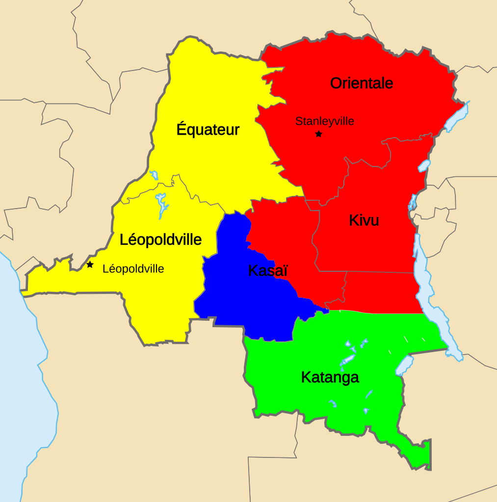
English (en): Map of Territorial Control during the Congo Crisis (1960-61).
National Government based in Léopoldville Rival National Government based in Stanleyville Katanga (Independent) Mining State of South Kasai (Autonomous)
Created with the GIMP; Made by User:Acntx == |
| Date | (UTC) |
| Source | |
| Author |
|
| This is a retouched picture, which means that it has been digitally altered from its original version. The original can be viewed here: Congo Kinshasa Template.svg:
|

|
This SVG file contains embedded text that can be translated into your language, using any capable SVG editor, text editor or the SVG Translate tool. For more information see: About translating SVG files. |
This file is licensed under the Creative Commons Attribution-Share Alike 3.0 Unported license.
- You are free:
- to share – to copy, distribute and transmit the work
- to remix – to adapt the work
- Under the following conditions:
- attribution – You must give appropriate credit, provide a link to the license, and indicate if changes were made. You may do so in any reasonable manner, but not in any way that suggests the licensor endorses you or your use.
- share alike – If you remix, transform, or build upon the material, you must distribute your contributions under the same or compatible license as the original.
Original upload log[edit]
This image is a derivative work of the following images:
- File:Congo_CrisisMap.png licensed with Cc-by-sa-3.0-migrated-with-disclaimers, GFDL-en
- 2010-08-10T13:57:01Z Beao 440x404 (11149 Bytes) Transparent.
- 2006-10-09T17:13:25Z Kelovy 440x404 (10193 Bytes) == Opis súboru == Map of Territorial Control during the Congo Crisis (1960-61). Color Key *'''Yellow''': National Government based in Léopoldville *'''Red''': Rival National Government based in Stanleyville *'''Green''':
- File:Congo_Kinshasa_Template.svg licensed with Cc-by-sa-2.5,2.0,1.0, Cc-by-sa-3.0-migrated, GFDL
- 2006-07-13T08:49:51Z Moyogo 640x647 (270716 Bytes) Lualaba province is Lualaba district + Kolwezi-city district
- 2006-05-28T19:43:22Z Moyogo 640x647 (268950 Bytes) split into layers, added provinces of 1960, 1966 and 1988.
- 2006-05-26T14:57:57Z Moyogo 640x647 (180669 Bytes) improvements to the template: added border of neighbouring countries, provinces' border are uniform, colours drawn from other maps on WP.
- 2005-09-30T10:36:59Z Moyogo 650x650 (117305 Bytes) Template for Province or District maps for the Congo Kinshasa. Each province has an ID in the form Province with the name, e.g. ProvinceKatanga The Provinces are only the outline stroke, no filling Each district has an ID i
Uploaded with derivativeFX
File history
Click on a date/time to view the file as it appeared at that time.
| Date/Time | Thumbnail | Dimensions | User | Comment | |
|---|---|---|---|---|---|
| current | 23:46, 6 March 2011 | | 637 × 644 (168 KB) | Ras67 (talk | contribs) | cropped |
| 01:41, 6 December 2010 |  | 640 × 647 (219 KB) | Themightyquill (talk | contribs) | removed equator line | |
| 01:23, 6 December 2010 |  | 640 × 647 (220 KB) | Themightyquill (talk | contribs) | {{Information |Description=Map of Territorial Control during the Congo Crisis (1960-61). Color Key Yellow: National Government based in Léopoldville Red: Rival National Government based in Stanleyville Green: Katanga (Independent) Blue: Mining State o |
You cannot overwrite this file.
File usage on Commons
The following page uses this file:
File usage on other wikis
The following other wikis use this file:
- Usage on ca.wikipedia.org
- Usage on ja.wikipedia.org
- Usage on www.wikidata.org