File:Comparison satellite navigation orbits-ru.svg
Jump to navigation
Jump to search

Size of this PNG preview of this SVG file: 512 × 512 pixels. Other resolutions: 240 × 240 pixels | 480 × 480 pixels | 768 × 768 pixels | 1,024 × 1,024 pixels | 2,048 × 2,048 pixels.
Original file (SVG file, nominally 512 × 512 pixels, file size: 54 KB)
Captions
Captions
Add a one-line explanation of what this file represents

|
This image is an animated SVG file. The .png preview above created by RSVG for use in Wikimedia is not animated and may be incomplete or incorrect. To see the animation, open media:Comparison satellite navigation orbits-ru.svg. It should run in any modern browser or viewer. Recent versions of Chrome, Firefox, Microsoft Edge, Safari, and Opera all support SVG animated with SMIL.
Other SVG animations can be found at Category:Animated SVG files.
|
Summary[edit]
| Description |
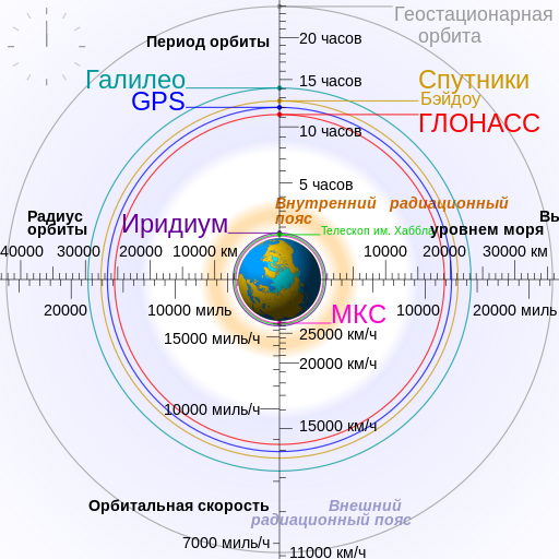
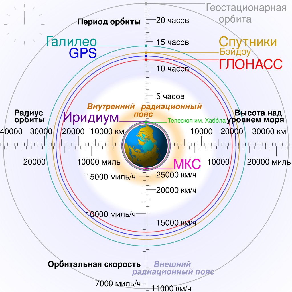
Русский: Сравнение орбит GPS, ГЛОНАСС, Галилео и Бэйдоу с орбитами Международной космической станции, телескопа им. Хаббла и геостационарной орбитой относительно номинального размера Земли. |
| Date | |
| Source |
This file was derived from: Comparison satellite navigation orbits.svg |
| Author | Kirill Borisenko |
| Other versions |
[] English: Animated Español: Animada Македонски: Анимирано Русский: Мультипликация Українська: Анімація
English: Static Македонски: Обична слика Русский: Обычная картинка Українська: Статичне зображення
|


Licensing[edit]
I, the copyright holder of this work, hereby publish it under the following license:
This file is licensed under the Creative Commons Attribution-Share Alike 4.0 International license.
- You are free:
- to share – to copy, distribute and transmit the work
- to remix – to adapt the work
- Under the following conditions:
- attribution – You must give appropriate credit, provide a link to the license, and indicate if changes were made. You may do so in any reasonable manner, but not in any way that suggests the licensor endorses you or your use.
- share alike – If you remix, transform, or build upon the material, you must distribute your contributions under the same or compatible license as the original.
File history
Click on a date/time to view the file as it appeared at that time.
| Date/Time | Thumbnail | Dimensions | User | Comment | |
|---|---|---|---|---|---|
| current | 13:35, 20 March 2022 | | 512 × 512 (54 KB) | Erelen~ruwiki (talk | contribs) | Ссылки внутри на русскоязычную wiki |
| 18:12, 30 July 2018 |  | 512 × 512 (54 KB) | Kirill Borisenko (talk | contribs) | MPH. | |
| 21:40, 28 May 2018 |  | 512 × 512 (54 KB) | Kirill Borisenko (talk | contribs) | Text size correction. | |
| 20:55, 28 May 2018 |  | 512 × 512 (53 KB) | Kirill Borisenko (talk | contribs) | User created page with UploadWizard |
You cannot overwrite this file.
File usage on Commons
The following 10 pages use this file:
- User:Magog the Ogre/Multilingual legend/2022 March 11-20
- Commons:WikiProject Aviation/recent uploads/2018 July 30
- Commons:WikiProject Aviation/recent uploads/2018 May 28
- File:Comparison of several satellite navigation system orbits-ru.svg (file redirect)
- File:Comparison of several satellite navigation system orbits-uk.svg
- File:Comparison satellite navigation orbits-es.svg
- File:Comparison satellite navigation orbits-mk.svg
- File:Comparison satellite navigation orbits-ru.svg
- File:Comparison satellite navigation orbits.svg
- Template:Other versions/Comparison satellite navigation orbits
File usage on other wikis
The following other wikis use this file:
- Usage on be.wikipedia.org
- Usage on bg.wikipedia.org
- Usage on cv.wikipedia.org
- Usage on kk.wikipedia.org
- Usage on ru.wikipedia.org
- Usage on ru.wikinews.org
- Usage on tg.wikipedia.org
- Usage on tt.wikipedia.org
- Usage on uz.wikipedia.org