File:Columbia River Mouth and Bar.jpg
Jump to navigation
Jump to search
Size of this preview: 800 × 517 pixels. Other resolutions: 320 × 207 pixels | 640 × 414 pixels | 1,024 × 662 pixels | 1,280 × 827 pixels | 2,560 × 1,654 pixels | 3,957 × 2,557 pixels.
Original file (3,957 × 2,557 pixels, file size: 4.04 MB, MIME type: image/jpeg)
Captions
Captions
Add a one-line explanation of what this file represents
Summary[edit]
| Description |
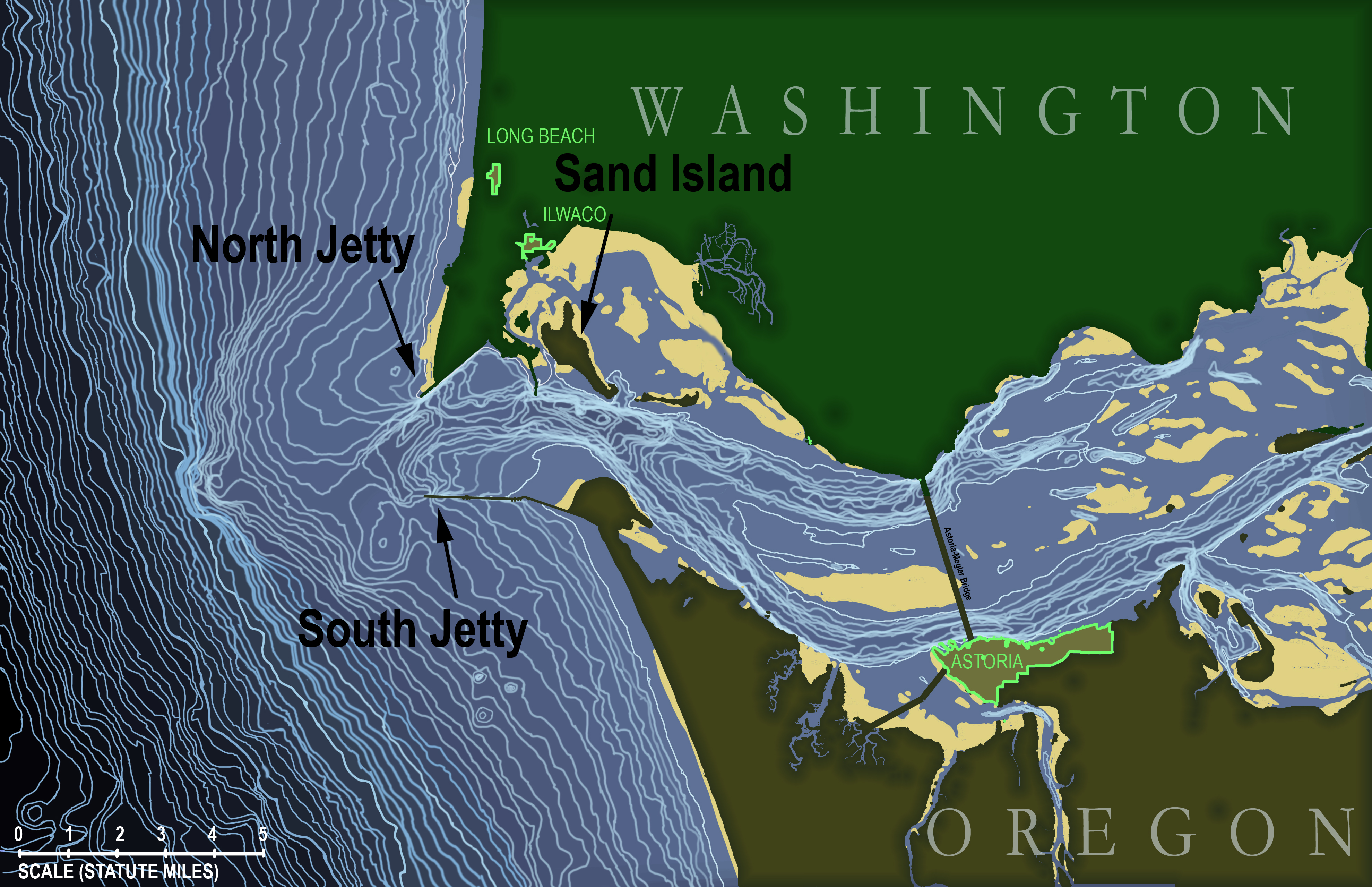
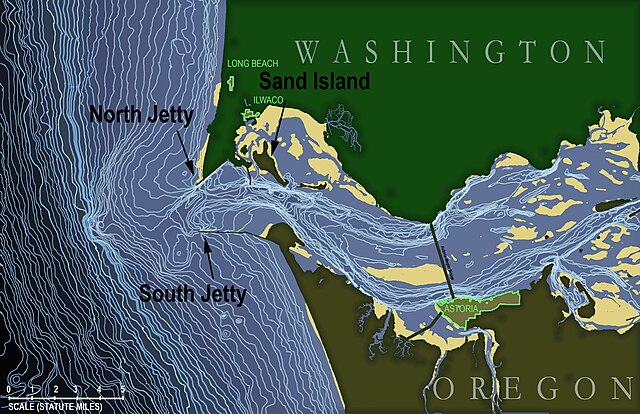
English: Topographic map of the underwater area in and around the mouth of the Columbia River in the state of Oregon, USA. Map is based on soundings in feet taken by the National Oceanic and Atmospheric Administration and published in NOAA navigational chart #18521, "Columbia River - Pacific Ocean to Harrington Point", August 2009 (original chart available here: http://www.charts.noaa.gov/OnLineViewer/18521.shtml) which itself is a public domain image.
Topographic lines on this map begin at a depth of 15 feet and occur at 5-foot intervals continuously down to 310 feet (i.e., the edge of the map). Land masses (states of Washington and Oregon) are shown in dark green with urbanized areas highlighted around the edge in bright green. Tidal sand bars are shown in yellow. Français : Carte topographique de l'estuaire et de la zone sous-marine périphérique à l'embouchure du fleuve Columbia dans l'état de l'Oregon, aux États-Unis. D'après les données de laNOAA (Administration nationale des océans et de l'atmosphère ; carte de navigation n ° 18521, "Fleuve Columbia - océan Pacifique à Harrington Point", août 2009 ; la carte originale est disponible ici: http://www.charts.noaa.gov/OnLineViewer/18521.shtml, elle-même publiée sous licence domaine public). Les lignes topographiques commencent à une profondeur de 15 pieds et apparaissent à intervalles de 5 pieds de manière continue jusqu'à 310 pieds (bord gauche de la carte). Les masses continentales (États de Washington et de l'Oregon) apparaissent en vert foncé avec les zones urbanisées surlignées en vert clair. Les bancs de sable de marée sont indiquées en jaune. |
| Date | |
| Source | Own work |
| Author | KDS444 |
Licensing[edit]
I, the copyright holder of this work, hereby publish it under the following license:
This file is licensed under the Creative Commons Attribution-Share Alike 3.0 Unported license.
- You are free:
- to share – to copy, distribute and transmit the work
- to remix – to adapt the work
- Under the following conditions:
- attribution – You must give appropriate credit, provide a link to the license, and indicate if changes were made. You may do so in any reasonable manner, but not in any way that suggests the licensor endorses you or your use.
- share alike – If you remix, transform, or build upon the material, you must distribute your contributions under the same or compatible license as the original.
File history
Click on a date/time to view the file as it appeared at that time.
| Date/Time | Thumbnail | Dimensions | User | Comment | |
|---|---|---|---|---|---|
| current | 23:38, 18 December 2012 | | 3,957 × 2,557 (4.04 MB) | KDS444 (talk | contribs) | Added labels for the towns of Ilwaco and Long Beach, Washington, and made labels for North Jetty, South Jetty, and Sand Island more visible in thumbnail view. |
| 12:57, 16 December 2012 |  | 3,957 × 2,557 (4.05 MB) | KDS444 (talk | contribs) | Added labels for jetties and Sand Island | |
| 12:27, 16 December 2012 |  | 3,957 × 2,557 (4.03 MB) | KDS444 (talk | contribs) | Added all contour lines down to 310 ft. | |
| 19:20, 15 August 2012 |  | 900 × 582 (472 KB) | KDS444 (talk | contribs) | corrections | |
| 20:37, 12 August 2012 |  | 1,200 × 775 (697 KB) | KDS444 (talk | contribs) |
You cannot overwrite this file.
File usage on Commons
There are no pages that use this file.
File usage on other wikis
The following other wikis use this file:
- Usage on ca.wikipedia.org
- Usage on en.wikipedia.org
- Usage on fr.wikipedia.org
- Usage on he.wikipedia.org
- Usage on ht.wikipedia.org
- Usage on www.wikidata.org
Metadata
Categories:
- Columbia River Estuary
- Rivers of Oregon
- Topographic maps of the United States
- Bathymetric maps of the Pacific Ocean
- National Oceanic and Atmospheric Administration
- Maps with Mercator projection
- River-related diagrams
- Fluvial landforms in Oregon
- Maps of the Columbia River
- Hydrology of Oregon
- Sedimentology of Oregon
- Mouth bars
- Bathymetric maps of river mouths and deltas