File:Colombia Prima OR SOUTH AMERICA, In which it has been attempted to delineate the Extent of our Knowledge of that Continent - L. Delarochette, 1807 - BL Maps K.Top.124.14.2 TAB.END (BLL01018640974).jpg

Original file (8,553 × 12,297 pixels, file size: 21.35 MB, MIME type: image/jpeg)
Captions
Captions
| Warning | The original file is very high-resolution. It might not load properly or could cause your browser to freeze when opened at full size. |
|---|
| Title |
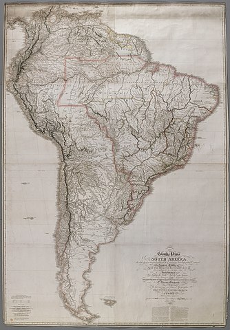
English: Colombia Prima OR SOUTH AMERICA, In which it has been attempted to delineate the Extent of our Knowledge of that Continent. : Extracted Chiefly FROM THE ORIGINAL MANUSCRIPT MAPS OF His Excellency the late Chevalier Pinto; Likewise from those of João Joaquim da Rocha, João da Costa Ferreira; El Padre Francisco Manuel Sobreviela &c. AND FROM MOST AUTHENTIC EDITED ACCOUNTS OF THOSE COUNTRIES . / Digested & Constructed BY LOUIS STANISLAS DARCY DE LA ROCHETTE. |
||||||||||||||||||||||
| Description |
English: Published on eight sheets. Includes 1777 demarcation line of the Treaty of San Ildefonso, settling territorial disputes between Spain and Portugal. Includes a key to the colours on the map: orange for Spanish dominions, red for Portuguese, yellow for Dutch and blue for French. Includes an advertisement by W. Faden, referencing the sources of the map. Includes an engraving note: "Cooper feript. et sculpt." Includes cities, towns, missions, parishes, rivers, swamps and mountains. Includes notes regarding indigenous population. Relief shown by hachuring and with soundings. |
||||||||||||||||||||||
| Date | |||||||||||||||||||||||
| Source |
Part of King George III's Topographical Collection. Donated to the nation by George IV. Please do not overwrite this file. Any cropped or modified version should be uploaded with a new name and linked in the "
|
||||||||||||||||||||||
| Creator |
Cartographer:
|
||||||||||||||||||||||
| Contributor |
Engraver:
|
||||||||||||||||||||||
| Permission (Reusing this file) |
|
||||||||||||||||||||||
| Geotemporal data | |||||||||||||||||||||||
| Map location | South America | ||||||||||||||||||||||
| Scale | 1:3,200,000 | ||||||||||||||||||||||
| OpenStreetMap zoom level | 3 | ||||||||||||||||||||||
| Bounding box |
|
||||||||||||||||||||||
| Georeferencing | If inappropriate please set warp_status = skip to hide. | ||||||||||||||||||||||
| Bibliographic data | |||||||||||||||||||||||
| Language | English | ||||||||||||||||||||||
| Place of publication | London : Published by Wiliam Faden, Geographer to His Majesty and to His Royal Highness the Prince of Wales | ||||||||||||||||||||||
| Publisher |
|
||||||||||||||||||||||
| Archival data | |||||||||||||||||||||||
| Collection | |||||||||||||||||||||||
| Accession number |
British Library Maps K.Top.124.14.2 TAB.END |
||||||||||||||||||||||
| Dimensions | height: 239 cm (94 in); width: 164 cm (64.5 in) | ||||||||||||||||||||||
| Metadata note | Initial version of this page based on information from the BL catalogue entry, updated 2017-12-08. Used with permission. Accessed 2018-09-18. | ||||||||||||||||||||||


.jpg&flash=no)
File history
Click on a date/time to view the file as it appeared at that time.
| Date/Time | Thumbnail | Dimensions | User | Comment | |
|---|---|---|---|---|---|
| current | 07:14, 22 September 2018 | | 8,553 × 12,297 (21.35 MB) | JhealdBot (talk | contribs) | JhealdBot(6): test upload |
You cannot overwrite this file.
File usage on Commons
The following page uses this file:
.jpg)
.jpg&oldid=865100460)