File:Coffs Harbour Shire Map 1965.png
Jump to navigation
Jump to search

Size of this preview: 447 × 599 pixels. Other resolutions: 179 × 240 pixels | 358 × 480 pixels | 862 × 1,156 pixels.
Original file (862 × 1,156 pixels, file size: 1.97 MB, MIME type: image/png)
Captions
Captions
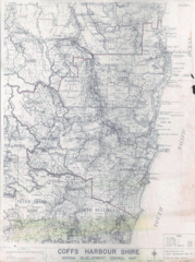
Map of Coffs Harbour Shire as of 1965.
Summary[edit]
| Description |
English: Publisher: State Planning Authority, NSW
Source: Coffs recollect https://coffs.recollect.net.au/nodes/view/68013 Copyright: Creative Commons Attribution 4.0 International Licence Description: This comprehensive map shows towns, rivers, forests, land holdings and parish names. The Coffs Harbour Shire local government area has been outlined in red ink. Publish Date: 1 March 1965 Courtesy of the City of Coffs Harbour (This is not supposed to be a second atempt to publish Coffs Harbour Shire Interim Development Control Map (1965), as that didn't have correct copyright information) |
| Date | |
| Source | https://coffs.recollect.net.au/nodes/view/68013 |
| Author |
Licensing[edit]
This file is licensed under the Creative Commons Attribution 4.0 International license.
- You are free:
- to share – to copy, distribute and transmit the work
- to remix – to adapt the work
- Under the following conditions:
- attribution – You must give appropriate credit, provide a link to the license, and indicate if changes were made. You may do so in any reasonable manner, but not in any way that suggests the licensor endorses you or your use.
Unknown author
File history
Click on a date/time to view the file as it appeared at that time.
| Date/Time | Thumbnail | Dimensions | User | Comment | |
|---|---|---|---|---|---|
| current | 01:52, 9 January 2024 | | 862 × 1,156 (1.97 MB) | Aidenmrmen (talk | contribs) | Uploaded a work by from https://coffs.recollect.net.au/nodes/view/68013 with UploadWizard |
You cannot overwrite this file.
File usage on Commons
There are no pages that use this file.
File usage on other wikis
The following other wikis use this file:
- Usage on en.wikipedia.org