File:Clouds surround the Galapagos Islands (MODIS 2020-09-21).jpg

Original file (3,388 × 2,807 pixels, file size: 1.31 MB, MIME type: image/jpeg)
Captions
Captions
Summary[edit]
.jpg&action=edit§ion=1)
| Description |
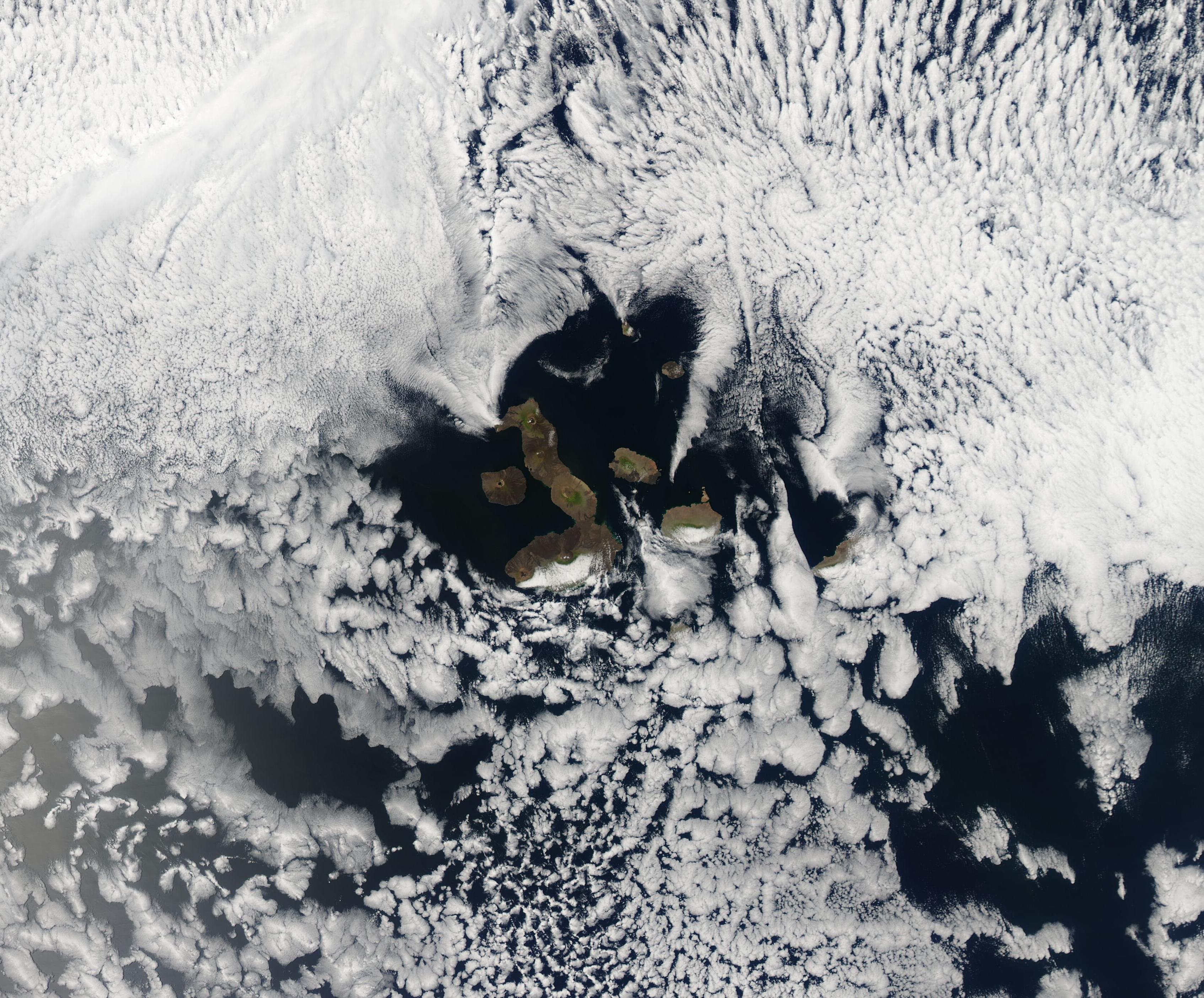
English: Often called the “Enchanted Islands”, the 19 volcanic islands that make up Ecuador’s Galapagos Islands sit about 1,000 km (621 mi) from the South American Continent and at the confluence of three ocean currents. The extreme isolation of the islands helped create unique species, many of which are found nowhere else on Earth, including the wide variety of finch that inspired Charles Darwin’s theory of evolution by natural selection.
The islands are often cloud-shrouded, especially in the dry season (garúa) which typically runs from June to November. This is when the trade winds blow more strongly and the Humboldt and Cromwell Undercurrent are the predominant currents. These cooler currents are accompanied by cooler air, which frequently results in the formation of an inversion layer – a layer of warmer air that traps cooler air underneath. The moisture that evaporates from the ocean is trapped within this inversion layer (300 to 600 meters (984-1968 feet) above sea level, creating low cloud. The higher mountain elevations sit within the cloud layer and receive rain, often in the form of mist (garúa means mist), while the lower elevations remain dry. On September 17, 2020, the Moderate Resolution Imaging Spectroradiometer (MODIS) on board NASA’s Terra satellite acquired a true-color image of clouds around the Galapagos Islands. While most of the islands remain in sunny skies, the eastern slopes of Isla Isabella (west) and Isla Santa Cruz (east) lie under the mist-filled clouds. Isla San Cristobal, in the southeast, is completely covered in cloud. |
||
| Date | Taken on 17 September 2020 | ||
| Source |
Clouds surround the Galapagos Islands (direct link)
|
||
| Author | MODIS Land Rapid Response Team, NASA GSFC |
| This media is a product of the Terra mission Credit and attribution belongs to the mission team, if not already specified in the "author" row |
Licensing[edit]
.jpg&action=edit§ion=2)
| This file is in the public domain in the United States because it was solely created by NASA. NASA copyright policy states that "NASA material is not protected by copyright unless noted". (See Template:PD-USGov, NASA copyright policy page or JPL Image Use Policy.) | ||
 |
Warnings:
|
File history
Click on a date/time to view the file as it appeared at that time.
| Date/Time | Thumbnail | Dimensions | User | Comment | |
|---|---|---|---|---|---|
| current | 02:37, 17 February 2024 | | 3,388 × 2,807 (1.31 MB) | OptimusPrimeBot (talk | contribs) | #Spacemedia - Upload of http://modis.gsfc.nasa.gov/gallery/images/image09212020_250m.jpg via Commons:Spacemedia |
You cannot overwrite this file.
File usage on Commons
There are no pages that use this file.
.jpg&oldid=852711422)