File:Cleveland Rapid map.svg
Jump to navigation
Jump to search

Size of this PNG preview of this SVG file: 800 × 453 pixels. Other resolutions: 320 × 181 pixels | 640 × 362 pixels | 1,024 × 580 pixels | 1,280 × 724 pixels | 2,560 × 1,449 pixels | 864 × 489 pixels.
Original file (SVG file, nominally 864 × 489 pixels, file size: 441 KB)
Captions
Captions
Add a one-line explanation of what this file represents
| This work has been released into the public domain by its author, SPUI. This applies worldwide. In some countries this may not be legally possible; if so: |
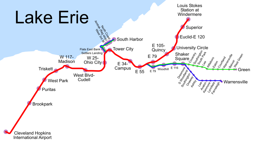
Map of Cleveland Rapid Transit, traced on USGS topos. The Blue and Green lines are light rail, and the Red Line is a metro.
File history
Click on a date/time to view the file as it appeared at that time.
| Date/Time | Thumbnail | Dimensions | User | Comment | |
|---|---|---|---|---|---|
| current | 18:54, 19 August 2007 | | 864 × 489 (441 KB) | FSHL (talk | contribs) | |
| 10:57, 27 November 2005 |  | 86 × 49 (441 KB) | SPUI~commonswiki (talk | contribs) | don't know where I got the info about 34th being Blue/Green only, but it seems to be wrong | |
| 21:05, 26 November 2005 |  | 86 × 49 (477 KB) | SPUI~commonswiki (talk | contribs) | {{spuimap}} Map of Cleveland Rapid Transit, traced on USGS topos. Category:Cleveland, Ohio Category:railroad maps |
You cannot overwrite this file.
File usage on Commons
The following 2 pages use this file:
File usage on other wikis
The following other wikis use this file:
- Usage on de.wikipedia.org
- Usage on fr.wikipedia.org
- Usage on it.wikipedia.org
- Usage on www.wikidata.org