File:Clegyr Boia ancient settlement - geograph.org.uk - 738968.jpg
Jump to navigation
Jump to search
No higher resolution available.
Clegyr_Boia_ancient_settlement_-_geograph.org.uk_-_738968.jpg (640 × 480 pixels, file size: 119 KB, MIME type: image/jpeg)
Captions
Captions
Add a one-line explanation of what this file represents
Summary[edit]
| Description |
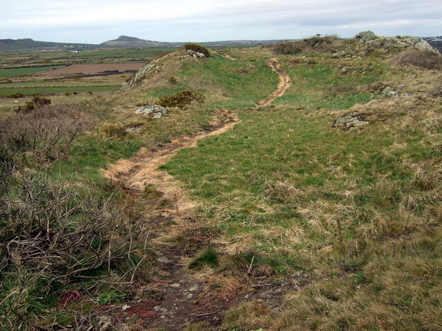
English: Clegyr Boia ancient settlement An oblong outcrop with rocky protrusions at both ends, the central area being dipped and clearly an ideal dwelling place, with a 360% view of the surrounding territory. Excavation has revealed signs of neolithic settlement (pottery, axes and hut circles) from 4000 BC: an idea of how it might have been can be seen here http://www.gtj.org.uk/item.php?lang=en&id=18546&t=1.
Habitation continued into the iron age when it is likely that earth ramparts were constructed to defend the rectangular enclosure. |
| Date | |
| Source | From geograph.org.uk |
| Author | ceridwen |
| Attribution (required by the license) | ceridwen / Clegyr Boia ancient settlement / |
| Camera location | | View this and other nearby images on: OpenStreetMap |
|---|
_heading:45.00&language=en)
| Object location | | View this and other nearby images on: OpenStreetMap |
|---|
_heading:45.00&language=en)
Licensing[edit]

|
This image was taken from the Geograph project collection. See this photograph's page on the Geograph website for the photographer's contact details. The copyright on this image is owned by ceridwen and is licensed for reuse under the Creative Commons Attribution-ShareAlike 2.0 license.
|
This file is licensed under the Creative Commons Attribution-Share Alike 2.0 Generic license.
Attribution: ceridwen
- You are free:
- to share – to copy, distribute and transmit the work
- to remix – to adapt the work
- Under the following conditions:
- attribution – You must give appropriate credit, provide a link to the license, and indicate if changes were made. You may do so in any reasonable manner, but not in any way that suggests the licensor endorses you or your use.
- share alike – If you remix, transform, or build upon the material, you must distribute your contributions under the same or compatible license as the original.
- Remove redundant categories and try to put this image in the most specific category/categories
- Remove this template
- The location categories are based on information from this geonames tool and this OpenStreetMap tool combined with a database. You can also have a look at this tool from mysociety.
- The topic category from Geograph was Hill fort (find similar images fort at Geograph)
File history
Click on a date/time to view the file as it appeared at that time.
| Date/Time | Thumbnail | Dimensions | User | Comment | |
|---|---|---|---|---|---|
| current | 07:34, 19 February 2011 | | 640 × 480 (119 KB) | GeographBot (talk | contribs) | == {{int:filedesc}} == {{Information |description={{en|1=Clegyr Boia ancient settlement An oblong outcrop with rocky protrusions at both ends, the central area being dipped and clearly an ideal dwelling place, with a 360% view of the surrounding territory |
You cannot overwrite this file.
File usage on Commons
There are no pages that use this file.