File:Chumi-Gyatse-Falls-LSIB.jpg
Jump to navigation
Jump to search

Size of this preview: 800 × 425 pixels. Other resolutions: 320 × 170 pixels | 640 × 340 pixels | 1,238 × 658 pixels.
Original file (1,238 × 658 pixels, file size: 109 KB, MIME type: image/jpeg)
Captions
Captions
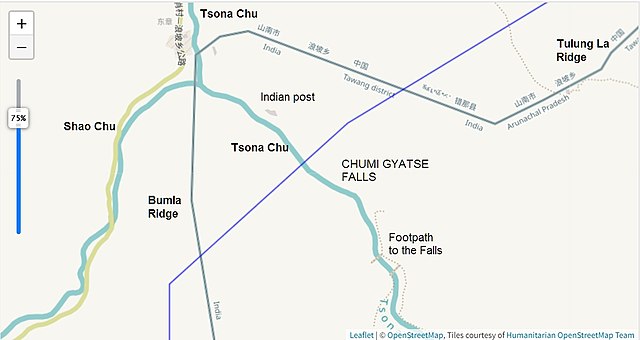
Line of Actual Control near the [[:w:Chumi Gyatse Falls]] in the [[:w:Tawang district]], India
Summary[edit]
| Description |
English: The map depicts the China-India w:Line of Actual Control near the w:Chumi Gyatse Falls, as marked by the US Office of The Geographer in 2012 (in blue) and the OpenStreetMap in December 2022 (in green). Annotations by User:Kautilya3 |
| Date | |
| Source | https://earthworks.stanford.edu/catalog/stanford-jd523yw3613 |
| Author | US Office of Geographer, Stanford University, Contributors to the OpenStreetmap |
Licensing[edit]
This file is licensed under the Creative Commons Attribution-Share Alike 2.5 Generic license.
- You are free:
- to share – to copy, distribute and transmit the work
- to remix – to adapt the work
- Under the following conditions:
- attribution – You must give appropriate credit, provide a link to the license, and indicate if changes were made. You may do so in any reasonable manner, but not in any way that suggests the licensor endorses you or your use.
- share alike – If you remix, transform, or build upon the material, you must distribute your contributions under the same or compatible license as the original.
File history
Click on a date/time to view the file as it appeared at that time.
| Date/Time | Thumbnail | Dimensions | User | Comment | |
|---|---|---|---|---|---|
| current | 19:13, 31 December 2022 | | 1,238 × 658 (109 KB) | Kautilya3 (talk | contribs) | Uploaded a work by US Office of Geographer, Stanford University, Contributors to the OpenStreetmap from https://earthworks.stanford.edu/catalog/stanford-jd523yw3613 with UploadWizard |
You cannot overwrite this file.
File usage on Commons
There are no pages that use this file.
File usage on other wikis
The following other wikis use this file:
- Usage on en.wikipedia.org