File:Christmas Island Australia 76-fr.png
Jump to navigation
Jump to search

Size of this preview: 663 × 600 pixels. Other resolutions: 265 × 240 pixels | 531 × 480 pixels | 849 × 768 pixels | 1,132 × 1,024 pixels | 1,462 × 1,322 pixels.
Original file (1,462 × 1,322 pixels, file size: 365 KB, MIME type: image/png)
Captions
Captions
Add a one-line explanation of what this file represents
Summary[edit]
| Camera location | | View this and other nearby images on: OpenStreetMap |
|---|
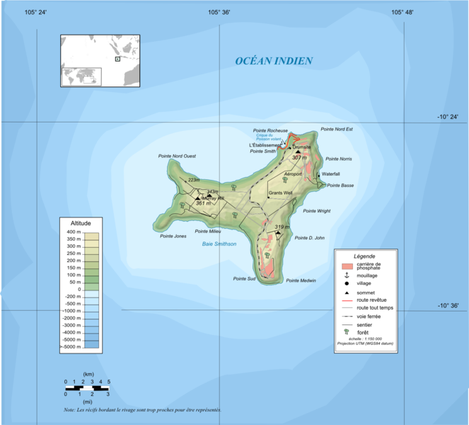
| Description | Topographic map in French of Christmas Island , Australie |
| Date | |
| Source |
Own work Topography : NASA Shuttle Radar Topography Mission (SRTM3 v.2) data (public domain) edited with 3DEM and dlgv32 Pro and vectorized with Inkscape ; UTM projection ; WGS84 datum ; Bathymetry : USGov public domain data provided by Demis (see the approval e-mail and the Demis forum) ; References used for the additional data : *Perry-Castaneda (PCL) |
| Author | Ewan ar Born |
| Other versions |
[]
|


Français : * Sujet : Carte topographique en français de Christmas Island, Australie ;
- Sources : Création personnelle ;
- Topographie : Données de la NASA Shuttle Radar Topography Mission (SRTM3 v.2) (domaine public) éditées avec 3DEM et dlgv32 Pro et vectorisées avec Inkscape ; projection UTM ; WGS84 datum ;
- Bathymétrie : Données du gouvernement des ÉUA dans le domaine public fournies par Demis (voir le courriel d'approbation et le forum de Demis) ;
- Références utilisées pour les données complémentaires :
- Bathymétrie : 1:4 000 000 (précision : environ 1 000 m) ;
- Auteur :(fr:Ewan ar Born) ;
- Date : 11 Août 2008
Licensing[edit]
I, the copyright holder of this work, hereby publish it under the following licenses:

|
Permission is granted to copy, distribute and/or modify this document under the terms of the GNU Free Documentation License, Version 1.2 or any later version published by the Free Software Foundation; with no Invariant Sections, no Front-Cover Texts, and no Back-Cover Texts. A copy of the license is included in the section entitled GNU Free Documentation License. |
This file is licensed under the Creative Commons Attribution-Share Alike 3.0 Unported, 2.5 Generic, 2.0 Generic and 1.0 Generic license.
- You are free:
- to share – to copy, distribute and transmit the work
- to remix – to adapt the work
- Under the following conditions:
- attribution – You must give appropriate credit, provide a link to the license, and indicate if changes were made. You may do so in any reasonable manner, but not in any way that suggests the licensor endorses you or your use.
- share alike – If you remix, transform, or build upon the material, you must distribute your contributions under the same or compatible license as the original.
You may select the license of your choice.
File history
Click on a date/time to view the file as it appeared at that time.
| Date/Time | Thumbnail | Dimensions | User | Comment | |
|---|---|---|---|---|---|
| current | 13:52, 11 August 2008 | | 1,462 × 1,322 (365 KB) | Ewan ar Born (talk | contribs) | == Description == == Summary == {{Location|10|25|00|S|105|43|00|E|scale:150000}} <br/> {{Information |Description=Topographic map in French of Christmas Island , Australie |Source=Own work ;<br/>Topography : [htt |
You cannot overwrite this file.
File usage on Commons
There are no pages that use this file.
File usage on other wikis
The following other wikis use this file:
- Usage on bn.wikipedia.org
- Usage on en.wikipedia.org