File:Christiana-Riot-Map-1851.png
Jump to navigation
Jump to search

Size of this preview: 620 × 599 pixels. Other resolutions: 248 × 240 pixels | 496 × 480 pixels | 794 × 768 pixels | 1,059 × 1,024 pixels | 1,688 × 1,632 pixels.
Original file (1,688 × 1,632 pixels, file size: 4.25 MB, MIME type: image/png)
Captions
Captions
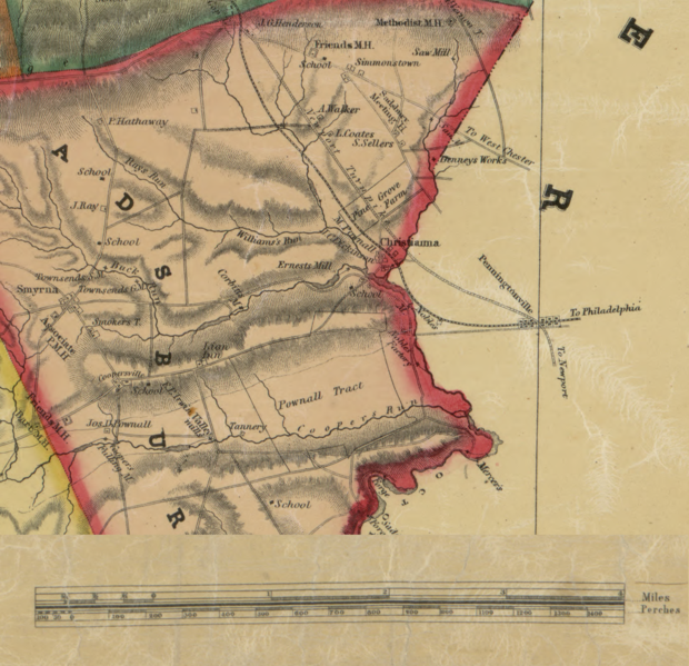
Map of the area of Christiana, Pennsylvania at the time of the 1851 Christiana Riot
Summary[edit]
| Description |
English: A portion of an 1851 map showing various places of importance for the Christiana Riot. Notably Penningtonville station in Chester county, the community of Christiana in Sadsbury Township (Lancaster county). The Parker house where the attack took place is located in the Pownall Tract. |
| Date | |
| Source | A map derived from the Map of Lancaster County, Pennsylvania, published 1851 and held by the Library of Congress https://www.loc.gov/item/2012592191/ The derivation is a small portion of the map depicting Christiana, PA and with the map scale moved to be on this portion. |
| Author | Original author is not listed. I create the derivation |
Licensing[edit]
This work is in the public domain in the United States because it was published (or registered with the U.S. Copyright Office) before January 1, 1929.
Public domain works must be out of copyright in both the United States and in the source country of the work in order to be hosted on the Commons. If the work is not a U.S. work, the file must have an additional copyright tag indicating the copyright status in the source country.
Note: This tag should not be used for sound recordings. |
File history
Click on a date/time to view the file as it appeared at that time.
| Date/Time | Thumbnail | Dimensions | User | Comment | |
|---|---|---|---|---|---|
| current | 07:39, 2 February 2019 | | 1,688 × 1,632 (4.25 MB) | Erp (talk | contribs) | User created page with UploadWizard |
You cannot overwrite this file.
File usage on Commons
There are no pages that use this file.
File usage on other wikis
The following other wikis use this file:
- Usage on ceb.wikipedia.org
- Usage on en.wikipedia.org