File:Chinese traditional equatorial coordinate system.png
Jump to navigation
Jump to search

Size of this preview: 629 × 599 pixels. Other resolutions: 252 × 240 pixels | 504 × 480 pixels | 799 × 761 pixels.
Original file (799 × 761 pixels, file size: 40 KB, MIME type: image/png)
Captions
Captions
Add a one-line explanation of what this file represents
Summary[edit]
| Description |
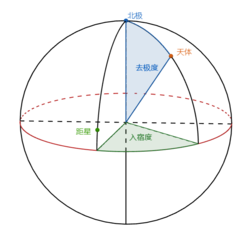
中文(简体):中国传统天球赤道坐标系。红色为天赤道圈。绿色点为距星,共二十八颗作为坐标,即二十八宿。蓝色点为天北极。计算橙色天体的位置时,用入宿度(绿色扇形的角度)表示赤经,用去极度(蓝色扇形的角度)表示赤纬。 |
| Date | |
| Source | Own work |
| Author | 三猎 |
Licensing[edit]
I, the copyright holder of this work, hereby publish it under the following license:
This file is licensed under the Creative Commons Attribution-Share Alike 4.0 International license.
- You are free:
- to share – to copy, distribute and transmit the work
- to remix – to adapt the work
- Under the following conditions:
- attribution – You must give appropriate credit, provide a link to the license, and indicate if changes were made. You may do so in any reasonable manner, but not in any way that suggests the licensor endorses you or your use.
- share alike – If you remix, transform, or build upon the material, you must distribute your contributions under the same or compatible license as the original.
File history
Click on a date/time to view the file as it appeared at that time.
| Date/Time | Thumbnail | Dimensions | User | Comment | |
|---|---|---|---|---|---|
| current | 05:01, 30 June 2019 | | 799 × 761 (40 KB) | 三猎 (talk | contribs) | 裁剪。 |
| 04:58, 30 June 2019 |  | 1,836 × 814 (47 KB) | 三猎 (talk | contribs) | User created page with UploadWizard |
You cannot overwrite this file.
File usage on Commons
There are no pages that use this file.