File:Chesterdeaneries1835.png
Jump to navigation
Jump to search

Size of this preview: 682 × 600 pixels. Other resolutions: 273 × 240 pixels | 546 × 480 pixels | 936 × 823 pixels.
Original file (936 × 823 pixels, file size: 269 KB, MIME type: image/png)
Captions
Captions
Add a one-line explanation of what this file represents
Summary[edit]
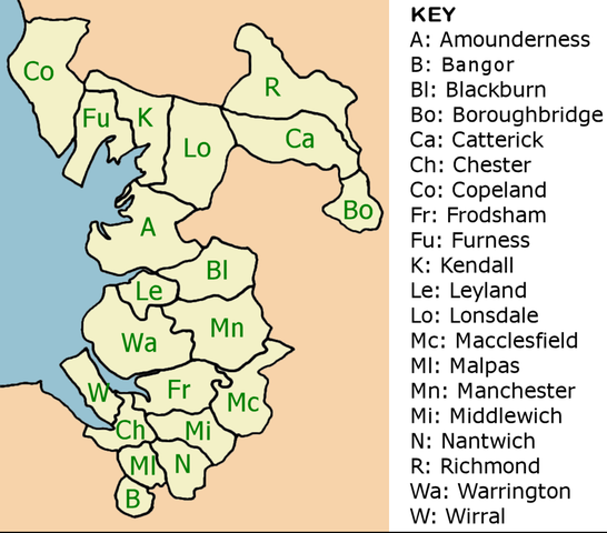
| Description | Map showing the deaneries that made up the Diocese of Chester diocese (UK) in 1835, just prior to a series of boundary changes that would mean the Diocese eventually was restricted to roughly the boundaries of Cheshire as it existed after 1900. |
| Date | |
| Source | Own work |
| Author | David D Stretch User:Ddstretch |

|
File:Chesterdeaneries1835.svg is a vector version of this file. It should be used in place of this PNG file.
File:Chesterdeaneries1835.png → File:Chesterdeaneries1835.svg
For more information, see Help:SVG. |
 |
Licensing[edit]
| I, the copyright holder of this work, release this work into the public domain. This applies worldwide. In some countries this may not be legally possible; if so: I grant anyone the right to use this work for any purpose, without any conditions, unless such conditions are required by law. |
File history
Click on a date/time to view the file as it appeared at that time.
| Date/Time | Thumbnail | Dimensions | User | Comment | |
|---|---|---|---|---|---|
| current | 13:11, 15 February 2008 | | 936 × 823 (269 KB) | Ddstretch (talk | contribs) | {{Information |Description=Map showing the deaneries that made up the Diocese of Chester diocese (UK) in 1835, just prior to a series of boundary changes that would mean the Diocese eventually was restricted to roughly the boundaries of Cheshire as it exi |
| 22:28, 13 February 2008 |  | 936 × 823 (270 KB) | Ddstretch (talk | contribs) | {{Information |Description=Map showing the deaneries that made up the Diocese of Chester diocese (UK) in 1835, just prior to a series of boundary changes that would mean the Diovcese eventually was restricted to roughly the boundaries of Cheshire as it ex |
You cannot overwrite this file.
File usage on Commons
There are no pages that use this file.