File:Chesapeake Bay impact crater.jpg
Jump to navigation
Jump to search
No higher resolution available.
Chesapeake_Bay_impact_crater.jpg (597 × 589 pixels, file size: 163 KB, MIME type: image/jpeg)
Captions
Captions
Add a one-line explanation of what this file represents
Summary[edit]
| Description |
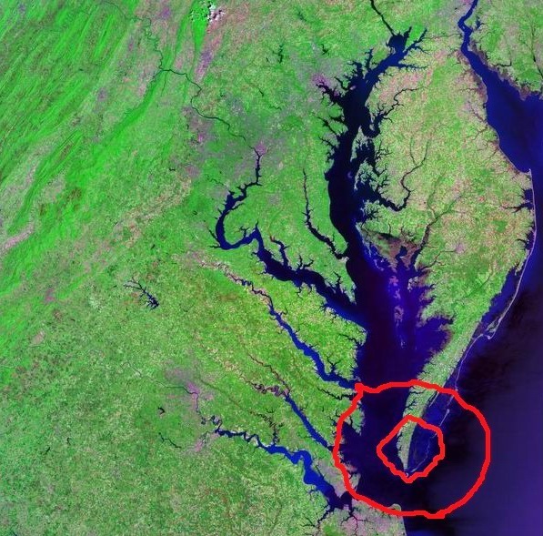
English: Satellite (Landsat) picture of Chesapeake Bay (center) and Delaware Bay (upper right) - and Atlantic coast of the central-eastern United States + overlay of two impact crater rings (Namesnik) |
| Date | circa 2000 |
| Source | Landsat photo, from circa 2000. Generated via [1] from NASA data + overlay of two impact crater rings (Namesnik) |
| Author | Landsat/NASA |
| Other versions |

Licensing[edit]
| This file is in the public domain in the United States because it was solely created by NASA. NASA copyright policy states that "NASA material is not protected by copyright unless noted". (See Template:PD-USGov, NASA copyright policy page or JPL Image Use Policy.) | ||
 |
Warnings:
|
File history
Click on a date/time to view the file as it appeared at that time.
| Date/Time | Thumbnail | Dimensions | User | Comment | |
|---|---|---|---|---|---|
| current | 14:15, 10 December 2022 | | 597 × 589 (163 KB) | Namesnik (talk | contribs) | Uploaded own work with UploadWizard |
You cannot overwrite this file.
File usage on Commons
The following page uses this file:
File usage on other wikis
The following other wikis use this file:
- Usage on ru.wikipedia.org