File:Chambersburg - Hancock - Hagerstown.png
Jump to navigation
Jump to search

Size of this preview: 800 × 320 pixels. Other resolutions: 320 × 128 pixels | 640 × 256 pixels | 1,244 × 497 pixels.
Original file (1,244 × 497 pixels, file size: 974 KB, MIME type: image/png)
Captions
Captions
Add a one-line explanation of what this file represents
Summary[edit]
| Description |
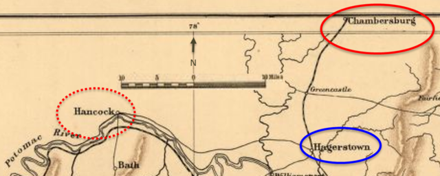
English: The map shows important points during the beginning of Confederate General John McCausland’s raid on Chambersburg, Pennsylvania, and the immediate period after. McCausland was pursued by Union General William W. Averell. These U.S. Civil War events took place during late July and early August 1864. |
| Date | |
| Source | This is a portion of a 1912 map created by Sifton, Praed & Co. that has been modified by TwoScarsUp in 2017. The entire map can be found in the Library of Congress map, and shows mostly Virginia and Maryland with small portions of Pennsylvania and West Virginia. |
| Author | Sifton, Praed & Company, Ltd. modified by TwoScarsUp |
Licensing[edit]
This work is in the public domain in the United States because it was published (or registered with the U.S. Copyright Office) before January 1, 1929.
Public domain works must be out of copyright in both the United States and in the source country of the work in order to be hosted on the Commons. If the work is not a U.S. work, the file must have an additional copyright tag indicating the copyright status in the source country.
Note: This tag should not be used for sound recordings. |
File history
Click on a date/time to view the file as it appeared at that time.
| Date/Time | Thumbnail | Dimensions | User | Comment | |
|---|---|---|---|---|---|
| current | 17:05, 15 May 2017 | 1,244 × 497 (974 KB) | TwoScarsUp (talk | contribs) | User created page with UploadWizard |
You cannot overwrite this file.
File usage on Commons
The following page uses this file:
File usage on other wikis
The following other wikis use this file:
- Usage on en.wikipedia.org
- Usage on fr.wikipedia.org