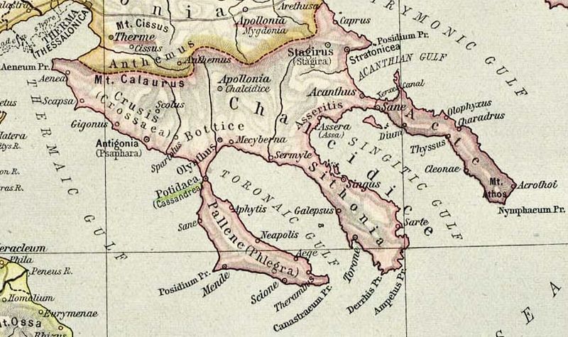
File:Chalcidice.jpg

Original file (854 × 507 pixels, file size: 209 KB, MIME type: image/jpeg)
Captions
Captions
Summary[edit]
| DescriptionChalcidice.jpg |
English: Map of Chalcidice, cropped from old public domain map of Greece, from the Perry-Castañeda Library Map Collection, Historical Atlas by William R. Shepherd. Note that the location shown for Stagirus (Stagira) is the site of the modern village. Ancient Stagira is located on the coast north of that at the position labeled "Caprus", the name of the island off the coast of Stagira. north, south |
||
| Date | |||
| Source |
|
||
| Author | William Robert Shepherd |
Licensing[edit]
| Public domainPublic domainfalsefalse |
|
This work is in the public domain in its country of origin and other countries and areas where the copyright term is the author's life plus 75 years or fewer.
| |
| This file has been identified as being free of known restrictions under copyright law, including all related and neighboring rights. | |
https://creativecommons.org/publicdomain/mark/1.0/PDMCreative Commons Public Domain Mark 1.0falsefalse
File history
Click on a date/time to view the file as it appeared at that time.
| Date/Time | Thumbnail | Dimensions | User | Comment | |
|---|---|---|---|---|---|
| current | 19:49, 19 April 2013 |  | 854 × 507 (209 KB) | Jbarta (talk | contribs) | lighten |
| 08:27, 12 December 2006 |  | 854 × 507 (135 KB) | Roke~commonswiki (talk | contribs) | Map of Chalcidice, cropped from old public domain map of Greece, from the Perry-Castañeda Library Map Collection, Historical Atlas by William R. Shepherd [http://www.lib.utexas.edu/maps/historical/shepherd/greece_ancient_n_ref_1926.jpg north], [http://ww |
You cannot overwrite this file.
File usage on Commons
The following 2 pages use this file:
File usage on other wikis
The following other wikis use this file:
- Usage on bg.wikipedia.org
- Usage on ca.wikipedia.org
- Usage on da.wikipedia.org
- Usage on de.wikipedia.org
- Usage on el.wikipedia.org
- Usage on en.wikipedia.org
- Usage on eo.wikipedia.org
- Usage on es.wikipedia.org
View more global usage of this file.