File:Châteaux de la Loire - Karte.jpg
Jump to navigation
Jump to search
Size of this preview: 800 × 305 pixels. Other resolutions: 320 × 122 pixels | 640 × 244 pixels | 1,024 × 390 pixels | 1,280 × 487 pixels | 4,057 × 1,545 pixels.
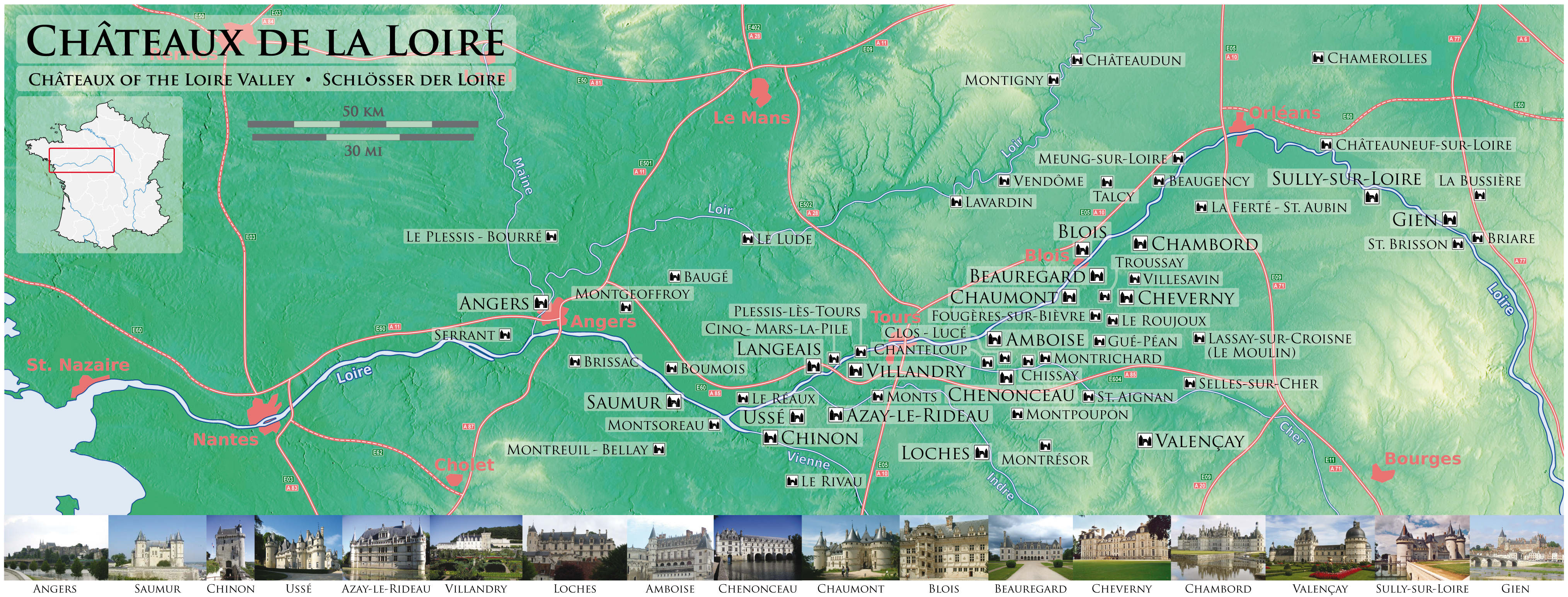
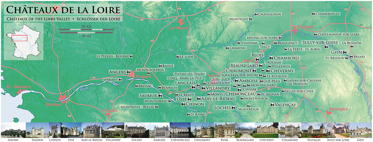
Original file (4,057 × 1,545 pixels, file size: 5.23 MB, MIME type: image/jpeg)
Captions
Captions
Add a one-line explanation of what this file represents
| Description |
Deutsch: Schlösser der Loire
English: Châteaux of the Loire Valley
Français : Châteaux de la Loire
Македонски: Замоците на Лоара
Slovenčina: Zámky na Loire
|
|
| Date | ||
| Source |
Own work Using maps-for-free.com for the topographic background, this map for the orientation map of France, and this sign as draft for the motorway numberings. The sources of the images of the Châteaux are: Amboise, Angers, Azay-le-Rideau, Beauregard, Blois, Chambord, Chaumont, Chennonceau, Cheverny, Chinon, Gien, Loches, Saumur, Sully-sur-Loire, Ussé, Valençay, Villandry. |
|
| Author | Maximilian Dörrbecker (Chumwa) | |
| Permission (Reusing this file) |
I, the copyright holder of this work, hereby publish it under the following license: This file is licensed under the Creative Commons Attribution-Share Alike 2.5 Generic license.
Sie dürfen das Bild zu den folgenden Bedingungen nutzen:
|
File history
Click on a date/time to view the file as it appeared at that time.
| Date/Time | Thumbnail | Dimensions | User | Comment | |
|---|---|---|---|---|---|
| current | 21:02, 29 May 2009 | 4,057 × 1,545 (5.23 MB) | Chumwa (talk | contribs) | Korrektur: Plessis-dès-Tours -> Plessis-lès-Tours (vielen Dank an Sir Gawain für den fehlerhinweis!) | |
| 06:39, 24 March 2008 | 2,817 × 1,072 (1.32 MB) | Chumwa (talk | contribs) | Europastraßen-Nummern ergänzt und Maßstabsleiste abgedimmt. | ||
| 21:42, 23 March 2008 | 2,817 × 1,072 (1.32 MB) | Chumwa (talk | contribs) | Diverse Anmerkungen von mario eingearbeitet (Details s. [http://de.wikipedia.org/w/index.php?title=Wikipedia:Kartenwerkstatt&oldid=44041288 hier]) und vier weitere Schlösser aufgenommen. | ||
| 07:14, 23 March 2008 | 2,817 × 1,072 (923 KB) | Chumwa (talk | contribs) | {{Information |Description= *{{ de }} Schlösser der Loire *{{ en }} Châteaux of the Loire Valley *{{ fr }} Châteaux de la Loire {{Template:Kartenwerkstatt}} |Source=Self made. Using [http://www.maps-for-free.com/ maps-for-free.com] for the topographi |
You cannot overwrite this file.
File usage on Commons
The following 4 pages use this file:
File usage on other wikis
The following other wikis use this file:
- Usage on ar.wikipedia.org
- Usage on br.wikipedia.org
- Usage on ca.wikipedia.org
- Usage on cs.wikipedia.org
- Usage on da.wikipedia.org
- Usage on de.wikipedia.org
- Usage on de.wikivoyage.org
- Usage on el.wikipedia.org
- Usage on en.wikipedia.org
- Usage on eo.wikipedia.org
- Usage on es.wikipedia.org
- Usage on eu.wikipedia.org
- Usage on fr.wikipedia.org
- Usage on he.wikipedia.org
- Usage on hy.wikipedia.org
- Usage on it.wikipedia.org
- Usage on ja.wikipedia.org
- Usage on ka.wikipedia.org
- Usage on ko.wikipedia.org
- Usage on lb.wikipedia.org
- Usage on lt.wikipedia.org
- Usage on mk.wikipedia.org
- Usage on nl.wikipedia.org
- Usage on no.wikipedia.org
- Usage on pcd.wikipedia.org
- Usage on pl.wikipedia.org
- Usage on pnb.wikipedia.org
- Usage on pt.wikipedia.org
- Usage on ro.wikipedia.org
- Usage on ru.wikipedia.org
- Usage on scn.wikipedia.org
- Usage on sk.wikipedia.org
- Usage on sl.wikipedia.org
- Usage on sv.wikipedia.org
- Usage on th.wikipedia.org
- Usage on uk.wikipedia.org
View more global usage of this file.