File:CentervilleBeachCrossCliff.jpg
Original file (3,072 × 2,304 pixels, file size: 3.15 MB, MIME type: image/jpeg)
Captions
Summary[edit]
DescriptionCentervilleBeachCrossCliff.jpg |
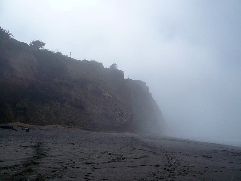
English: Centerville Beach Cross marks the location of the loss of the SS Northerner. In 1921, the Ferndale Parlor of the Native Sons of the Golden West placed a cross and marker on the hill overlooking Centerville Beach. The first marker was destroyed in the 1992 Cape Mendocino earthquakes. A new marker was placed and rededicated on February 11, 1995. The only approach is up an ATV trail on a nearly vertical cliff. California Historical Landmark Reference #173 |
|||
Date | ||||
Source | Own work | |||
Author | Ellin Beltz | |||
Permission (Reusing this file) |
|
This image was uploaded as part of Wiki Loves Monuments 2012.
Afrikaans ∙ Alemannisch ∙ azərbaycanca ∙ Bahasa Indonesia ∙ Bahasa Melayu ∙ Bikol Central ∙ bosanski ∙ brezhoneg ∙ català ∙ čeština ∙ Cymraeg ∙ dansk ∙ davvisámegiella ∙ Deutsch ∙ eesti ∙ English ∙ español ∙ Esperanto ∙ euskara ∙ français ∙ Frysk ∙ Gaeilge ∙ galego ∙ hrvatski ∙ Ido ∙ italiano ∙ latviešu ∙ Lëtzebuergesch ∙ Malagasy ∙ magyar ∙ Malti ∙ Nederlands ∙ norsk ∙ norsk nynorsk ∙ norsk bokmål ∙ polski ∙ português ∙ português do Brasil ∙ română ∙ shqip ∙ sicilianu ∙ slovenčina ∙ slovenščina ∙ suomi ∙ svenska ∙ Tagalog ∙ Türkçe ∙ Yorùbá ∙ Zazaki ∙ Ελληνικά ∙ беларуская ∙ беларуская (тарашкевіца) ∙ български ∙ кыргызча ∙ македонски ∙ русский ∙ српски / srpski ∙ українська ∙ ქართული ∙ հայերեն ∙ नेपाली ∙ हिन्दी ∙ বাংলা ∙ മലയാളം ∙ ไทย ∙ 한국어 ∙ +/− |
Camera location | 40° 34′ 11.25″ N, 124° 21′ 05.73″ W | View this and other nearby images on: OpenStreetMap | 40.569792; -124.351592 |
---|
File history
Click on a date/time to view the file as it appeared at that time.
Date/Time | Thumbnail | Dimensions | User | Comment | |
---|---|---|---|---|---|
current | 21:18, 24 September 2012 | 3,072 × 2,304 (3.15 MB) | Ellin Beltz (talk | contribs) | {{Information |Description ={{en|1=Centerville Beach Cross marks the location of the loss of the Northerner. In 1921, the Ferndale Parlor of the Native Sons of the Golden West placed a cross and marker on the hill overlooking Centerville Beach. The ... |
You cannot overwrite this file.
File usage on Commons
The following page uses this file:
File usage on other wikis
The following other wikis use this file:
- Usage on ca.wikipedia.org
- Usage on en.wikipedia.org
- Usage on www.wikidata.org
Metadata
This file contains additional information such as Exif metadata which may have been added by the digital camera, scanner, or software program used to create or digitize it. If the file has been modified from its original state, some details such as the timestamp may not fully reflect those of the original file. The timestamp is only as accurate as the clock in the camera, and it may be completely wrong.
Camera manufacturer | Panasonic |
---|---|
Camera model | DMC-FX12 |
Exposure time | 1/800 sec (0.00125) |
F-number | f/8 |
ISO speed rating | 100 |
Date and time of data generation | 12:35, 25 September 2012 |
Lens focal length | 5.8 mm |
Orientation | Normal |
Horizontal resolution | 72 dpi |
Vertical resolution | 72 dpi |
Software used | Adobe Photoshop Elements 6.0 Macintosh |
File change date and time | 13:49, 24 September 2012 |
Y and C positioning | Co-sited |
Exposure Program | Normal program |
Exif version | 2.21 |
Date and time of digitizing | 12:35, 25 September 2012 |
Meaning of each component |
|
Image compression mode | 4 |
APEX exposure bias | 0 |
Maximum land aperture | 3 APEX (f/2.83) |
Metering mode | Pattern |
Light source | Unknown |
Flash | Flash did not fire, compulsory flash suppression |
Supported Flashpix version | 1 |
Color space | sRGB |
Sensing method | One-chip color area sensor |
File source | Digital still camera |
Scene type | A directly photographed image |
Custom image processing | Normal process |
Exposure mode | Auto exposure |
White balance | Auto white balance |
Digital zoom ratio | 0 |
Focal length in 35 mm film | 35 mm |
Scene capture type | Standard |
Scene control | None |
Contrast | Normal |
Saturation | Normal |
Sharpness | Normal |
Supported Flashpix version | 1 |
Image width | 3,072 px |
Image height | 2,304 px |
Date metadata was last modified | 06:49, 24 September 2012 |
Structured data
Items portrayed in this file
depicts
24 September 2012
40°34'11.251"N, 124°21'5.731"W
image/jpeg
3f384d62c8caca660461ac5ca3d150650a0bc0c5
3,301,071 byte
2,304 pixel
3,072 pixel
- Self-published work
- PD-self
- Images from Wiki Loves Monuments 2012
- Images from Wiki Loves Monuments 2012 in the United States
- Images from Wiki Loves Monuments missing SDC depicts
- Images from Wiki Loves Monuments missing SDC location of creation
- Files with coordinates missing SDC location of creation
- WLM 2012 United States reviewed
- Photographs by Ellin Beltz
- Pages with maps