File:Centaurea cyanoides 10.JPG
Jump to navigation
Jump to search

Size of this preview: 800 × 600 pixels. Other resolutions: 320 × 240 pixels | 640 × 480 pixels | 1,024 × 768 pixels | 1,280 × 960 pixels | 2,560 × 1,920 pixels | 3,648 × 2,736 pixels.
Original file (3,648 × 2,736 pixels, file size: 2.11 MB, MIME type: image/jpeg)
Captions
Captions
Add a one-line explanation of what this file represents
Summary[edit]
| Description |
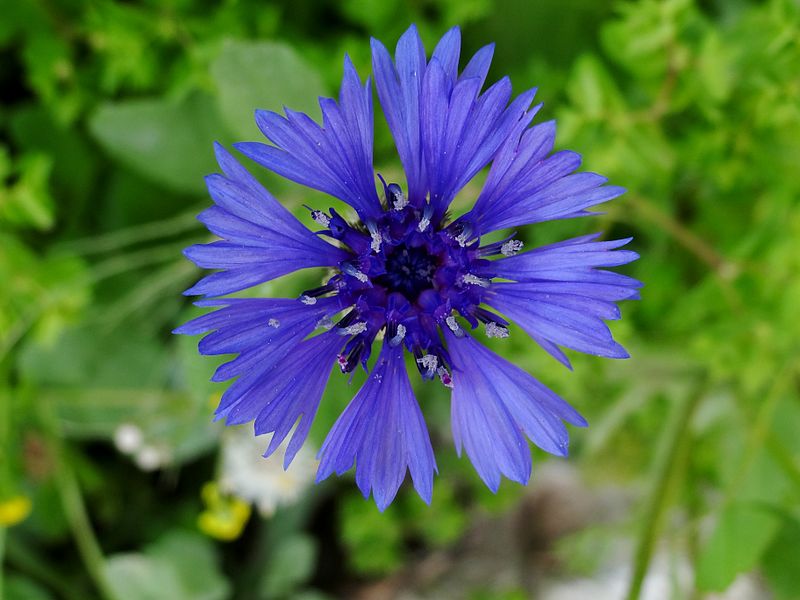
עברית: דַּרְדַּר כָּחֹל (המכונה Syrian Cornflower-thistle, Knapweed; שם מדעי: Centaurea cyanoides) הוא צמח חד-שנתי ממשפחת המורכבים. צבעי הפרחים מהסוג דַּרְדַּר משותפים לאבקנים ולעלי הכותרת. לזרעונים חסרה "ציצית" - המופיעה בצמחים אחרים ממשפחה זו. הציצית היא קבוצת שערות או מוצים ארוכים בראש הזרעונים התורמים להסעתם. בניגוד לכמה מינים אחרים בסוג דרדר, שחפי המעטפת שלהם קוצניים, הדרדר הכחול אינו קוצני. הדרדר הכחול הוא מין אנדמי לארץ ישראל, ירדן, סוריה, לבנון וקפריסין[1]. הוא גדל בבתה בשפלה המרכזית ובהר ופורח בין החודשים פברואר לאפריל. |
| Date | |
| Source | Own work |
| Author | Hanay |
| Permission (Reusing this file) |
This file is licensed under the Creative Commons Attribution-Share Alike 3.0 Unported license. Attribution: Hanay
|
| Camera location | | View this and other nearby images on: OpenStreetMap |
|---|
Licensing[edit]
|
File history
Click on a date/time to view the file as it appeared at that time.
| Date/Time | Thumbnail | Dimensions | User | Comment | |
|---|---|---|---|---|---|
| current | 19:16, 19 May 2012 | | 3,648 × 2,736 (2.11 MB) | Hanay (talk | contribs) |
You cannot overwrite this file.
File usage on Commons
The following 7 pages use this file:
File usage on other wikis
The following other wikis use this file:
- Usage on ceb.wikipedia.org
- Usage on de.wikipedia.org
- Usage on en.wikipedia.org
- Usage on he.wikipedia.org
- דו-פסיגיים
- מורכבים
- דרדר כחול
- פורטל:בוטניקה/פרחי ארץ ישראל לפי צבעים/פרחים כחולים
- משתמש:MathKnight/אוסף פרחים
- ויקיפדיה:תמונה מומלצת/המלצות קודמות/מרץ 2017
- ויקיפדיה:תמונה מומלצת/הוספה למומלצים/ארכיון 96
- תבנית:תמונה מומלצת 10 במרץ 2017
- ויקיפדיה:תמונה מומלצת/המלצות קודמות/יולי 2023
- תבנית:תמונה מומלצת 28 ביולי 2023
- Usage on he.wiktionary.org