File:Cedar Grove farmhouse and outbuilding.jpg
Jump to navigation
Jump to search

Size of this preview: 800 × 532 pixels. Other resolutions: 320 × 213 pixels | 640 × 426 pixels | 1,024 × 682 pixels | 1,280 × 852 pixels | 2,560 × 1,704 pixels | 5,553 × 3,696 pixels.
Original file (5,553 × 3,696 pixels, file size: 5.68 MB, MIME type: image/jpeg)
Captions
Captions
Add a one-line explanation of what this file represents
|
This is an image of a place or building that is listed on the National Register of Historic Places in the United States of America. Its reference number is 100001511. |
| Camera location | | View this and other nearby images on: OpenStreetMap |
|---|
| Description |
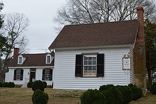
English: 1770s farmhouse and 1850s outbuilding at the Cedar Grove complex, located at 1083 Blanes Mill Lane southwest of South Boston in Halifax County, Virginia, United States. The complex is listed on the National Register of Historic Places. |
||
| Date | Taken on 17 February 2018 | ||
| Source | Own work | ||
| Author | Nyttend | ||
| Permission (Reusing this file) |
|
||
| Other versions | None |
File history
Click on a date/time to view the file as it appeared at that time.
| Date/Time | Thumbnail | Dimensions | User | Comment | |
|---|---|---|---|---|---|
| current | 13:10, 3 March 2018 | | 5,553 × 3,696 (5.68 MB) | Nyttend (talk | contribs) | Getting rid of a part of my car door |
| 13:08, 3 March 2018 |  | 6,016 × 4,000 (7.03 MB) | Nyttend (talk | contribs) | {{NRHP|100001511}} {{Location|36|36|37|N|78|59|31|W}} {{Information |Description={{en|1770s farmhouse and 1850s outbuilding at the {{w|Cedar Grove (Halifax County, Virginia)|Cedar Grove}} complex, located at 1083 Blanes Mill Lane southwest of {{w|South Boston, Virginia|South Boston}} in {{w|Halifax County, Virginia|Halifax County}}, {{w|Virginia}}, {{w|United States}}. The complex is listed on the {{w|National Register of Historic Places}}.}} |Source={{own}} |Date={{Taken on|2018-02-17}} |Author={{w|User:Nyttend|Nyttend}} |Permission={{PD-self}} |other_versions=N<nowiki></nowiki>one }} Category:Farmhouses in Virginia Category:National Register of Historic Places in Halifax County, Virginia Category:Wooden houses in Halifax County, Virginia Category:Building-centered pictures by User:Nyttend |
You cannot overwrite this file.
File usage on Commons
There are no pages that use this file.
File usage on other wikis
The following other wikis use this file:
- Usage on en.wikipedia.org
- Usage on www.wikidata.org