File:Castles of Munster, Carrigogunnell, Limerick - geograph.org.uk - 1541657.jpg
Jump to navigation
Jump to search
Size of this preview: 800 × 534 pixels. Other resolutions: 320 × 213 pixels | 640 × 427 pixels | 1,024 × 683 pixels.
Original file (1,024 × 683 pixels, file size: 768 KB, MIME type: image/jpeg)
Captions
Captions
Add a one-line explanation of what this file represents
Summary[edit]
| Description |
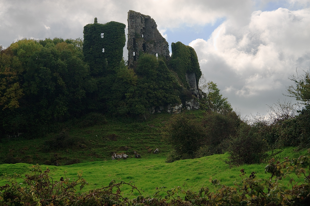
English: Castles of Munster: Carrigogunnell, Limerick This castle on a volcanic crag overlooking the Shannon estuary was probably founded by the de Burghs, but became a major seat of the O'Briens before being held by the earls of Desmond. It has a violent history. In 1536 after sustaining a prolonged barrage by cannon, it was surrendered to Lord Deputy Gray by its commander Edmund Cahill. He was hanged along with his entire garrison, but the castle was later recovered by the O'Briens. During the Cromwellian wars it was taken over by Captain Wilson, who occupied it, building a stable in the bawn. A Jacobite garrison of 150 men surrendered the castle to William III's forces in 1691, and shortly afterwards it was blown up. The castle is a mixture of periods; the roughly heart shaped outer enclosure extending down the slope dates from the C15, although the triangular section is a C16 addition. The north wall of the inner court on the highest part of the crag is C13. |
| Date | |
| Source | From geograph.org.uk |
| Author | Mike Searle |
| Attribution (required by the license) | Mike Searle / Castles of Munster: Carrigogunnell, Limerick / |
| Camera location | | View this and other nearby images on: OpenStreetMap |
|---|
_heading:225.00&language=en)
| Object location | | View this and other nearby images on: OpenStreetMap |
|---|
_heading:225.00&language=en)
Licensing[edit]

|
This image was taken from the Geograph project collection. See this photograph's page on the Geograph website for the photographer's contact details. The copyright on this image is owned by Mike Searle and is licensed for reuse under the Creative Commons Attribution-ShareAlike 2.0 license.
|
This file is licensed under the Creative Commons Attribution-Share Alike 2.0 Generic license.
Attribution: Mike Searle
- You are free:
- to share – to copy, distribute and transmit the work
- to remix – to adapt the work
- Under the following conditions:
- attribution – You must give appropriate credit, provide a link to the license, and indicate if changes were made. You may do so in any reasonable manner, but not in any way that suggests the licensor endorses you or your use.
- share alike – If you remix, transform, or build upon the material, you must distribute your contributions under the same or compatible license as the original.
File history
Click on a date/time to view the file as it appeared at that time.
| Date/Time | Thumbnail | Dimensions | User | Comment | |
|---|---|---|---|---|---|
| current | 12:47, 10 February 2019 | | 1,024 × 683 (768 KB) | Geograph Update Bot (talk | contribs) | Higher-resolution version from Geograph. |
| 09:21, 3 March 2011 |  | 640 × 427 (269 KB) | GeographBot (talk | contribs) | == {{int:filedesc}} == {{Information |description={{en|1=Castles of Munster: Carrigogunnell, Limerick This castle on a volcanic crag overlooking the Shannon estuary was probably founded by the de Burghs, but became a major seat of the O'Briens before bein |
You cannot overwrite this file.
File usage on Commons
There are no pages that use this file.